


“One tried to land by my cattle tank, but left when I approached. It had no number I could see. My biggest concern is that they (helicopters) are scaring my cattle. I want it to stop.”
– John Cores, Rancher
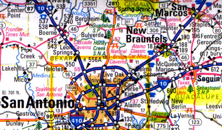
Updated – February 9, 2006 Guadalupe County, Texas – This past week, the San Antonio Lightning news website reported that the Federal Aviation Administration has not been able to identify two, so-called ‘dark helicopters’ reported near the ground on a Comal County, Texas, ranch. The ranch is actually in Guadalupe County, southeast of New Braunfels and east of San Antonio. On November 23rd, and a month later on December 22nd, Guadalupe County rancher, John Cores, filed a complaint with the FAA, after a black and another dark blue helicopter intruded where his cattle water and graze. Mr. Cores says he could not see ID markings on the helicopter.
He told the San Antonio Lightning: “One tried to land by my cattle tank, but left when I approached. It had no number I could see. My biggest concern is that they (helicopters) are scaring my cattle. I want it to stop.”
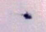
Mr. Cores did not photograph either of the two intruding helicopters. But out of curiosity, he got a camera to photograph a helicopter flying over his ranch at a higher altitude which he thought looked like the original offending choppers. He photographed a Robinson 22 or 44 long-tailed, small helicopter used for pilot instruction and other civilian work. FAA inspector, Tom Hennessee, received copies of the distant helicopter photos and told San Antonio Lightning that such complaints “are not uncommon” without explaining why low chopper intrusions are common. Mr. Hennessee also said “it is virtually impossible” to track down specific helicopters without knowing an ID number.
Contributing to the I. D. challenge is this odd fact: dark numbers on dark painted aircraft are legal. I talked to rancher John Cores this week about the problem that if dark colored numbers are legal on dark paint, how would anyone be able to see them? Mr. Cores had also received a letter from the FAA inspector saying the agency had closed the case due to insufficient evidence, meaning no I. D. numbers to investigate.
FAA Altitude Regulations for Aircraft
FAR Sec. 91.119, Para. B, C and D
(Federal Air Regulations)
Concerning minimum safe altitude which states “except when necessary for take-off or landing, no person may operate an aircraft below the following altitudes:
“A. Anywhere an altitude allowing, if a power unit fails, an emergency landing without undue hazard to persons or property on the surface.
“B. Over any congested area of a city, town or settlement or over an open air assembly of persons, an altitude of 1,000 feet above the HIGHEST OBSTACLE within a horizon radius of 2,000 feet of the aircraft.
“C. Over other than congested areas an altitude of 500 feet above the surface, except over open window or sparsely populated areas. In those cases, the aircraft may not be operated closer than 500 feet to any person, vessel, vehicle or structure.
“D. Helicopters. May be operated at less than the minimums prescribed in Para. B or C of this section if the operation is conducted without hazard to persons or property on the surface. In addition, each person operating a helicopter shall comply with any routes or altitudes specifically prescribed for helicopters by the Administrator (FAA).”
Interview:
John Cores, Guadalupe County rancher, New Braunfels, Texas: “I was born 58 years ago into an Air Force family. I grew up around aircraft. I have never had a problem with aircraft, especially a helicopter coming down in my backyard until November 23, and December 22, 2005.
I was told the helicopters had to have I. D. numbers. That was by Faye from the FAA, Local District Standards Office. She said they are 12 inches high. They can even be black numbers and a black background! Below is the incidence report I filed with the FAA.
Incidence report:
First Chopper
When? 1:30 p.m., November 23, 2005
WHERE? About 200 yards east southeast of 29 minutes 39.10 seconds north by 98 minutes 06.31 seconds west. That’s the location. Guadalupe County (not Comal Cty)
WHY? That’s the question.
HOW? About 1:30 p.m. on Nov. 23, 2005, I heard a helicopter approaching and stepped out the back door of my house to see a dark helicopter in a final approach mode from the northeast. The chopper flew low over my neighbor’s pasture and ended its descent hovering at about 10 feet over the catch pond that feeds my stock pond.
The chopper hovered for a few seconds, and then ascended to a thousand or so feet and headed back northeast. The helicopter was a dark black or blue with no visible numbers. The paint was finished in a clear coat that is shiny as opposed to a flat black.
2nd Chopper
On December 22, 2005, at 11 a.m., another dark chopper again visited the same location, only this time seemingly trying to stay 500 feet from persons and structures. The aircraft hovered for more than a few seconds and left. This incident made me recall another incident involving a helicopter. In October 2005, a helicopter actually landed in the pasture next to mine. It was like a smaller version of the local Air Life helicopter blue and white with a dolphin kind of shape. A man exited the helicopter and walked towards my neighbor’s house. I didn’t report it until after the November 23rd incident. I called my neighbor, explained the landing and said I didn’t think much of it at the time, only that it was odd. I figured my neighbor flew, or had a friend who flew. But he didn’t and he didn’t know about that day time landing behind his house.
Investigation:
Those were the incidents. We now turn to the investigation. Having had training and practice as a military policeman, I was curious about the mystery. I learned that a flight school was located at the New Braunfels Airport. 1.5 hours after the incident, I was at the New Braunfels Airport and saw two of the black birds. I was told by an airport employee that they belonged to the flight school. I asked to see the pilots, but no one was available. I asked to see flight plans and was informed they don’t file them.
It turns out this info was false, but it sent me off on a wild blue goose chase. It was not until December 22, 2005, at 5 p.m., that I saw a helicopter from the flight school when it flew over my house, apparently in no violation. It was a silver-colored helicopter. It landed at the New Braunfels Airport which I can see from my house. I called to verify it as belonging to the school and it did.
I talked with more than a few people in the industry. No one ever surveyed the site (at ranch), but everyone was quick to lecture me about helicopters. The story was remarkably the same.
First point: helicopters have different regulations than fixed-wing craft. They can come right down to the ground. They just can’t land.
Second point: it was probably a training exercise for emergency landing where the instructor tells the pilot ‘OK, the engine has quit. Pick a spot and land.’
Third point: Helicopters need to fly at low altitudes to check powerlines, gas lines, fence lines, and even work cattle. (These uses of the helicopter are obviously legitimate uses, but should be covered by flat plans and enforced as more development occurs and cases of abuse arise.)
I was even given a name of someone as the culprit. But it turned out his helicopter was white. It didn’t take long to see the existence of what I call the ‘Brotherhood of the Helicopter.’ I pushed all the buttons and got an in-your-face attitude in order to get someone’s attention.’
John Cores: “The entire industry pilots, support personnel and the FAA have been unable to give any answers to the questions raised by this incident. Indeed, the FAA’s own investigation lasted from Dec. 29 until Jan. 12, 2006. They never visited the site (on my ranch). So, we don’t know what it was. If it’s a training exercise, they need to go to a training field to do those training exercises. Like I said, I grew up around aircraft and never had a problem with them. I’m in the middle of 68 acres. It’s hard to put a helicopter down here any place, even if they are allowed to right on the ground without some sort of consequence. If anybody other than myself walks in among my cattle, they go berserk.
AND NOW YOU ARE SAYING THE CATCH-22 IS: IF THE HELICOPTER/S THAT HAVE COME DOWN ON YOUR PROPERTY ONE TO THE GROUND AND ONE CLOSE TO THE GROUND WHERE YOUR CATTLE ARE AND IF THEY ARE DARK COLORED AND IF THE I. D. NUMBERS ARE DARK, YOU WOULD HAVE NO WAY OF GETTING I. D. NUMBERS TO REPORT TO THE FAA IN THE FIRST PLACE?
That is the only thing that I can conclude from this. Now, who that was (in the dark choppers) and what they were doing remain questions that aren’t answerable because of that. So, we can’t find out. There is a very big question: who was that? And what are they doing there? That’s still unanswered.
AND WHAT YOU ARE RAISING IS THE QUESTION: IF THE RULES ARE DIFFERENT FOR HELICOPTERS, THEN THERE IS THE POTENTIAL FOR ABUSE LANDING NEAR WATER, NEAR CATTLE THAT CAN CAUSE PROBLEMS. THE ISSUE WOULD BE, WHY?
Exactly.”
Earthfiles Viewer Replies
1) February 6, 2006
“I have been a helicopter/airplane pilot for 20+ years and was based in South Texas for several years. The fuzzy pictures are possibly identifiable as a Robinson R-22. The mast and generally small round appearance is very indicative of this type helicopter.
“The R-22 is used as a training helicopter and as such someone is probably using this relatively out of the way area for training. They are occasionally used by Western ranches to round up cattle. I fly government aircraft and can assure you its no conspiracy.”

2) February 6, 2006
“From my years in the army and living by an airport these look like training helicopters these are the first copters that students learn to fly. I just hope they are not terrorist or drug dealers learning to fly out of FAA range.”
3) February 6, 2006
“The pictures of the helicopter(s) in your latest article on Earthfiles
appear to be similar to the OH-6A. See the links.
http://www.globalsecurity.org/military/systems/aircraft/oh-6-pics.htm
http://www.globalsecurity.org/military/systems/aircraft/oh-6-specs.htm “
4) February 6, 2006
“I’ve seen your Black Helicopter coming in for a landing at the San Antonio International Airport within the last few week. I thought it was unusual because it was completely black with no markings at all. I live in Comal County and I have seen several helicopters over the last year but they are usually to far away to tell if they have any marking.”
5) February 6, 2006
“In an effort to define just what type of aircraft is depicted in the picture of “The Black Helicopter” , I submit this from 40+ years of aviation activity.( Pilot, Aircraft mechanic, aircraft designer and builder .) Best estimate is the craft depicted is a two place reciprocating engine powered Robinson R-22. Given that this is a civilian aircraft (non-military) of limited range , a radial of 150 miles maximum can be ascribed to the possible area of inquest. A good starting point would be the review of all Robinson R-22`s located via the FAA Registry within this region of Texas. As this is a “standard category’ licensed manufactured civilian aircraft Identity numbers and registration should be on file (provided that this aircraft is being operated within the confines of the FAA Regulations) My guess is there is a flight training operation or a private operator that has been using the given airspace around the gentleman`s ranch as a practice area . Frankly his cows are safe, as this helio is not capable of lifting and flying away with anything more than sage brush caught on it`s landing skids with two folks on board. As far as annoying the cows or the rancher, well let`s just say it`s considered poor form to be conducting low level flight ops without asking permission of the given land owner…. Hope this aids in clearing up the situation.”
6) February 6, 2006
“Pictures look like Robinson R-22 Light Helicopters. I am a pilot and
the boom tail configuration seems correct. Their Range is only 200 miles, 300 with auxiliary tanks. That information might help in ID’ing the airport where they are based. If they are R-22’s they do not have an in-air refuel capability.”
7) February 5, 2006
“I’m a Veteran 20 year Naval Aviation Chief with 7k combat aircrew hours. The mystery helicopter on your site has a few features that narrow the type/model types. It was a fuzzy image, but I think this is close:
http://www.cbhelos.com/300CBi%20specs.jpg The absence of a distinct tail boom and rotor mast narrow things a bit. The outline of the front(cockpit) fuselage section is in the category of a small utility type helicopter. These are common with Sheriff departments and ranchers. I searched this and included a search result that has 3D views and things like the range. If somebody really wanted to find the helo, go for type/max range/color. Draw a max round trip range circle around the point observed on the map. Locate airports/heli pads- use an aviation map.”
More Information:
For more information about “black helicopters” in other earth mystery events, please see the following reports in Earthfiles Archives :
- 10/27/2005 — Updated Part 1: Unusual Animal Deaths – 22 Horses and 1 Burro Near Calhan, Colorado
- 09/13/2004 — “Clearview” Report on the Investigation of UFO Experiences on A Rocky Mountain Ranch
- 10/03/2002 — Chapter 5 – Mystery Stalks The Prairie
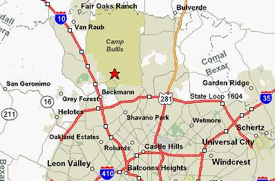
Camp Bullis Military Reservation
Regional Military Installation
“With a population of 130 military personnel, the mission of Camp Bullis is to train security police in ground combat skills.”
– Camp Bullis website

Website:
San Antonio Lightning Newspaper: http://www.sanantoniolightning.com/bhcores.htm
© 1998 - 2024 by Linda Moulton Howe.
All Rights Reserved.