

March 24, 2006 Richmond, Virginia – A CIA spy satellite photographed an unusual feature in the glacier back in 1973 during its Cold War observation missions of the Turkey/Russia border, but there was never any news because the satellite was not to be discussed in the interests of national security. Twenty years later in 1993, a retired CIA official confirmed an anomaly on Mt. Ararat was photographed in 1973. And recently a professor at the University of Richmond in Virginia has talked to the media about a more recent satellite photograph taken on February 1st, 2003, which he has been having analyzed by various intelligence experts. His name is Porcher Taylor, an Assoc. Prof. of Paralegal Studies in the School of Continuing Studies at the University of Richmond.
Recently he told me about how he first became interested in the 1973 satellite photo and his hope that new satellite imagery might provoke scientists to do a serious investigation at the 15,300 foot site on the western plateau. Mt. Ararat has long been linked to a Bible story about Noah building a big boat to collect all the world’s animals in pairs before a global flood. Here are some excerpts from Chapters 6 through 8 in the King James version about the Lord’s instructions to Noah:
“ Make thee an ark of gopher wood; rooms shalt thou make in the ark, and shalt pitch it within and without with pitch. And this is the fashion which thou shalt make it of: The length of the ark shall be three hundred cubits, the breadth of it fifty cubits, and the height of it thirty cubits.
“A window shalt thou make to the ark, and in a cubit shalt thou finish it above; and the door of the ark shalt thou set in the side thereof; with lower, second and third stories shalt thou make it.”
There is no explanation about what “gopher wood” is or what the exact length of a cubit is. However, religious scholars estimate a cubit was around 19 inches, or half a meter. So 300 cubits would be around 450 feet long, bigger than a football field.
Genesis Chapter 7 describes the 40 days of rain and a flood that lasted for 150 days. Quoting from Genesis, Chapter 8:
“And the waters returned from off the earth continually: and after the end of the hundred and fifty days, the waters were abated. And the ark rested in the seventh month, on the seventeenth day of the month, upon the mountains of Ararat.”
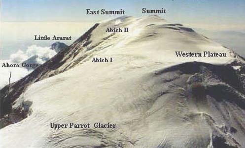
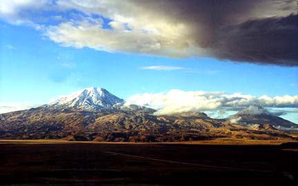
Mt. Ararat is a volcano that rises 16,945 feet high in eastern Turkey on the borders of Iran and Armenia, which was formerly the Soviet Union. A local mythology has evolved over a long time from residents in the region about people who have seen a large boat sticking out of a glacier. But to date, no one has ever agreed on a location or photographed such a discovery – although the western plateau featured in the spy satellite photos is where some locals have pointed when asked about the Noah’s ark legend.
Here now is Prof. Porcher Taylor from the University of Richmond explaining how he first learned about the 1973 CIA satellite photo and what he has learned since.
Interview:
Porcher L. Taylor III, J.D., Assoc. Prof., Paralegal Studies, School of Continuing Studies, University of Richmond, Richmond, Virginia: “In 1973, as a cadet on the debate team at the U. S. Military Academy at West Point, I first heard a powerful rumor that was ricocheting off of the walls at that time that one of our CIA KH-9 satellites accidentally imaged what appeared to be the bow of a huge ship sticking out of a glacier on Mt. Ararat at about 15,000 feet.
[ Editor’s Note: Wikipedia: “The KH-9 Spy Satellite was Codenamed Hexagon. KH-9 was a reconnaissance satellite used by the United States from June 1971 to April 1986. The satellite was popularly known as the ‘Big Bird.’
“The KH-9 was originally conceived in the early 1960s as a replacement for the Corona search satellites. The goal was to search large areas of the earth with a medium resolution camera. The KH-9 carried two main cameras, although a mapping camera was also carried on several missions. The photographic film from the cameras was sent to recoverable reentry vehicles and returned to earth, where the capsules were caught in mid-air by an aircraft. Four reentry vehicles were carried on most missions, with a fifth added for missions that included a mapping camera.
“Over the duration of the program the lifetime of the individual satellites increased steadily. The final KH-9 operated for up to 275 days. Different versions of the satellite varied in mass, most weighed 11,400 kilograms or 13,300 kg. Satellites were manufactured by Lockheed and the camera was designed by Itek, but produced by Perkin-Elmer. There were 21 launch attempts and one failure.
“The KH-9 was never a backup project for the KH-10 Manned Orbiting Laboratory. It was developed solely as a replacement for the Corona search system.”]
WAS THAT SUPPRESSED BACK THEN AS PRIVATE INTELLIGENCE INFORMATION?
Twenty years later in 1993 in making a speech before the Palm Beach Roundtable and during the Q & A session, the late Dr. George Carver – who at the time was a senior retired CIA official, a Ph.D. from Oxford, a graduate of Yale University and considered the most highly decorated CIA official at the time – confirmed publicly during the Q & A session before about 400 people at the Palm Beach Roundtable after I asked him to confirm publicly that the rumor I heard as a cadet back in 1973 was absolutely true. That was the first time that I’m aware of that an insider, especially an insider like Dr. Carver, an inside the intelligence community type individual, confirmed on the public record that indeed the CIA had very intriguing satellite images of what appeared to be a bow of a huge ship sticking up out of a glacier on Mt. Ararat.
Dr. Carver related to me when I asked him that question that day on March 11, 1993, before the Palm Beach Round Table, he said he immediately recalled back in 1973 a morning breakfast meeting in Langley CIA headquarters – a meeting with the senior hierarchy of the CIA. At the time, Dr. Carver was a senior CIA official. They were about to discuss a classified matter. He said he would never forget when Carl Duckett (deceased), who at the time was Dep. Director for Science and Technology at the CIA, got up and said, ‘Gentlemen, before we discuss that classified matter this morning, I just want to let you know that one of our space-based birds, a KH-9, recently flew over Mt. Ararat and it would appear – based on the initial assessment by some of our photo interpreters – that the Noah’s Ark story in the book of Genesis might be literal history.
Dr. Carver said that the room immediately erupted in awe and laughter because the consensus was, ‘Gee whiz, we might have made the greatest archaeological discovery in history and we can’t talk about it publicly because it was taken by classified technology.’
My thinking was that if anyone on the planet knew what may, or may not, be up on Mt. Ararat – myth, fable or fact – it would certainly be the CIA with its spy satellite capability. Therefore, since I heard this as a cadet at the Academy and the Academy had a great rumor pipeline right to the Pentagon and CIA and White House at the time, it made a lot of sense to me that there probably was potentially something manmade on Mt. Ararat and potentially of a nautical or naval type construction.
February 1, 2003 QuickBird Satellite Image of Ararat Anomaly
NOW, LET’S JUMP TO 2006 AND WE HAVE A LOT MORE SOPHISTICATED SATELLITES UP THERE. WHAT IS THE LATEST DATA ON SIZE AND EVERYTHING THAT YOU HAVE LEARNED THAT HAS PUSHED THIS STORY FORWARD?
We have a paradigm-busting QuickBird satellite data of the Ararat anomaly that was acquired on February 1, 2003, at my request, pursuant to my research priorities in this project. Digital Globe, which owns QuickBird – the world’s first 2-foot resolution satellite – was kind enough to fly gratis, free. These missions otherwise cost several thousand dollars – to fly Mt. Ararat off and on for a year. Finally, the cloud cover broke. Unfortunately, since this is at 15,300 feet, you have a constant problem with cloud cover from satellites, or even from planes. The cloud cover finally broke on February 1, 2003. No clouds at all on Mt. Ararat. We have a very clear, pristine, stunning image of the Ararat anomaly at 2-foot resolution – the best resolution ever for a commercial satellite.
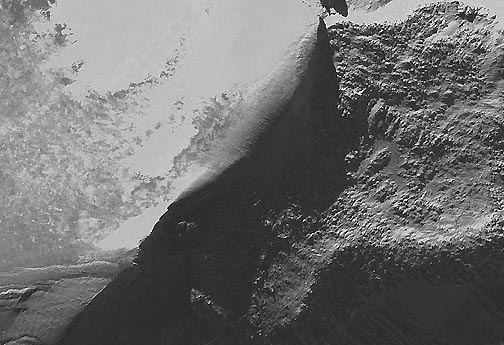
Linda, it’s a paradigm-busing image for several reasons. First: it’s way too big to be the remains of the ‘fabled,’ some would say; others would say ‘factual’ Noah’s Ark. Every pixel in the satellite image is 2 feet. I had Rod F., who is a world-class retired intelligence analyst with the USAF for 23 years; make an analysis of the photo and to measure the pixels using special software. From bow to stern, if you want to call it that, of this formation, structure, anomaly, oddity – whether it’s a rock formation or something more interesting – it’s 1,015 feet.
Virtually every Biblical scholar would tell you that the Ark was probably about 450 feet long because a cubit is supposed to be about 18 inches. 300 cubits would therefore be about 450 feet long.
What we’re looking at in the QuickBird satellite photo, astonishing as it is, is something that is well over 2 times that size. So, that’s a paradigm-buster there that ‘Gee Whiz, it can’t be Noah’s Ark because it’s way too big. So, therefore, it must be some kind of strange rock formation or something else.
The other paradigm-buster on this is that the satellite image really does show a titanic-shaped structure, more like a modern ship and not the classical, traditional depiction of Noah’s Ark as being a rectangular, unsophisticated barge which most Biblical scholars would probably agree the Ark probably looked like.
This has stunning, unbroken symmetry for 1,015 feet. It arcs perfectly forming the bottom of a hemisphere all the way from a ‘bow’ back to the ‘stern.’ It does arguably look like a stern all the way back there.
Then that raises another paradigm-buster and that is that no one knows what ‘gopher wood’ is (mentioned in Bible). There has been a lot of speculation throughout history about what gopher wood is. But it seems to be a very vague or ambiguous term in the Genesis record because it just says ‘gopher wood’ and there is no explanation about what that might be.
The problem is with the anomaly that if it is some kind of nautical or naval structure of some kind, then there is no way it would float. It would break apart on the water. This is something rivaling the size of a modern aircraft carrier.
I had a Naval architecture team that I brought together in the last three weeks. They have spent several hours at my request to analyze the satellite image and the Genesis (Bible) architectural blueprint to determine whether or not it is feasible or possible to build some kind of vessel out of wood of this size along the structural lines of what we are seeing in the QuickBird satellite image, as well as the GeoEye’s IKONOS satellite from 1999-2000. Ikonos is owned by GeoEye, another world-class company that has flown satellite missions for me over Mt. Ararat.
At a 1,015 feet long – if that is the full length and it appears to be because it is under heavy ice now – the width is hard to measure because whatever this is, it is leaning heavily at maybe 30 degrees and therefore it is hard to tell what the width is because it’s at an angle. But, it appears with each pixel being 2 feet, it does appear that this might be about 160 feet wide. Why is that potentially significant? In the Genesis architectural blueprint, we are given 300 cubits by 50 cubits. For my research purposes, a cubit is not really relevant to my analysis because no one is absolutely certain as to what the size of a cubit was.
What we have is 300 to 50; that is a 6 to 1 ratio (which is also) the Genesis architectural blueprint for the proportionality between the length and the width. At 1,015 feet long and roughly 160 feet wide, we fall into a 6:1 length-to-width ratio, which would be in the ball park of the Biblical dimensions.
That might be a huge coincidence. But then again, that might be something more interesting, which is my segue to talk about the intelligence community. That is for over 13 years, I have had very intriguing meetings and many conversations with intelligence officials, including several very senior officials and some who are personal friends of mine or are individuals I’m personally acquainted with – about the Ararat anomaly.
I am struck also by their high interest and their actual excitement as to what they think this might be on Mt. Ararat, based on high-resolution spy satellite images of the anomaly, which they might have in their archives.
WHY HASN’T ANYONE GONE THERE SINCE WE COULD DROP A TEAM OF SCIENTISTS DOWN FROM A HELICOPTER?
Absolutely. The vast majority of individuals and groups that have been climbing Mt. Ararat off and on over the last 30 or so years have focused on the Ahora Gourge, which is a mile and a half away on the other side of the mountain and not this anomaly site, which is the CIA’s anomaly site. The correct site is 15,300 feet on the northwest corner of the western plateau of Mt. Ararat.
So, when I first got involved, I was surprised to this day that I’m not aware of anyone out there who has actually gone up to the site and reached out and touched this anomaly and confirmed this is a bunch of ice, or bunch of strange rocks, or something more interesting. Yes, there have been some private photographs, but from a distance.
I’m not even aware of anyone who has gotten close enough with a camera to definitively determine what this may or may not be. My goal – my initial Phase 1 of my project – is using satellite archaeology to get clear enough satellite imagery of the anomaly to push over center a lay person or world class scientist, who I’ve got on my team and cannot mention, but to push over center those who doubt or don’t think there might be something at the site. Push away the Noah’s Ark issue. Is there something at this site?
CAN YOU TALK ABOUT YOUR NEXT RESEARCH STEP?
My next step is I have a Naval architecture team that’s come together and they are analyzing the images and in the next 12 months, three new birds, three new commercial birds, are going to be flying from Vandenberg AFB taking this on to a much higher resolution level. We’re talking about a half-meter, going from two feet, to half-meter resolution with two of these satellites. And then also a radar satellite is going down from 8 meters to 3 meters. I’ve asked all three companies to fly Mt. Ararat on their calibration missions and we will see what they say over the next 12 months or so. That will help make Mt. Ararat more transparent to the discerning eyes, secular, dispassionate scientists.
I want to emphasize I’ still in Phase One of my project. I haven’t any interest in even going to Turkey or even touching Mt. Ararat at this point.
YOU ARE HOPING IT WOULD PROVOKE OTHERS PERHAPS TO DO THAT.
Absolutely.”
© 1998 - 2024 by Linda Moulton Howe.
All Rights Reserved.