Part 3:  Roswell Rock Lab Analysis

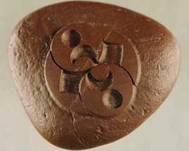
“The pattern is remarkable. Obviously, it is something that took a lot of care and knowledge to produce because this hard, iron-rich sandstone with magnetite is not easily worked.”

- James Constantopoulos, Ph.D., Geologist

Left:  Mysterious 1.96 inches (5-centimeters) by1.69 inches (4.3-centimeters) diameter rock that weighs 50.78 grams, measured on July 15, 2008, in Physical Sciences Department at Eastern New Mexico University. The carved rock was found by Roswell auto repairman, Robert Ridge, 50, during his September 4, 2004, deer hunting trip near Capitan, New Mexico, 17 miles southeast from the July 1947 UFO crash site between Corona and Roswell. Image by Robert Ridge.   Right:  Wheat formation, 120 feet long, reported August 2, 1996, below the Liddington Castle hill fort in Chisledon, near Swindon, Oxfordshire, England, on Wiltshire County border. Aerial image © 1996 by Steve Alexander.   Also see:  Cropcircleconnector.com.
Above:  Mysterious 1.96 inches (5-centimeters) by1.69 inches (4.3-centimeters) diameter rock that weighs 50.78 grams, measured on July 15, 2008, in Physical Sciences Department at Eastern New Mexico University. The carved rock was found by Roswell auto repairman, Robert Ridge, 50, during his September 4, 2004, deer hunting trip near Capitan, New Mexico, 17 miles southeast from the July 1947 UFO crash site between Corona and Roswell. Image by Robert Ridge.   Below:  Wheat formation, 120 feet long, reported August 2, 1996, below the Liddington Castle hill fort in Chisledon, near Swindon, Oxfordshire, England, on Wiltshire County border. Aerial image © 1996 by Steve Alexander.   Also see:  Cropcircleconnector.com.


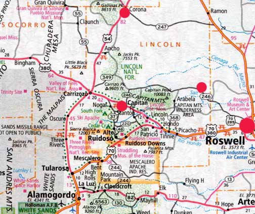
Roswell is larger red circle on far right. Cedar Hill deer hunting trail is smaller red circle on Highway 246 (Pine Lodge Road) just west of Chavez and Lincoln County borders northwest of Roswell. Capitan is middle red circle and Corona is top center of map. Cedar Hill deer trail is 17 miles southeast of the July 4, 1947, crash site between Corona and Roswell.

Return to Part 1

July 18, 2008  Portales, New Mexico - I contacted the original geologist in Portales who did the first February 2005 energy-dispersive X-ray fluorescence spectroscopy on the rock for Robert Ridge. I learned that all the original test results had been lost a couple of years ago in a computer hard drive crash. So, on Tuesday, July 15, 2008, I drove to Portales, New Mexico, to meet Robert for a second round of testing of the mysterious carved rock at the Physical Sciences Department of Eastern New Mexico University. The Chair of that department is Geology Professor James Constantopoulos, Ph.D., who has taught at ENMU for nearly twenty years. Prof. Constantopoulos began by examining the rock using a binocular microscope.


Click here to subscribe and get instant access to read this report.

Click here to check your existing subscription status.

Existing members, login below:


© 1998 - 2024 by Linda Moulton Howe.
All Rights Reserved.