

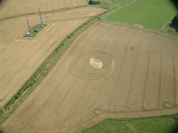
August 5, 2003 Devizes, Wiltshire, England – On Sunday afternoon, August 3, 2003, a new formation was reported at Morgan’s Hill on the other side of the North Down where the four tumuli and 11-concentric-ring formation was discovered on July 6, 2003. The next morning, Monday, I traveled to the formation and was impressed with the springy feeling the crop had under my feet. There, I met up with photographer and video producer, Bert Janssen, who has studied the geometry of crop formations for several years. He has produced two award-winning documentaries, Contact and Crop Circles: The Research. I explained to him that I had counted twenty-eight rays coming off one side of the large central flattened circle and seventy-eight coming off the opposite side. He walked around the top rays and into the large central circle trying to see if the rays lined up with the center “fountain” of wheat. They did not and the formation’s geometric structure became a challenge to understand.
Interview:
Bert Janssen, Agricultural Engineer, Photographer and Video Producer, Devizes, Wiltshire, England: “When I first was in the formation August 4, it looked like the rays were really random. It looked like the rays were going in all different directions. People told me when I was in this formation that this randomness was due to mistakes in the design of the formation. So I looked at them and noticed that in certain parts, some of the lines have an extension where there is a line, then standing crop, then the line extends further. That, I thought, is difficult to do. It’s not easy to make a line, then a piece of standing crop and then extend the line (that is perfectly straight from the other part of the line.) But if you are capable of doing that, then you are not going to make mistakes with the rays. That wouldn’t make any sense.
So, when I looked further, I saw that the rays were not random. Although they were not pointed at the center (of the large flat circle), there was a definite purpose in them. They were pointed to one specific spot in the formation which was on the edge of the central circle. If you would stand on that exact spot where the rays came together and you would look over the center of the circle, you would see that it was exactly aligned to the top of the hill where there is a little stone monument marking the top of the hill. This one specific spot at the edge of the center circle and this monument were exactly on one line. The whole formation was aligned to the top of the hill. So, the rays were not random and there were no mistakes in it.
AT THAT SPOT WHERE ALL THE LINES INTERSECTED, YOU ALSO NOTICED IT WAS THE BEGINNING OF A CRESCENT?
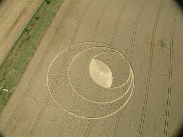
Yes. When I saw the aerial photograph, I noticed the central flattened circle looks like an eye. It’s not perfectly round. But if you look really closely, you will see that it’s a circle with something added to it. There is a crescent added to it and the crescent starts exactly at the spot at the edge of the circle where all the lines intersect. And on the other side of the circle where the imaginary line that connects to the stone monument leaves the formation, there the crescent ends. So, it is exactly marking the start and the end of the crescent.
LOOKING AT THE AERIAL PHOTOGRAPHS TODAY, ANY ADDITIONAL COMMENTS?
It’s much more straightforward than I thought when I was in the field. It looks much simpler in the aerial picture. There are center points for each ring. The center of the flattened circle (where the wheat stands up in a little ‘fountain’) forms the center of the middle ring. The central point for the entire formation is that spot at the edge of the center circle through which all the rays converge. And that spot lines up exactly with the Morgan Hill stone monument so the entire formation lines up on the imaginary straight line that runs through the stone and that central spot.
Another thing I notice looking at this photograph today is that there is a 3-dimensional aspect to the formation. It’s like a volcano that rises with a hole on top.
FROM A GEOMETRY POINT OF VIEW, IS THERE ANYTHING ABOUT THAT YOU WOULD SAY IS REMARKABLE?
Yes, this is one of the very few formations that I know about which has a distinct line up with the landscape. Most of them have the geometry that is only in relationship with the field itself – let’s say, the tramlines in the field – but not with the landmarks around it.
THAT ALIGNMENT IS WITH THAT MORGAN HILL MARKER STONE?
Yes, the Morgan Hill marker stone is aligned with it perfectly.
WHEN YOU ARE IN THE MORGAN HILL FORMATION, ON THE OTHER SIDE OF THE HILL IS THE NORTH DOWN OF FOUR TUMULI AND THE ‘FIFTH BARROW’ THAT HAS BEEN CREATED BY THE 11-CONCENTRIC RINGS FORMATION THAT OCCURRED ON JULY 6. NOW, THERE APPARENTLY IS A SIMPLE CIRCLE THAT APPEARED IN AND AROUND THE TIME THAT THIS MORGAN HILL FORMATION CAME. HAS ANYBODY SEEN WHETHER OR NOT THERE IS A STRAIGHT LINE ALIGNMENT BETWEEN MORGAN’S HILL, THE SIMPLE CIRCLE AND THE FOUR BURIAL MOUNDS AND THE JULY 6 CONCENTRIC RING FORMATION?
The crop formations on a map do seem to line up. Further, North Down, the circle and Morgan’s Hill do seem to align with Oliver’s Castle where in the past, several formations have been discovered, including the 6-fold geometry ‘snowflake’ of 1996. A young man named John Weyleigh allegedly photographed several glowing balls of light that flew low over the crop and simultaneously, the pattern seemed to form. To date, that videotape has never been proven a hoax or fact.
ARE YOU AWARE OF ANY OTHER FORMATIONS THIS YEAR OR IN THE PAST THAT HAVE BEEN ALIGNED WITH A SPECIFIC MARKER IN THE LANDSCAPE?
The only other one I have seen is the one on the other side of the hill this year. We have the North Down formation which lines up with the barrows. But this one at Morgan’s Hill is much more clear, lining up with that one specific stone marker to create the geometry of the formation. I have never seen that before.
When I think about it, this 3-dimensional aspect could be a representation of a barrow. It looks a little like a raised barrow.”
Field Notes from England to be continued.
Websites:
http://home.clara.net/lucy pringle
http://www.cropcircleconnector.com
http://www.cropcircleresearch.com
http://www.temporarytemples.co.uk
http://www.invisiblecircle.de and http://www.invisiblecircle.org/ser/d-archiv-2003.html
http://www.busty-taylor.com/cropper/98busty2.htm
© 1998 - 2026 by Linda Moulton Howe.
All Rights Reserved.