First 2013 Crop Pattern:  Gray, Tennessee

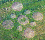
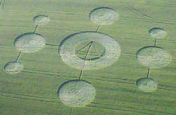
“I looked all around the pattern in my hay field and there were no tracks anywhere. But some tall grass was going clockwise and some was going counterclockwise. How is that possible?”

- Connie Osborne, Land Owner, Gray, Tennessee


Gray, Tennessee (upper right red circle), is 21 miles northwest of Johnson City. Madisonville, Tennessee (lower left red map marker) - where wheat formations occurred in 2007 and 2011- is 3.5 hours southwest of Gray, or about 200 miles.
 The Gray, Tennessee, crop pattern was reported May 13, 2013, in 4-foot-tall grasses growing in Connie Osborne's hay field along Old Gray Station Road about 21 miles northwest of Johnson City and about 200 miles northeast of Madisonville, TN (lower left red marker), where previous large wheat formations below were reported in the same wheat field on May 15, 2007, and May 16, 2011, southwest of Knoxville. Aerial May 14, 2013 © by Siri Karta.
The Gray, Tennessee, crop pattern was reported May 13, 2013, in 4-foot-tall grasses growing in Connie Osborne's hay field along Old Gray Station Road about 21 miles northwest of Johnson City and about 200 miles northeast of Madisonville, TN (lower left red marker), where previous large wheat formations below were reported in the same wheat field on May 15, 2007, and May 16, 2011, southwest of Knoxville. Aerial May 14, 2013 © by Siri Karta.
Top:  May 15, 2007, Madisonville, Tennessee, wheat pattern about 170 feet in diameter with crop laid down in counterclockwise circles and a triangle in the center circle of standing wheat. Aerial image © 2007 by Mark Boring, Monroe County Buzz. For more information, see 2007 Earthfiles.   Bottom: May 16, 2011, Madisonville, TN, pattern in same wheat field as the May 15, 2007, formation. Aerial image © 2011 by Mark Boring, Monroe County Buzz.


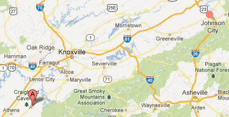
May 31, 2013  Gray, Tennessee - At 8 AM Monday, May 13, 2013, in Gray, Tennessee, 18-year-old Tim Blumberg went to the mailbox to place a letter his mom wanted mailed. He was surprised to see a pattern in the nearby hay field that was not there the day before. The Blumbergs are neighbors of Connie Osborne, 62, who was born in Carter City, Tennessee, only twenty-one miles from Gray, where she moved in 1979. Connie works for Host Engineering where she is a solder tech. She solders printed circuit boards for hard drives. The lowest part of her 8 1/2 acre farm is a field of eight different grasses that she grows for another neighbor to harvest as hay for his animals in exchange for his taking care of her property. That hay field is about twenty feet lower than her house and is dotted with large slabs of limestone that are part of the limestone beneath her hayfield and land.


Click here to subscribe and get instant access to read this report.

Click here to check your existing subscription status.

Existing members, login below:


© 1998 - 2024 by Linda Moulton Howe.
All Rights Reserved.