San Andreas Fault So Stressed, Next Quake Could Be Magnitude 8
“What’s the probability that we’re going to have a large earthquake, magnitude 6, 7 or 8, on the southern part of the San Andreas Fault? There is about a 70% likelihood of a large earthquake within the next 30 years.”
– Seismologist Debi Kilb, Ph.D.
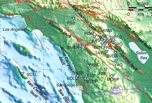
Blue triangles indicate 2006 small quake activity along San Jacinto Fault, Elsinoro Fault, and Rose Canyon Fault, while the San Andreas Fault near the Salton Sea is building more and more energy in a “locked up” mode, moving only 1 inch per year. Map source: USGS.
July 27, 2006 La Jolla, California – Last month, the June 22, 2006, issue of the science journal Nature, published recent detailed research of the San Andreas and San Jacinto faults in Southern California. The data shows the San Andreas so stressed that its next quake release of energy could be a magnitude 8 on the Richter scale. The San Andreas Fault is considered the main boundary between the Pacific and North American tectonic plates that are slowly moving past each other. Some day in the far distant future, those moving plates might even break off sections of the Pacific coast into the ocean. The tension between those moving plates is what makes California “earthquake country.”
[ Editor’s Note: USGS reports that earthquake magnitude “is a measure of the size of an earthquake. The Richter Scale, named after Charles F. Richter of the California Institute of Technology, is the best known scale for the measuring of magnitude (M) of earthquakes. The scale is logarithmic; a recording of 7, for example, signifies a disturbance with ground motion 10 times as large as a recording of 6. The energy released by an earthquake of M 7, however, is approximately 30 times that released by an earthquake of M 6; an earthquake of M 8 releases 900 times (30×30) the energy of an earthquake of M 6. An earthquake of magnitude 2 is the smallest earthquake normally felt by humans. Earthquakes with a Richter value of 5 or higher are potentially damaging. Some of the world’s largest recorded earthquakes–on January 31, 1906, off the coast of Colombia and Ecuador, and on March 2, 1933, off the east coast of Honshu, Japan–had magnitudes of 8.9 on this scale, which is open ended.
“As the Richter scale does not adequately differentiate between the largest earthquakes, a new “moment magnitude” scale is being used by seismologists to provide a better measure. On the moment magnitude scale, the San Francisco earthquake is estimated at magnitude 7.7 compared to an estimated Richter magnitude of 8.3.
“Intensity is a measure of the strength of shaking experienced in an earthquake. The Modified Mercalli Scale represents the local effect or damage caused by an earthquake; the “intensity” reported at different points generally decreases away from the earthquake epicenter. The intensity range, from I – XII, is expressed in Roman numerals. For example, an earthquake of intensity II barely would be felt by people favorably situated, while intensity X would produce heavy damage, especially to unreinforced masonry. Local geologic conditions strongly influence the intensity of an earthquake. Commonly, sites on soft ground or alluvium have intensities 2 to 3 units higher than sites on bedrock.”]
To put a magnitude 8 earthquake into perspective, one hundred years ago on April 18, 1906, San Francisco was hit by an early morning earthquake between magnitude 7.7 and 7.9. That quake ruptured the northernmost section of the San Andreas fault for 296 miles. From San Juan Bautista to Cape Mendocino, that 1906 earthquake stunned geologists with its huge horizontal displacement in the Earth’s crust. At least 3,000 people died. Broken gas pipes set the city on fire.
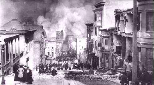
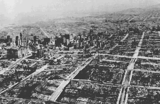
The earthquake hit at 5:12 a.m. local time on April 18, 1906. This photograph shows Sacramento Street as fire approaches. Source: Steinbrugge Collection of UC Berkeley Earthquake Engineering Research Center. Photograph by Arnold Genthe.This photograph, taken by George Lawrence from a series of aerial kites five weeks after the great earthquake of April 18, 1906, shows the devastation brought on the city of San Francisco by the quake and subsequent fire. The view is looking over Nob Hill toward business district, South of the Slot, and the distant Mission. The Fairmont Hotel, far left. dwarfs the Call Building. Source: Steinbrugge Collection of UC Berkeley Earthquake Engineering Research Center. Photo courtesy of Harry Myers.
More recently, Prof. Yuri Fialko of Scripps Institution of Oceanography at the University of California, San Diego, analyzed high resolution images taken by European Space Agency satellites. He combined the visual imagery with data from historic geological records, Global Positioning System readings and current seismic instruments stationed every 20 meters. The result is a study with a factor of a thousand times improvement in spatial resolution.
Prof. Fialko found more evidence that the southern San Andreas fault is “mostly locked up.” Not being able to move forward much, the fault builds up stress. Currently, the Southern California San Andreas is only moving about one inch per year. According to Prof. Fialko, that means during the last 300 years, the southern San Andreas fault has accumulated so much locked up energy that when it finally breaks that lock, the resulting earthquake will be huge – between magnitude 7 and 8. This also means that the city of Los Angeles or the San Bernardino/Riverside region could be hit by a seismic event as big as the 1906 San Francisco earthquake. When could the next big one happen in Southern California? The research indicates a 70% chance in the next thirty years.
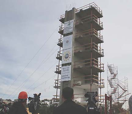
Prof. Fialko was surprised to learn that the San Jacinto Fault, a little west of the San Andreas, is moving at about twice the speed as earlier estimates. So, the San Jacinto Fault has built up a lot of energy which could break out in a magnitude 7 earthquake. What if both the San Andreas and San Jacinto Faults erupted at the same time? Seismic engineers at UCSD Jacobs School of Engineering’s Englekirk Structural Engineering Center have been testing buildings on a “shake table” to see what various intensities of shaking can do.
On January 14, 2006, a 7-story building built on their 25 foot by 40 foot shake table was subjected to ground motions equivalent to the January 17, 1994, Northridge earthquake. What the engineers are learning is that wood frame construction will collapse. But smaller concrete and reinforced steel frames will survive powerful earthquakes with only minor damage. The research from several years of work on the shake tables at UCSD have also caused most of Southern California’s freeway bridges to be retrofitted to withstand severe ground shaking. The problem is that a magnitude 8 earthquake could seriously affect several square miles wherever it hits. Older homes and buildings built from wood frame construction could collapse in huge numbers.
This week I talked with Prof. Debi Kilb, a seismologist at the Scripps Institution of Oceanography in La Jolla. She worked with Prof. Fialco on his San Andreas and San Jacinto Fault investigations and begins with the question that Prof. Fialco wanted to answer.
Interviews:
Debi Kilb, Ph.D., Seismologist, Scripps Institution of Oceanography, University of California-San Diego, La Jolla, California: “What’s the probability that we’re going to have a large earthquake, magnitude 6, 7 or 8, on the southern part of the San Andreas Fault? There is about a 70% likelihood of a large earthquake within the next 30 years. If you look at the southern part of the San Andreas Fault and ask how long is it? It’s about 100 miles long. So how large can an earthquake be on a 100-mile-long fault segment? The answer is a magnitude 7 or 8.
For the San Jacinto Fault, which is parallel to San Andreas – just further to the west – it’s not quite as long and the largest one we expect to occur on the San Jacinto Fault is only a magnitude 7.
BUT THAT’S BIG.
It is definitely big.
SINCE YOU ARE TALKING ABOUT TWO FAULT LINES WITH BOTH HAVING A POTENTIAL TO RELEASE SOMEWHERE BETWEEN A MAGNITUDE 7 AND 8 WITHIN THE NEXT 30 YEARS, THAT’S GOING TO HAVE SERIOUS CONSEQUENCES ON THE LARGE POPULATIONS THAT LIVE WHERE BOTH OF THOSE FAULTS ARE.
That’s right. It’s not necessarily within the next 30 years that we expect it. We expect the earthquake could happen today, tomorrow, or maybe even 100 years from now (with a 70% chance it will occur in the next 30 years, according to Prof. Yuri Fialko’s study). What would that mean for the nearby communities? One thing we worry about is what direction will the earthquake rupture? If the earthquake goes from the south to the north, all the energy is going to be directed to the north. In that case, those folks in Los Angeles will feel the brunt of it much more than those folks to the south.
On the other hand, if the earthquake ruptures from the north to the south, most of that energy is going to be going south. In that case, people in Mexico would get more of the brunt than people to the north. So rupture directivity really plays a role in terms of who is going to get hit most, what’s going to be the structural damages, and what kind of ground motions are we going to expect.
HAVE YOU DONE ANY COMPUTER MODELING THAT GIVES ANY INDICATION ABOUT WHICH MIGHT HAPPEN MORE THAN ANOTHER?
There have been all kinds of modeling that has gone on. But you can think of it as dominoes. We don’t know exactly what the small-scale fault structure is. If you imagine lining up dominoes and someone gets to take out ten or twenty of them and add in another thirty, what’s going to happen when you hit the system is that it’s really going to change. But we can do an overall study and ask: what are the general characteristics? What are the things that we absolutely know and then incorporate the uncertainties.
HOW DOES THAT COME OUT IN TERMS OF WHAT MIGHT PROBABLY HAPPEN?
That’s where they got the 70% likely within the next 30 years, and could be as long as a hundred years. An 8 can be very devastating. As you said, the 1906 San Francisco earthquake was approximately a magnitude 8 earthquake and very devastating for that city.
San Jacinto Fault Moving More Rapidly Than Expected
What the Fialco study also showed is that the rate of movement on the San Jacinto fault is twice as big as we expected. What this means is that it will probably have twice as much energy released in the same period of time than previously expected.
Does that mean we’re going to have an earthquake today or tomorrow? Not necessarily. Just that the rate is twice as high. One thing is that the plate tectonic boundary there – most people think that the San Andreas Fault is accommodating most of the plate tectonic movement. But the Fialco study is showing that some of that (movement) is being accommodated by the San Jacinto Fault right next door. So, the San Andreas Fault and the San Jacinto Fault are two major players in how the plate tectonic stresses are being accommodated in that region.
WOULD YOU SAY IT’S A GOOD GUESS THAT THE SAN ANDREAS FAULT WILL ERUPT FIRST?
Your guess is as good as mine. These things have a repeat time of about 300 years. We haven’t been studying them for longer than about 600 years or so. We don’t really have the repeat time and data to tell us that.
THE AREAS THAT WOULD BE AFFECTED THE WORSE GIVEN AN 8 MAGNITUDE ON THE SAN ANDREAS, WOULD BE WHICH SECTION ON THE SAN ANDREAS FAULT?
It would be right under where the earthquake occurred. So, if we had an earthquake that occurred just east of the Salton Sea, that region would feel the brunt of it. So, the closer you are to the earthquake rupture, typically that’s where you are going to have the most damage.
WHAT DO THE COMPUTER MODELS INDICATE MIGHT BE THE MOST LIKELY PLACE TO ERUPT?
One thing they have modeled is looking at a rupture in the southern part of the San Andreas Fault and if it ruptures from the south to the north up towards Los Angeles, the L. A. basin kind of rings like a bowl of jelly. When you get that going on, you can think of waves washing back and forth. These are waves in hard rock and that’s going to cause a lot of damage.
WOULD YOU HAVE THE SAME CONCERN WITH THE SAN JACINTO FAULT?
Yes, because that fault is just a little further to the west there.
IT HAS THE POTENTIAL TO RELEASE 7 ON THE RICHTER SCALE?
Approximately, yes. We don’t know if they are going to all rupture all at once in one large earthquake? Or in a series of smaller earthquakes, magnitudes 5s and 6s?
WHAT IS YOUR OWN SPECULATION ABOUT WHAT MIGHT HAPPEN?
I just always think: Be prepared, not scared. We don’t have enough data to favor one over the other.
What Should People Do During Earthquakes?
AS A PERSON STUDYING SEISMOLOGY, WHAT DO YOU RECOMMEND TO THE PUBLIC IS THE BEST THING TO DO IF YOU’RE IN A HOUSE OR APARTMENT OR STRUCTURE?
The first thing you want to do is figure out where you are almost every day all day. If you spend 8 hours at your desk, look around and see what might fall on you. If you have your bowling ball collection above you, you might want to move it down to a lower level. If you have an insecure ceiling fan that’s just hanging on by one wire, you might want to secure that.
Just some simple ten minutes to look around and say, ‘What could fall on me and where can I move things?’ That will really help you. If you can bolt a bookcase down so you are not buried by books.
IS IT TRUE THAT IF YOU ARE IN A BUILDING AND IT REALLY BEGINS TO ROCK AND ROLL THAT YOU SHOULD RUN FOR A DOOR FRAME AND BRACE YOURSELF IN THAT FRAME?
You really need to know what the construction is like. Take a look at the construction. If that doorframe is framed on either side by large windows that could crack and fall and generate a whole slew of broken glass, then you don’t want to be there, especially if you are hanging out in your bare feet. So, use common sense. Say, ‘Wherever I go today, I’m going to look around and say, ‘If there is a large earthquake that’s going to occur now, where do I want to go?’ If I decide I want to go under this one desk, am I going to have to fight with twenty other people who also want to get there?
IS THERE EVER A REASON TO RUN OUT OF A BUILDING INSTEAD OF STAYING IN IT?
If you have time and you can get somewhere where you can be assured that nothing will fall on you – like the middle of a large grassy field is a nice spot to be.
BETTER THAN BEING INSIDE OF A BUILDING SOMETIMES?
If you are in the middle of a field and nothing can fall on you, it’s much better.
WHAT DO YOU PERSONALLY WORRY ABOUT THE MOST?
That I’ll be out of town and an earthquake will happen. (laughs)
BECAUSE YOU WANT TO BE THERE?
Yeah, I want to be there!
IF YOU WERE THERE, WHAT WOULD BE THE FIRST THINGS YOU WOULD DO?
Well, safety first, of course. And then it would be check the seismic instruments. Where was it located? Did all our seismic instruments record it? Were there precursor signals? Where are the aftershocks going to occur? Basically go into my scientific mode.”
“Shake Tables” Helping Engineers Strengthen California Structures in Earthquakes
January 14, 2006 “shake table” test of 7-story building built specifically to test its strength in a seismic shaking equivalent to the January 17, 1994, Northridge earthquake. It was a 6.7 magnitude quake that killed 60 people, injured 7,000, left 20,000 homeless, and damaged more than 40,000 buildings in Los Angeles, Ventura, Orange and San Bernardino Counties. Image courtesy UCSD.
Another UCSD professor has spent most of his career in the engineering department concentrating on how to strengthen freeway bridges throughout California so they can better hold up in big earthquakes. He is Frieder Seible, Ph.D. Since 2002, Dr. Seible has been Dean of the Jacobs School of Engineering and now serves as Chairman of the California Department of Transportation’s Seismic Advisory Committee.
This week I discussed with him Prof. Yuri Fialko’s research, which indicates that both the San Andreas Fault and the San Jacinto Fault are stressed to such an extent that there is a high probability over the next 30 to 100 years of at least one 7 to 8 magnitude earthquake in Southern California. In the event of a magnitude 8, I asked Dean Seible how many square miles might be affected and how many people might die?
Interview:
Frieder Seible, Ph.D., Dean of the Jacobs School of Engineering, University of California-San Diego, and Chairman of the California Dept. of Transportation’s Seismic Advisory Committee: “If we do have a magnitude 7 or 8 earthquake in the L. A. basin or in the San Bernardino/Riverside area, that this is an area where several square miles will be affected by strong shaking.
We have been going in California to a retrofit program of all of our state-owned bridges for the last 17 years, since the 1989 Loma Prieta earthquake. We have essentially retrofitted maybe all but 5 or 6 of the state-owned bridges in California. So, I would expect, for example, that our transportation infrastructure in the Los Angeles area or San Bernardino/Riverside region that there will not be a lot of collapsed structures and a lot of loss of life, even in a magnitude 7 or 8 earthquake. But we will see damage to these structures.
On the building infrastructure side, we have still a lot of buildings of older vintage, which have not necessarily been retrofitted. So we can still expect significant damage and losses in all types of buildings. It’s not just one specific type. You have seen in the Northridge earthquake that we had significant damage in wood frame construction, which people did not expect before that. So, since most of our residential construction here in California is wood frame construction, we would again expect in a bigger earthquake in L. A. or San Bernardino/Riverside also significant damage in this type of construction.
COULD THE DEVASTATION BE IN SOMETHING LIKE 100 SQUARE MILES? 50 SQUARE MILES? HOW MANY SQUARE MILES OF DAMAGE COULD THERE BE?
It’s very unlikely it will be hundreds of square miles. But depending upon the length of the fault that ruptures, it certainly can be in the tens of squares miles.
IS THERE EVER AN ARGUMENT FOR RUNNING OUTSIDE AS OPPOSED TO STAYING INSIDE?
Certainly when you talk about residential areas, by all means. Because typically our buildings are one to two stories and if you get 20 to 30 feet away from your 2-story building, it can collapse and it won’t hurt you. But when you talk about downtown Los Angeles where you have all the high-rise buildings, I don’t think it makes a big difference if you are inside or outside if a building comes down.
WHAT DO YOU PERSONALLY WORRY ABOUT THE MOST AS THE WORST CASE THAT COULD HAPPEN?
In a big earthquake, the thing we worry most about is that we do get a lot of casualties and injuries. This is what we are most concerned with as structural engineers and to make sure that our structures in the end provide a level of what we call ‘live safety.’ This is what we are striving toward. But in a big earthquake like what you are referring to, this is not over right after the earthquake. That’s when the problems really start because a lot of the economy will be interrupted just to get to the casualties in a first responder mode will be very difficult because even though a lot of our freeway bridges may stand up, but there will be other structures which have fallen across the freeway and you still won’t be able to use the freeway system. Or that we have big settlements behind our bridge abutments where you can still not use the freeway, even though the bridge is still standing. It will be very difficult in the end to first perform the immediate emergency response for search and rescue and then to provide the necessary emergency services for the survivors of the earthquake. We see that in other countries around the world, what the problems are. I think it can be very similar here in one of our big urban environments if we get a magnitude earthquake of the size you are describing.
IS IT FAIR TO SAY THAT IF AN 8 MAGNITUDE EARTHQUAKE HAPPENED TOMORROW OR THIS WEEKEND, THAT THE BRIDGES THAT YOU HAVE REINFORCED MIGHT HOLD UP, BUT THAT GIGANTIC SECTIONS OF LOS ANGELES MIGHT COLLAPSE?
We will have damage to our bridge infrastructure. We will have damage to our building infrastructure. I think in the end, big areas of Los Angeles can and will be affected, and it will be very difficult to have traffic in those areas and move around.
THEN YOU HAVE THE PROBLEM OF HOW DO YOU HELP PEOPLE? HOW DO YOU GET WATER AND SERVICES? THERE COULD BE A MAJOR DISRUPTION FOR AS MUCH AS A WEEK?
It can be a week or even longer than a week, depending upon the extent of the damage. It can be several weeks. Maybe even a month.”
More Information:
Large San Andreas Fault Earthquakes
Wikipedia:
“1857 Fort Tejon Earthquake — 350 kilometers were ruptured in central and southern California. Though it is known as the Fort Tejon earthquake, the epicenter is thought to have been located far to the north, just south of Parkfield. Only two deaths were reported. The magnitude was about 8.0.
1906 San Francisco Earthquake — 430 kilometers were ruptured in Northern California. The epicenter was near San Francisco. About 3000 people died in the earthquake and subsequent fires. This time the magnitude was estimated to be 7.8.
1989 Loma Prieta Earthquake, “World Series Quake” — 40 kilometers were ruptured near Santa Cruz, California, causing 63 deaths and heavy damage to the San Francisco Bay Area. Magnitude this time was about 7.1. The earthquake also postponed game 3 of the 1989 World Series at Candlestick Park.
“The Loma Prieta earthquake occurred on October 17, 1989, in the greater San Francisco Bay Area in California at 5:04 p.m. local time and measured 7.1 on the Richter magnitude scale (6.9 on the Moment magnitude scale). It is popularly nicknamed the World Series Quake because it occurred during the World Series, which happened to match up the Bay Area’s two Major League Baseball teams. The earthquake lasted for 15 seconds. Its epicenter was at geographical coordinates 37.04° N 121.88° W near Loma Prieta Peak in the Santa Cruz Mountains, about ten miles (16 km) northeast of the city of Santa Cruz, California, in the Forest of Nisene Marks State Park. The focus point was at a depth of 16.79 km, or 10 miles.
Freeway Bridge Damage: A portion of the collapsed Cypress Street Viaduct, Interstate 880, in Oakland. This was a major earthquake which caused severe damage as far as 70 miles (110 km) away; most notably in San Francisco, Oakland, the San Francisco Peninsula, and in areas closer to the epicenter in the communities of Santa Cruz, the Monterey Bay, Watsonville, and Los Gatos. Most of the major property damage in the more distant areas resulted from liquefaction of soil used over the years to fill in the waterfront and then built upon.”
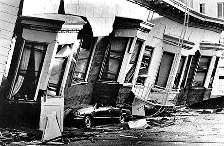
An apartment building in San Francisco’s Marina District was thrown from its foundation and crushed a car in the 1989 magnitude 7.1 earthquake. The Marina District was the scene of voracious fires caused by broken gas lines. Photo by Vince Maggiora.
For further information about earthquakes, please see reports below in the Earthfiles Archives:
01/03/2006 — Antarctic Earthquakes and Edgar Cayce Pole Shift Prediction
08/18/2005 — Unusual Summer Swarm of Arkansas Copperheads
03/10/2005 — Juan de Fuca Ridge: 4,000 Small Quakes West of Vancouver Island, Feb. 27 – Mar. 4.
02/04/2005 — Swarms of Earthquakes in Ecuador and Nicobar and Andaman Islands – A Connection?
01/07/2005 — 9.0 Sumatra Earthquake Update
09/27/2004 — Earthquake Swarms At Mt. St. Helens, Washington
12/13/2003 — Yellowstone Is Still An Active Volcano
10/05/2003 — Part 2 – Cuban Megaliths and the Atlantis Question
09/24/2003 — Part 1 – Update On Deep Water Megalithic Stones and Structures Near Western Cuba
09/19/2003 — Yellowstone Park – Will There Be Another “Super Volcano?”
09/02/2003 — Updated – Astronomers Don’t Think Asteroid Will Hit Earth in 2014
08/30/2003 — Volcanic and Seismic Threats to Northwest U. S.
10/22/2002 — U. S. DOD Satellites Detected Explosion of Siberian Bolide
10/19/2002 — Shifting Time Lines and Earth’s Destiny?
07/10/2002 — Update About Cuba Underwater Megalithic Research
12/15/2001 — Are Carolina Bay Craters Linked to Atlantic Ocean Impact and Sinking of Atlantis?
12/01/2001 — 1200 B. C. – What Caused Earthquake Storms, Global Drought and End of Bronze Age?
06/13/2001 — Update on Mysterious Deep Water Sonar Images Off Western Cuba