

“Farewell Airport could have been a forward staging area to bring in equipment and supplies by helicopters to the ‘Square’ that you mentioned.”
- Airline Pilot and Retired USAF Lt. Col.
“The pilot told my dad the Alaska site was ‘every bit as hush hush as the Manhattan Project.’ ...The pilot also told him that it was not a nuclear device; it was not made by man; nobody is supposed to know this place even exists. ...This thing is some kind of power generator and it’s thousands of years old, it’s made out of stone like a pyramid. They don’t know where it came from, who made it or how it works. But it can generate enough power to power the whole North Slope, all of Alaska, and probably the whole country of Canada!”
- Bruce L. Pearson, New Jersey
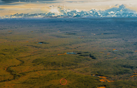
Reposted March 24, 2019 - November 30, 2012 Anchorage, Alaska - In my ongoing efforts to understand if the alleged underground and ancient “dark pyramid” in Alaska could be true, Earthfiles hired Alaskan aerial photographer Frank Flavin to fly in a helicopter on September 26, 2012, over the “green square” latitude/longitude discovered in Google Earth by a retired Navy Captain and described in earlier Earthfiles reports that include:
© 1998 - 2026 by Linda Moulton Howe.
All Rights Reserved.