“The Air Force is trying to keep the X-37B secret, but if you have a stopwatch and personal computer, after you have seen it a few times, you can use well-known math to calculate the orbit and predict where it’s going to be.”
- Jonathan McDowell, Ph.D., Harvard Astronomer
The Boeing X-37B unmanned space plane began as a NASA project in 1999, before transfer in 2004 to the Pentagon's Defense Advanced Research Projects Agency (DARPA). Then its mission control was transferred to the USAF Space Command in Colorado Springs, Colorado.
June 23, 2010 Cambridge, Massachusetts - Two months ago on April 22, 2010, at Space Launch Complex 41 at the Cape Canaveral Air Force Station in Florida, there was a launch of America's first unmanned robotic spacecraft.
Click here to subscribe and get instant access to read this report.
Click here to check your existing subscription status.
“Our data revealed an alarming trend.
The majority of snake populations had declined sharply ....”
- C. J. Reading, Ph.D., U. K. Centre for Ecology and Hydrology
June 2010, Biology Letters.
June 23, 2010 Hammond, Louisiana - When the research paper above was first made public in Biology Letters the first week of June 2010, I was startled to learn that the European science team reported that beginning in the year 1998, 64% of the seventeen snake populations around the world that they studied have declined - some as severely as 90% loss - “and none (of decliners) have shown any sign of recovery over nearly a decade since the crash.” Some of those species in decline include the asp, smooth snake from Europe, the Gabon viper, the rhinoceros viper of West Africa and the royal python.
Click here to subscribe and get instant access to read this report.
Click here to check your existing subscription status.
“It doesn't look like any known aircraft I can think of, not a police or military drone, (outside chance it might be a black project craft), so I can't think what else it could be other than something extraordinary ... a true ufo.”
- Kenneth Parsons, Director, British Earth and Aerial Mysteries Society
June 17, 2010 Reading, Berkshire, England - Today Kenneth John Parsons, Director of the British Earth and Aerial Mysteries Society (B.E.A.M.S.), emailed me images photographed around 10:30 PM on Wednesday night, June 16, 2010, of a mysterious aerial object above Reading, England, west of London. Identity of photographer withheld.
Click here to subscribe and get instant access to read this report.
Click here to check your existing subscription status.
“The buffalo's penis and penile tissue had been removed
from inside the buffalo's abdomen with no signs of blood
or struggle inside a locked, metal corral.”
June 13, 2010 Kiowa, Colorado - On October 19, 1994, at 11 AM, Doug Stewart, owner of the Denver Buffalo Co. near Kiowa, Colorado, found one of his buffaloes dead and mutilated. The 3 1/2-year-old male was in a locked metal corral that enclosed twenty-one buffalo. Stewart insisted the buffalo had been alive the night before when he had a veterinarian visit the corral to check on a different diseased animal.
Click here to subscribe and get instant access to read this report.
Click here to check your existing subscription status.
More than 100 million gallons of crude oil from British Petroleum's unplugged drill hole might already have spewed into the Gulf of Mexico. On June 11, 2010, scientists estimated the BP blown-out well a half mile down in the Gulf could have been spewing as much as 2 million gallons of crude a day until the BP cut-and-cap that is now siphoning off some of the gushing oil. [ 35,000 to 60,000 barrels a day = 1.5 to 2.5 million gallons a day.]
“The BP oil spill threatens a number of power plants.
If the water supply for these facilities becomes contaminated
with oil, cooling water systems could be damaged.”
- U. S. Dept. of Energy May 12, 2010 Situation Report
Sea bird covered with British Petroleum oil in June 2010 on Louisiana shore after BP's Deepwater Horizon drilling unit blew up on April 20, 2010, releasing as much as 2 million gallons of crude oil every day up to BP's recent cut-and-cap maneuver that began capturing some of the oil flow. [ 35,000 to 60,000 barrels a day = 1.5 to 2.5 million gallons a day.] Image by Louisiana Dept. of Wildlife and Fisheries.June 12, 2010 Harrisburg, Pennsylvania - At approximately 11:00 PM EDT on April 20, 2010, an explosion occurred aboard British Petroleum's (BP) Deepwater Horizon mobile offshore drilling unit (MODU) located 52 miles southeast of Venice, Louisiana, and 130 miles southeast of New Orleans. Eleven men working the oil rig died. BP was drilling an exploratory well at the time of the incident. By June 11, 2010, scientists trying to give a reality check on how much oil has erupted from the disastrous mile-deep drill hole stunned the U. S. and the world with an estimate as high as 2 million gallons of crude oil a day, turning the Gulf of Mexico into a toxic marineland and destroying the birds, animals and plant life that live in the delicate wetlands bordering the Gulf shores in Texas, Louisiana, Mississippi, Alabama, western Florida and potentially even the east coast of Florida if enough oil gets into the loop current that goes around the southern tip of Florida and back up the East Coast.
Click here to subscribe and get instant access to read this report.
Click here to check your existing subscription status.
“Quite remarkably, planet Earth and Moon will lie precisely between the two Comet McNaught tracks, incoming or outgoing, close to comet perihelion [ July 2, 2010].”
June 11, 2010 Stony Littleton Long Barrow near Wellow, Somerset, England - Last September 2009, a new comet was discovered by Australian astronomer Robert McNaught. This is the 51st comet to bear comet-seeker McNaught's name. And now ten months later as Comet McNaught is finally becoming visible to the naked eye, an unusual crop formation in beans was reported on June 7, 2010, not far from the Stony Littleton Long Barrow near Wellow, Somerset, England. Australian scientist and crop pattern analyzer, Red Collie, thinks there is a link between the new comet and the new bean formation.
Click here to subscribe and get instant access to read this report.
Click here to check your existing subscription status.
“Who, or what, could overwhelm a 1500-pound cow, transport her from the pasture for the various tissue removals, and then return her to a grove of trees without nearby residents hearing or seeing something?”
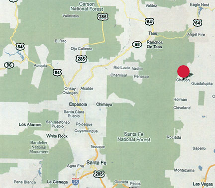
Chacon and Mora, New Mexico, are remote ranching communities marked by the red circle about 50 miles northeast of Santa Fe.
June 10, 2010 Chacon, New Mexico - Biophysicist W. C. Levengood found cellular changes in the plants I sampled from the Chacon, New Mexico, mutilation and “floating” cow site that suggested exposure to microwave frequencies. He had found similar changes at other mutilation sites such as Garnett, Kansas, in June 1994. About that Garnett, Kansas case, biophysicist Levengood's lab report, “Crop Formation Associated with a Cattle Mutilation,” is included in More Information below.
Click here to subscribe and get instant access to read this report.
Click here to check your existing subscription status.
“That cow was being dragged sideways somehow with its legs
touching the ground. The cow's back was moving toward the weird,
loud sound and the cow could not move its legs to get up.”
- Larry Gardea, Carpenter, Chacon, New Mexico
Chacon, New Mexico, is a remote ranching community about 50 miles northeast of Santa Fe.
June 7, 2010 Chacon, New Mexico - Northeast of Santa Fe, New Mexico, across the Carson and Santa Fe National Forests is the small and very rural ranching community of Chacon. Around Chacon rise mountains to 10,000-foot-peaks. There are only a few hundred farm residents who depend on each other to survive. They watch their pastures, the mountains and the sky for any signs of trouble.
Click here to subscribe and get instant access to read this report.
Click here to check your existing subscription status.
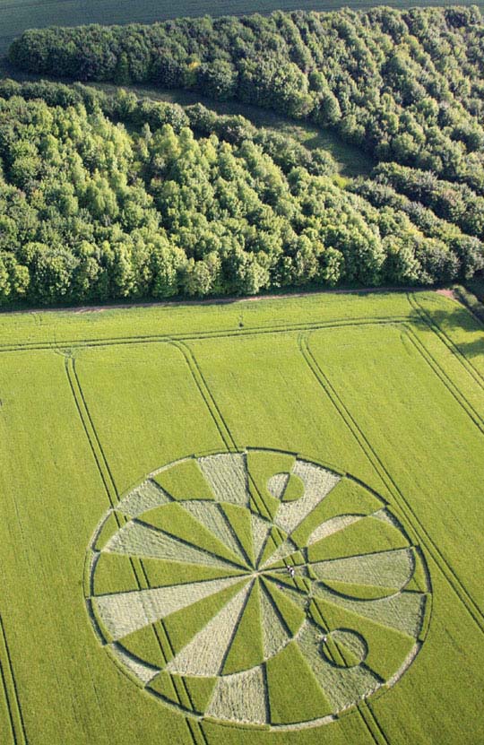
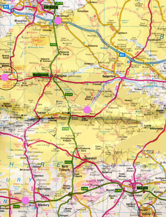
June 4, 2010 Liddington Castle near Swindon, Wiltshire, England - Today I received the following email from Red Collie, an Australian scientist who collaborates with astronomer Mike Reed in the United States and other crop investigators in Italy and elsewhere. For the past few years, Red Collie finds continual references in crop formations to lunar and solar eclipses and other astronomical relationships. When he examined the June 2, 2010, circular pattern in Barley at Liddington Castle, he thinks there is a link to the upcoming June 26, 2010, partial lunar eclipse - and possibly a relationship to the Mayan Long Count calendar.
Click here to subscribe and get instant access to read this report.
Click here to check your existing subscription status.


 June 23, 2010 Hammond, Louisiana
 June 17, 2010 Reading, Berkshire, England - Today Kenneth John Parsons, Director of the British Earth and Aerial Mysteries Society (B.E.A.M.S.), emailed me images photographed around 10:30 PM on Wednesday night, June 16, 2010, of a mysterious aerial object above Reading, England, west of London. Identity of photographer withheld.
![Sea bird covered with British Petroleum oil in June 2010 on Louisiana shore after BP's Deepwater Horizon drilling unit blew up on April 20, 2010, releasing as much as 2 million gallons of crude oil every day up to BP's recent cut-and-cap maneuver that began capturing some of the oil flow. [ 35,000 to 60,000 barrels a day = 1.5 to 2.5 million gallons a day.] Image by Louisiana Dept. of Wildlife and Fisheries.](https://www.earthfiles.com/wp-content/uploads/2017/10/OilSpillBirdOnBackLaJune2010.jpg)