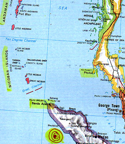
Red bullseye south of Meulaboh and Banda Aceh, island of Sumatra, Indonesia, indicates 9.0 Richter Scale earthquake's epicenter at 8 a.m. Sumatra time on December 26, 2004. The tsunami of a trillion cubic meters of water swamped beaches, including Phuket and the Nicobar and Andaman Islands northwest of Banda Aceh. Yet animals and natives on those nearby islands apparently got to higher ground to survive.
January 7, 2005 Pasadena, California - The 9.0 Indian Ocean earthquake that hit Sumatra, Indonesia, at 8 o'clock Christmas morning was caused by big rocky plates moving over each other more than five miles down at the bottom of the Indian Ocean. Those big chunks of rock were at least 500 kilometers by 150 kilometers wide. That is 311 miles by 93 miles. The Burma Plate slid fifty feet closer to India. Normally the Indian plate has moved only 2.4 inches a year.
Click here to subscribe and get instant access to read this report.
Click here to check your existing subscription status.