Is Cascadia Subduction Zone Most Dangerous in North America? Could A Juan de Fuca Cascadia Earthquake “Destroy A Sizable Portion of the Coastal Northwest?”

“When the next full-margin rupture happens (of the Cascadia
Subduction Zone), that region will suffer the worst natural disaster
in the history of North America. The area of impact will cover some
140,000 square miles, including Seattle, Tacoma, Portland, Eugene
and Salem, Oregon, and Olympia, Washington.”

- The New Yorker, July 20, 2015, “The Really Big One”
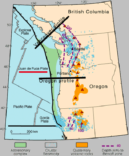
The 90,000 square mile Juan de Fuca Plate is sliding under the bigger North American Plate a few millimeters a year. Where the two plates meet is called the Cascadia Subduction Zone (black line with spikes) that extends from Vancouver south down the coast of Washington, Oregon and northern California. Seismic estimates are that every 250 to 500 years, the plates "unstick" or break their overlap in earthquakes that can range between magnitude 8 and 9. The last big one was 1700. Map by USGS.

August 6, 2015 Seattle, Washington - In the July 20, 2015, issue of The New Yorker was an article that was picked up by the 6 o'clock news throughout North America. The title was, “The Really Big One: An earthquake will destroy a sizable portion of the coastal Northwest. The question is when?”


Click here to subscribe and get instant access to read this report.

Click here to check your existing subscription status.

Existing members, login below:


© 1998 - 2024 by Linda Moulton Howe.
All Rights Reserved.