

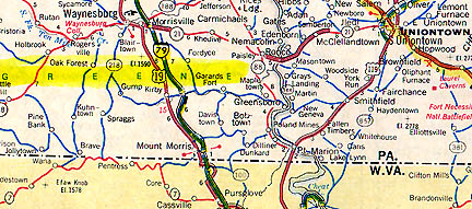
August 1, 2005 Williamsburg, Ohio – On July 3, 2005, a Greene County, Pennsylvania resident and her husband (who have asked for name and town anonymity) saw oat plants in a field which seemed to be laid down in unusually straight 90 degree angles and sections. The couple contacted the local fire department which sent out a hook and ladder truck to see what the field looked like from 75 feet up. From that altitude, the woman took several photographs and sent one to the Coast to Coast AM radio website asking for more information. Eventually two weeks later, a viewer forwarded the photo and sender’s e-mail to Jeffrey Wilson, Director, of the Independent Crop Circle Researchers’ Association (ICCRA). Jeff contacted the couple by e-mail and she arranged to get permission from the farm owner and to meet Jeff and his ICCRA colleagues Charles Lietzau, Ph.D., Delsey Knoechelman and Roger Sugden at the oat field for investigation on July 22, 2005.
Interview:
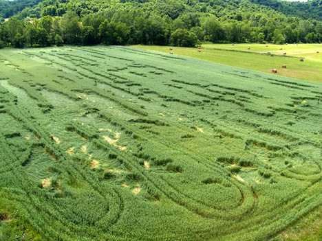
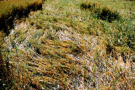
Jeffrey Wilson, Director, Independent Crop Circle Researchers’ Association (ICCRA), Williamsburg, Ohio: “Two of her original photographs from the top of the fire truck ladder show discolored areas the beige color, which are where the swirling of the oat plants was in the highest concentration and most dramatic. In other places, the plants were flattened in a pretty linear direction, although they are also downed in 90-degree perpendicular sections as well. But in the discolored areas, that’s where the greatest swirling, twisting took place.
THAT’S UNUSUAL, ISN’T IT?
Yes, I think it is. I sent you a high resolution photo on that and you can see close-up on the twisted plants.
WHEN I SAW THE TWO PHOTOS FROM THE HOOK AND LADDER, I THOUGHT OF THE RANDOMLY DOWNED WHEAT IN THE TOLLESON SUBURB OF PHOENIX. (See Part 2 of this Earthfiles report and 052605 Earthfiles.)
Yes, in Tolleson there was the similar effect where the plants were almost entirely flattened in between the tramlines. We had some speculation about why that might have occurred out in Tolleson, Arizona, because the farmer had these mounds of dirt that ran the length of the tramlines and was repeatedly flooding the field in between the tramlines. That might have had some effect on those barley plants.
But in this case in Greene County, Pennsylvania, that is not what has happened. There are no mounds of dirt and they aren’t flooding the field. I asked the farmer if he had done any kind of spraying or fertilizing of the field and they had not since planting. So there isn’t any sort of over-fertilizing that knocked the plants down. But it’s really unusual that the flattening would be generally contained within the tramlines.
In both the Tolleson, Arizona, wheat fields and the Greene County, Pennsylvania, oat field, we confirmed there had been elongation of the growth nodes which we do not find in control plants collected away from the downed crop. (See Part 2 of this report for photographs of elongated growth nodes in Arizona investigation.)
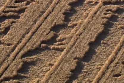
“Pulsed Edge” in Greene County Oats
IN ONE OF THE LADDER SHOTS, IT SHOWS WHAT I CALL A ‘PULSED EDGE’ OF EVENLY SPACED STANDING PLANTS GOING ALONG SOME OF THE LONG STRETCHES OF DOWNED PLANTS. IT IS SOMETHING WE’VE FOUND IN ENGLISH CROP FORMATIONS. IT’S NOT WHAT I WOULD HAVE EXPECTED IN RANDOMLY DOWNED CROP. EVEN THOUGH PULSED EDGES WERE IN AN UNUSUAL RANDOMLY DOWNED WHEAT FIELD IN LINFIELD, PENNSYLVANIA, BACK IN MAY 1992.
Right. We didn’t expect to see the checkerboard in randomly downed either.
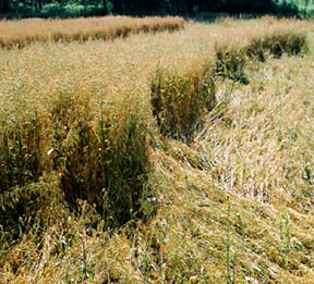
“Checkerboard” Pattern in Greene County Oats
This one section of the photo went on square-by-square for about 80 feet. It continued on and on. That’s what made it really unusual to walk through section by section.
HAVE YOU EVER SEEN A CHECKERBOARD IN ANY OTHER PREVIOUS AMERICAN CROP FORMATION BEFORE?
I can’t say to this effect, no. Not to this size either. It is something we have not come across before.
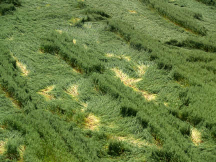
“Hairline Part” In Greene County Oats
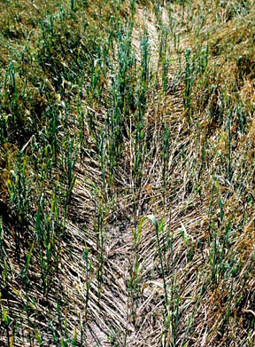
ANOTHER PHOTO IS INTERESTING BECAUSE THE PLANTS ARE LAID DOWN LIKE PARTED HAIR AS WE’VE SEEN IN A VARIETY OF FORMATIONS OVER THE YEARS.
Yes, and in this field in Greene County, Pennsylvania, there were several places in which this effect was laid down in the crop.
Four Layers of Oats Going in Four Different Directions
THERE IS A PHOTOGRAPH IN WHICH ONE OF YOU IS RAISING THE UPPER SURFACE SO YOU CAN SEE THE UNDERNEATH LAYERS. HOW MANY LAYERS DID YOU FIND CRISS-CROSSING EACH OTHER?
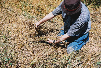
That’s Dr. Charles Lietzau and he is lifting up two layers there and there are two additional layers underneath, all going in a different direction. He’s got his hand pointing the plant layer he has in his right hand is pointing toward the camera. The one he’s got in his left hand is pointing toward the left side of the photo. And the layer directing beneath his hand is 180 degrees from that. And the layer underneath that is pointing away from the camera going into the picture. There are four layers there just in that small section and around him, the plants were flattened in 180 degrees side-by-side.
This again is in a completely different part of the field. So, we saw a really large range of intricate lay patterns in the Greene County, Pennsylvania, randomly downed oat field.
Could Wind and Rain Produce the Greene County Oats Anomalies?
THIS GREENE COUNTY IN PA THAT OTHERS MIGHT CALL ‘RANDOMLY DOWNED,’ IT APPEARS TO HAVE EXTREMELY COMPLEX LAYS IN SECTIONS OF WHAT SOME WOULD SAY WAS RANDOMLY DOWNED, BUT THESE COMPLEX 90 DEGREE OVERLAYS UNDERNEATH AND THE CHECKER PATTERNS AND THE SPLIT HAIR WOULD CONTRADICT THAT THIS WAS JUST WIND AND WATER?
Chuck Lietzau and I, we measured the growth nodes of the plants in Greene County, PA. We took samples across the field and it was to find a control area. There is one area all the way to the far right of the overall photographs that is fairly untouched and we used that as our control area. We measured the flattened plants in that area and we found the nodes in the flattened areas are elongated, which we have not found in either wind damaged or storm damaged fields, or in man-made hoaxed formations. We’ve repeatedly tested manmade formations and that node elongation does not occur. We’ve also tested random wind damaged, weather-damaged fields and node elongation does not occur there either.
So, in this case in Greene County, Pennsylvania, that physical evidence alone tells us this was not just random wind damage. Beyond that, then we’re seeing all these intricate lay patterns that you would normally associate with geometric crop formations. But the overall pattern in Pennsylvania does not seem to be geometric, but contains within what would be considered randomly downed are the 180 degree and 90 degree turns on a dime with the way the plants are flattened. It’s certainly worth studying and seems to be part of a larger overall spectrum of possibilities within looking at crop formations. On one extreme, you have randomly downed events like Greene County and Tolleson, Arizona. Then on the other extreme, we have regular geometric patterns. In between, we have arrangements of circles and single circles by themselves. But I think we have to include randomly downed patterns like Greene County and Tolleson as part of the same effect.
Underground River Flows Beneath
Greene County, Pa. Oat Field
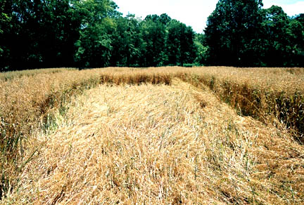
SURROUNDING THE OAT FIELD, ARE THERE ANY OTHER CROPS? I SEE TREES IN ONE OF THE PHOTOS, BUT I WONDERED IF THERE WERE ANY OTHER CROPS NEARBY?
Not still standing. Farmers harvested the hay around there before. Across from the pat field are more hay fields. Adjacent to the oat field, the owner had a natural gas well drilled in the last three to four weeks. Interestingly enough, he said when they were drilling, they hit a really deep, thick layer of clay underneath this area of the field. Underneath the clay is an underground river that runs right beneath the formation. Then he hit a layer of rock. There is also a creek at the back of the field where the treeline is. So, this does fit right into that same pattern of being adjacent to water sources. There are also power lines that run on the opposite side of the road right in front of the field, too.
WATER FLOWING UNDERNEATH, WHETHER IT’S LIMESTONE, CLAY OR WHATEVER, THE PRESENCE OF UNDERGROUND WATER SURE HAS BEEN LINKED TO A LOT OF CROP FORMATIONS.
Why Randomly Downed and Not Geometric Patterns?
DID THE FARMER OR ANY OF HIS NEIGHBORS SEE OR HEAR ANYTHING UNUSUAL ON OR ABOUT JULY 3RD?
No, but the farmer did say that he did notice that the field was flattened after they had a weather front pass through the area. Not a lot of rain, but mostly lightning and gusty winds.
BUT WHY WOULD THE OATS HAVE GONE DOWN IN ALL OF THESE COMPLEX PATTERNS? AND WHY WOULD IT LOOK SO SIMILAR TO THE FIELDS IN PHOENIX THAT ALREADY FROM YOUR TESTS AND LEVENGOOD’S TESTS INDICATE THAT GROWTH NODES WERE ELONGATED FROM SOME KIND OF ENERGY INTERACTING IN PHOENIX AND PROBABLY IN GREENE COUNTY, PA?
Yes, that’s a good question. The Arizona and Pennsylvania randomly downed crops certainly seem to be similar to each other in both their form and in the way they were laid down. Although in Tolleson, the randomly downed fields weren’t associated with rainfall. But the farmer had the same high winds that he thinks were responsible there. Maybe that’s part of the interaction in Pennsylvania. Winds could be providing energy for how some of the plants go down.
WHETHER IT IS DONE BY AN ADVANCED INTELLIGENCE TAKING ADVANTAGE OF NATURAL AND ELECTROSTATIC AND OTHER ENERGIES SYSTEMS ON THE PLANET TO CREATE PATTERNS? OR IS IT ATMOSPHERIC PHENOMENA THAT HAS NOT BEEN DOCUMENTED BEFORE?
It’s up in the air at this point!
THAT IS A PERSISTENT QUESTION: WHY ARE THE FORMATIONS IN ENGLAND SO BEAUTIFUL AND RECOGNIZABLE IN TERMS OF GEOMETRIES? AND IN THE UNITED STATES AND CANADA, CROP FORMATIONS HAVE ALWAYS BEEN ROUGHER. MAYBE THE GREENE COUNTY, PA. FIELD MIGHT HAVE STARTED OUT TO BE AN 8-FOLD GEOMETRY!
Yeah, we’ve debated why you get geometry in some places and in others you get this randomly downed. It could be there is that turbulence or instability in the atmosphere that causes We’ve seen in many cases where you have an almost-geometry. You can see where the geometry should have been and just doesn’t form quite correctly. We’ve seen many examples like that in the U. S.
BIOPHYSICIST W. C. LEVENGOOD HAS FOUND IN HIS PHOENIX RANDOMLY DOWNED WHEAT INVESTIGATION THAT ENERGIES MUST HAVE INTERACTED THERE THAT ARE EXTREMELY UNUSUAL – NOT WHAT WOULD BE LINKED TO IRRIGATION AND WIND. ON TOP OF THAT, HE HAS FOUND MAGNETITE IN THE SOIL, AGAIN SOMETHING WE’VE FOUND OVER AND OVER AGAIN IN CROP CIRCLES, BUT IS NOT EVENLY DISTRIBUTED IN SOIL OUTSIDE OF CROP FORMATIONS. SO, IT WILL BE INTERESTING TO SEE IF THE SOIL FROM THE GREENE COUNTY, PENNSYLVANIA, RANDOMLY DOWNED OATS ALSO HAS MAGNETITE IN IT.
It will be, yes. We did collect both plant and soil samples. It will take awhile to get them analyzed.”
Continued in Part 2 – Biophysicist W. C. Levengood’s Tolleson, Arizona, report.
More Information:
Also, see other Earthfiles reports about crop formations in Earthfiles Archives:
- 07/23/2005 — Mystery of Six Grass Circle Formations in North Carolina
- 07/18/2005 — Garsington, Oxfordshire, U.K. Wheat Formation – Astronomical Orbit?
- 07/01/2005 — U. K. Bicyclist Reports Mysterious, Low Hovering Objects Bending Wheat
- 06/28/2005 — Crop Circles in Poland
- 06/02/2005 — Part 2 – Highly Anomalous Pigment Formation in 2004 Hillsboro, Ohio, Crop Formation
- 06/02/2005 — Part I – Highly Anomalous Pigment Formation in 2004 Hillsboro, Ohio, Crop Formation
- 05/26/2005 — Phoenix Barley Mystery: Apparently Irrigation and Wind
- 05/20/2005 — May 2005 Crop Formation Update in Six Countries
- 05/09/2005 — Mysterious Lights and 2003 Serpent Mound Soybean Formation
- 04/20/2005 — Outer Space Impact At Serpent Mound, Ohio, 256 Million Years Ago
- 04/12/2005 — First 2005 Dutch Crop Circles Reported in Hoeven, Holland Grass
- 10/17/2004 — American Crop Formations: 1880-2004
- 09/22/2004 — Miamisburg and Serpent Mound, Ohio Crop Formations: Geometries Compared
- 09/17/2004 — Updated: Part 1 – High Strangeness in Canadian Cattle Corn
- 09/12/2004 — Part 2 – High Strangeness in Canadian Cattle Corn
- 09/10/2004 — Update on Miamisburg, Ohio, Corn Pictogram – Balls of Light?
- 09/05/2004 — Part 2 – Hillsboro, Ohio Corn Plant Anomalies
- 09/04/2004 — Hillsboro, Ohio Corn Formation – High Strangeness in Soil and Plants
- 09/02/2004 — Updated Photos: Big, Impressive New Corn Formation in Miamisburg, Ohio
- 08/29/2004 — Another Pictogram in Poland
- 08/28/2004 — Cow Mutilation and Loud, Unidentified Sound in Farnam, Nebraska
- 08/12/2004 — Circles in Belgium and Holland
- 08/10/2004 — Updated Aerial Photos of West Overton, Wiltshire “Serpent”
- 08/09/2004 — Pictograms in Poland
- 08/03/2004 — Crop Formations: Fifteen in Southern England Since July 20, 2004.
- 07/26/2004 — Crop Circles in Tilden, Wisconsin Oats and 90-Degree Angles in Litchfield, Minnesota Barley
- 07/25/2004 — 2004 Canadian Crop Formations: Scorched Soybeans and “Dirt” Pattern in Barley
- 07/24/2004 — Part 2: Crop Formations and Mysterious Lights in Wiltshire, England, July 2004
- 07/24/2004 — Part 3 – Crop Formations and Mysterious Lights in Wiltshire, England, July 2004
- 07/15/2004 — Updated: Part 1-Beyond Hillsboro, Ohio, More Corn Down in New Milford, Connecticut
- 07/13/2004 — Updates on Spanish Fork, Utah Barley Formation
- 07/07/2004 — Fourth 2004 Crop Formation in Poland Has Multiple Parts
- 07/06/2004 — Additions to Spanish Fork, Utah Formation and Mysterious Lights Seen
- 07/06/2004 — Mysteriously Downed Oat Plants in Eagle Grove, Iowa, and Downed Corn in Hillsboro, Ohio
- 07/04/2004 — Crop Formation in Spanish Fork, Utah
- 06/17/2004 — More 2004 Holland and Poland Crop Formations
- 06/16/2004 — England: 2004 Crop Formations and 2003 Research
- 06/03/2004 — Updated – Second 2004 Pictogram Crop Formation in Poland
- 06/02/2004 — 2004 Peach Orchard, Arkansas Crop Formation
- 05/24/2004 — Biophysicist W. C. Levengood’s Crop Circle Reports Available for First Time On Internet
- 05/22/2004 — 2004 Overview of Crop Formations in Six Countries
- 05/17/2004 — Updated – Crop Formation Reported in Zabno, Poland
- 05/11/2004 — An Extraordinary Photograph in A Dutch Home
- 05/09/2004 — 2003 English Crop Formations on Documentary DVDs
- 04/14/2004 — Light Anomalies in Photos of Conondale, Australia Grass Circles
- 01/10/2004 — Strange Unidentified Aerial Objects in Indiana and Pennsylvania
- 12/05/2003 — Diatonic Ratios and Seed Changes in 2003 California Wheat Circles Rule Out Hoax?
- 11/01/2003 — Another Soybean Formation in Ohio
- 10/17/2003 — 2003 “UFO Flap” in Ohio
- 10/10/2003 — Updated – Ohio Hunter’s “Deer Camera” Photographs Mysterious Glowing Disk
- 10/03/2003 — Part 2 – Military Interest in Serpent Mound and Seip Mound Formations?
- 10/02/2003 — Part 1 – Another Soybean Formation Near Seip Mound in Ohio
- 09/12/2003 — Second Ohio Soybean Formation Is Manmade – Special USAF Investigation Unit Involved?
- 09/06/2003 — Part 2 – Unusual Soybean Formation Near Serpent Mound, Ohio
- 09/05/2003 — Part 1 – Unusual Soybean Formation Near Serpent Mound, Ohio
- 09/03/2003 — Helicopter “Attacks” Wiltshire, England, Residents At Knap Hill on August 26, 2003
- 08/29/2003 — Part 1 – Why Do Military Helicopters Focus On Crop Formations?
- 08/29/2003 — Part 2 – After August 10, No Crop Formations Except in Canada?
- 08/23/2003 — Fourteen Crop Formations in Canada
- 08/05/2003 — Field Notes from Morgan’s Hill Crop Circle
- 08/01/2003 — Field Notes About English Animal Mutilations
- 07/21/2003 — Strange Orange Lightning and A Sampling of Recent English Crop Formations
- 07/19/2003 — Update – Defiance, Missouri T-Pattern Cut in Saplings
- 07/17/2003 — Land Surveyor Comments About Ogbourne St. George, U.K. Crop Formation
- 07/16/2003 — Unusual Details in Dutch Crop Formations
- 07/11/2003 — Part 2 – Unusual Cylindar-Shaped Cloud Seen Night Before Dutch Crop Circles Discovered
- 06/27/2003 — Part 2 – Mysterious Lights and Fourteen Crop Formations in Italy
- 06/27/2003 — Part 1 – Mysterious Lights and Fourteen Crop Formations in Italy
- 06/13/2003 — Updated: Fractal Crop Formation in Knobel, Arkansas
- 05/26/2003 — East Sussex, England Has Third 2003 Crop Formation
- 05/20/2003 — More 2003 Crop Formations in Germany
- 05/10/2003 — Tree Formation in Defiance, Missouri
- 05/02/2003 — First 2003 English Crop Formations
- 04/29/2003 — Comparison Between First 2003 and 2002 U. K. Crop Formations
- 04/26/2003 — First 2003 U.K. Crop Formation Near Petersfield, Hampshire
- 12/07/2002 — Evolution of Crop Patterns Near Britain’s Chilbolton Radio Telescope , 1999 – 2002
- 11/05/2002 — Canadian Crop Circles and Mysterious Lights in Saskatchewan
- 10/03/2002 — Part 3 – 2002 Crop Formations In Canada
- 10/01/2002 — Part 2 – September 2002 Maize Circles Update: Canada
- 09/28/2002 — Part 1 – September 2002 Maize Circles Update: England
- 09/02/2002 — Blue Lights and Helicopters in Wiltshire’s East Field
- 08/31/2002 — One ET Experiencer’s Reaction to the Winchester Formation
- 08/24/2002 — Crop Formation Update: Canada
- 08/19/2002 — Winchester, Hampshire Circular Code Analysis – UPDATED
- 08/18/2002 — Another Face and Code Appears in Hampshire, England – UPDATED
- 07/25/2002 — Strange Stem Anomalies in New Dutch Crop Circles
- 07/20/2002 — Mysterious Lights Seen Above Field Where Nautilus Formation Emerged
- 07/13/2002 — More Crop Formations in Holland and Germany
- 07/12/2002 — New Crop Formation in England
- 07/06/2002 — Stonehenge 4th of July Formation Echoes Hackpen Hill 1999 4th of July Spiral
- 06/26/2002 — Part 1 – New Crop Formations in England, Holland and Germany
- 06/04/2002 — New 2002 Crop Formations in Wiltshire and Sussex, England
- 05/23/2002 — Third 2002 Crop Formation in Germany Near Giant’s Stone
- 05/11/2002 — First 2002 Crop Formation In Wiltshire, England
- 05/09/2002 — More Orange Triangular Aircraft Over Red Deer, Alberta, Canada
- 05/04/2002 — Two Crop Formations Near Kassel, Germany
- 11/17/2001 — Mysterious Lights in Hessdalen, NorwayAre “Thermal Plasmas of Unknown Origin”
- 10/27/2001 — Another Orange Triangle Near Red Deer, Alberta, Canada
- 10/10/2001 — Update On Unique British Crop Formations
- 09/27/2001 — A Scientific Report About Milk Hill and Chilbolton “Face” and “Code”
- 09/22/2001 — Huge Hexagram Crop Formation in Red Deer, Alberta, Canada
- 09/19/2001 — Part 2 – Gog Magog Hills, Cambridge, England – Two Unusual Crop Formations
- 09/18/2001 — Part 1 – Gog Magog Hills, Cambridge, England – Two Unusual Crop Formations
- 09/07/2001 — Third Case of Pure Hemoglobin at Bull Mutilation
- 08/30/2001 — Chilbolton Observatory – What Does It Do?
- 08/25/2001 — Are Crop Formations at Chilbolton Observatory A Response to 1974 Earth Transmission?
- 08/22/2001 — Milk Hill 2001 – 409 Circles, Most For Any Crop Formation So Far
- 08/09/2001 — Crop Formation in Holland Changes with Researchers Present
- 06/16/2001 — Beyond Stonehenge with Astronomer Gerald Hawkins
- 06/06/2001 — New Crop Formations Reported in Serbia and U. K.
- 05/31/2001 — More Crop Formations in England
- 05/21/2001 — Part 2 – New Crop Formations in Holland, Germany and England
- 05/19/2001 — Part 1 – New Crop Formations in Holland, Germany and England
- 09/30/2000 — Unidentified Moving Spiral of Light Photographed in Crop Formation
- 08/27/2000 — Crop Circle Reports from Whitefish, Montana – Updated Photos
- 08/26/2000 — Pulsing, Jumping Light in West Stowell, England Field
- 08/23/2000 — Intelligence Sensed In Mysterious Lights Associated With Crop Formations
- 08/20/2000 — Crop Formations In North Dakota
- 08/19/2000 — White Balls of Light and Helicopter Videotaped in Woodborough Hill Field
- 08/17/2000 — Mysterious Light Near Woodborough Hill Night Before August 13, 2000 Formation
- 07/16/2000 — Multiple Crop Formations Same Day in Wiltshire and Hampshire, U. K., July 16, 2000
- 07/09/2000 — New Book about Ancient Sites of Wiltshire, England
- 07/06/2000 — Extraordinary U. K. Crop Formations
- 06/17/2000 — Army Helicopters Damage East Field, Wiltshire Crop
- 06/11/2000 — Two New Crop Formations at Silbury Hill
- 05/30/2000 — Crop Formations In Germany, May 2000
- 01/16/2000 — Crop Circle Mysteries – A New Book
- 11/30/1999 — A New Crop Formation In Marion, New York and Crop Research Updates
- 11/18/1999 — Short Environmental Updates
- 10/29/1999 — A New Book About Crop Circles
- 09/29/1999 — Crop Formations Continue in Canada
- 09/21/1999 — 1999 Summary of Crop Formations in Canada and Latest 9/21/99 Edmonton Circles
- 08/15/1999 — More Mid-August 1999 Crop Formations in Wiltshire, England
- 08/01/1999 — 1999 Crop Circle Update from Wiltshire, England
- 07/22/1999 — Cherhill, England, New 1999 Crop Formation
- 07/15/1999 — Brentwood, Tennessee Crop Formation and New U.K. Photos by Peter Sorensen
- 06/27/1999 — New 1999 U. K. Crop Formations Photographed by Peter Sorensen
- 06/07/1999 — 1999 U.K. Crop Circle Update with Photographer Peter Sorensen
Websites:
http://www.cropcircleconnector.com
http://www.kornkreise-forschung.de
http://www.cropcircleresearch.com
http://www.temporarytemples.co.uk
http://www.CropCircleAnswers.com
http://www.ukcropcircles.co.uk/?page=home
© 1998 - 2025 by Linda Moulton Howe.
All Rights Reserved.