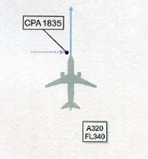
“The Captain perceived an object pass within a few feet above the aircraft. It could best be described as cigar/rugby ball-like in shape, bright silver and metallic-like in construction.”
- Page 87, U. K. Airprox Board Report, January 5, 2014
“We still don’t know what it was, but it was there.”
- Bremen police spokesman, January 6, 2014
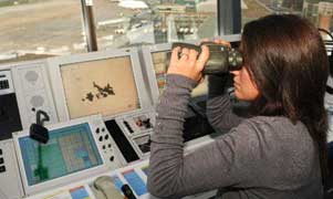
Unidentified aerial object making a loud noise was seen from Germany's Bremen air traffic control tower. Image by DPA.
January 10, 2014 London, England and Bremen, Germany - Six months ago on July 19, 2013, at 6:35 PM local London time in England, a Captain of an A320 airbus was flying at 34,000 feet about 20 miles west of the Heathrow Airport over the Berkshire countryside. According to a recently released U. K. Airprox Report No. 201308:
Click here to subscribe and get instant access to read this report.
Click here to check your existing subscription status.
— “My father thought his house was being hit with a HUGE close-fired military projectile. He said 5-inch 54 artillery shell, to be precise!”
- Residents between Edmonton and Columbia, KY, south of Louisville, Jan. 6, 2014
—“For the second morning in two weeks, I was awakened today by a loud boom. I have lived in this Toronto area for 20 years and temperatures have been much lower than now WITHOUT any reports of frost quakes.”
- Toronto resident on Jan. 7, 2014
January 9, 2014 Albuquerque, New Mexico - From December 2013 to January 8, 2014, Earthfiles received dozens more mysterious loud boom reports and one eerie trumpet/horn multiple earwitness report from Milton, Vermont. This mysterious boom and horn phenomenon has been reported since at least January 2011, and throughout all months of each year, contradicting the 2013 winter speculation of rare “frost quakes” in Toronto and elsewhere caused by extremely cold polar vortex temperatures.
Click here to subscribe and get instant access to read this report.
Click here to check your existing subscription status.
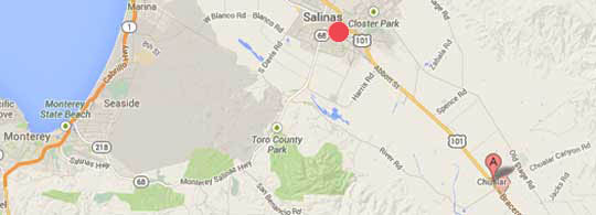
Chualar (CHOO-ah-lahr), California, is 11 miles southeast of Salinas. Chualar Canyon Road runs southwest to northeast through Chualar. The barley pattern was oriented southeast to northwest in the field with a telephone pole at the southern center of the pattern.36 degrees 35' 03" N 121 degrees 28'23" W 250 feet in diameter.
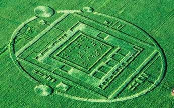
– “What struck me in walking on to the plowed Chualar barley pattern on January 2nd was finding the smooth bends of the crop flat at the soil level like the ‘magic bends’ of English crop formations.”
- Shawn Randall, Crop Formation Researcher, Woodland Hills, Calif.
– “On July 8, 2014, 192 days from December 28, 2013, when the pattern was first discovered - in the inner solar system Earth will be at the 1 o'clock position , Venus will be at the 9 o'clock position and Mars will be at the 2 o'clock position.”
- Mark Wood, U. S. Naval Flight Officer Captain
Chualar (CHOO-ah-lahr), California, is 11 miles southeast of Salinas. Chualar Canyon Road runs southwest to northeast through Chualar. The barley pattern was set a little southeast to northwest in its orientation in the field with a telephone pole at the center south end.
Echelon Security in San Jose, California, on Tuesday, December 31, 2013, confirmed for Monterey County Herald reporter Phillip Molnar that Echelon security guards were hired on Saturday, December 28, 2013, to protect the barley pattern in the field after it first appeared that morning. Chualar residents told field researchers Jeff Krause and David Mendez that dogs barked all night before the pattern appeared and later that people with ropes were measuring in the pattern on Sunday, December 29, 2013.
Click here to subscribe and get instant access to read this report.
Click here to check your existing subscription status.
“I am a 30-year veteran storm spotter/chaser, amateur radio operator and have a solid science background. I have never heard anything exactly like this with this type weather conditions.”
- Resident, Flora, Illinois, December 27, 2013, 6 - 9 PM Central
“The sound was like a horn/trumpet sound, which went off three times.”
- Resident, Milton, VT, December 24, 2013, 2:10 AM - 2:45 AM
“Heard loud boom in Newmarket at 11 PM. Thought tree had fallen on house.”
- Nicole Mortillaro, Newmarket near Toronto, Canada, December 24, 11 PM
“To my dad, the sounds were coming from ‘Up and above,’ but to me (from upstairs) the sound seemed to come from below.”
- Southern Illinois resident, December 21, 2013
Updated Map: Flora, Illinois (Google marker) is only a few miles northeast of Sesser, Illinois (red circle SE of St. Louis) where several loud booms were heard on December 21, 2013 (see report below). Then a week later on December 27, 2013, near Flora and Salem , Illinois, between 6 and 9 PM Central, there were also several loud booms like thunder, “but radars from three different sites showed no storm or precipitation activity.”
Click here to subscribe and get instant access to read this report.
Click here to check your existing subscription status.
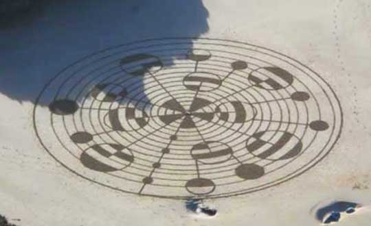
“This sand pattern (spiral) seems to show an astronomical theme, with some kind of binary computer code in its largest circles.”
- Red Collie, retired geneticist, Sydney, Australia
“The Albuquerque 8-ring pattern appeared to be sustained in dust by an electrostatic charge on the window.”
- Albuquerque Resident
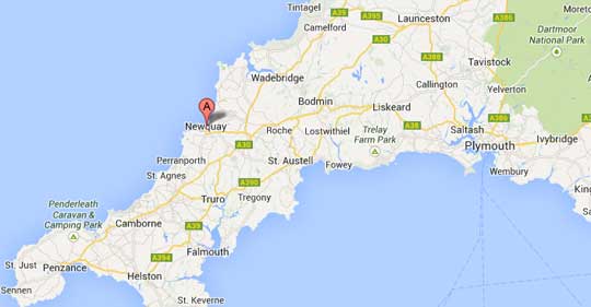
December 23, 2013 Watergate Bay Beach, Newquay, Cornwall, U. K. and Albuquerque, New Mexico - On the southwestern coast of Cornwall at a small beach community called Newquay, there were once up to fifteen pre-historic barrows known as The Barrowfields. But now only a few remain from burials 3,500 years ago. The first settlements were Iron Age hill forts and iron mines.
Newquay, Watergate Bay Beach, Cornwall County, U. K., has two miles of sand along the Celtic Sea in southwestern British Isles.
December 8, 2013 - Beach Sand Spiral Mystery
Watergate Beach, Cornwall, U. K.
On December 8, 2013, at the seaside town of Watergate Bay Beach in Newquay, Cornwall County, United Kingdom, a woman named Karen saw an intricate spiral in the beach sand, photographed it and put it on Facebook. At first, Karen thought the creator of the pattern was Cornish sand artist Tony Plant, but when he was asked, he said he did not know who made the pattern.
Mysterious sand spiral with intricate overlay of binary code circles at Watergate Bay Beach in Newquay, Cornwall County, U. K., on December 8, 2013. Image by Karen, posted on Facebook.
Click here to subscribe and get instant access to read this report.
Click here to check your existing subscription status.
“I think given the type of radiation that causes certain biological damage,
we're dealing with something exotic, something that serves a purpose that every-day-humans on this Earth have no idea is capable of being done.”
- Pat Frascogna, Esq., representing John Burroughs
“The well-reported Rendlesham Forest/Bentwaters event is an example where it might be postulated that several observers were probably exposed to Unidentified Aerial Phenomena (UAP) radiation for longer than normal UAP sighting periods.”
- Page F-4, ANNEX F, “Unidentified Aerial Phenomena in the UK
Air Defence Region: Executive Summary, Scientific & Technical
Memorandum - No. 55/2/00,” Ministry of Defence, December 2000
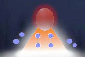
Computer illustration of sketch by John Burroughs of lights he encountered in Rendlesham Forest around 3 AM, December 26, 1980, when he was a USAF Airman 1st Class in the 81st Security Police Squadron C Flight at Bentwaters AFB, U. K. near Woodbridge. He said, “The lights were red and blue, the red one above the blue ones, and they were flashing on and off.” Artwork by John Rackham.
December 20, 2013 Jackson, Mississippi, and Sedona, Arizona - I talked with John Burroughs’s attorney, Pat Frascogna, about the possible link between anomalous radiation in Rendlesham Forest and injury to John’s heart and other damage such as the cataract in his left eye.
Click here to subscribe and get instant access to read this report.
Click here to check your existing subscription status.
“I think what Edward Snowden has done for us is to tell us something that perhaps we should have realized before he came along, which is that we have to have a debate about intelligence power in a post-911 world. How much do we want? How much do we not want? And where do protection of civil liberties fall in that debate?”
- Wesley Wark, Ph.D., Public and Int'l. Affairs, Univ. of Ottawa, Canada
Top: NSA's official seal. Bottom: badge of Communications Security Establishment Canada (CSEC).
December 20, 2013 Toronto, Canada - On December 9, 2013, the Canadian Broadcasting Company's News division known as the CBC received exclusive permission from Glenn Greenwald working with American whistleblower Edward Snowden to release another NSA top secret document that reveals Canada had set up covert spying posts around the world for the American National Security Agency. The CBC redacted - blacked out - portions of the documents on its own, but most of the content is quite clear. Subject: NSA Intelligence Relationship with Canada's Communications Security Establishment Canada (CSEC). “NSA and CSEC cooperate in targeting approximately 20 high-priority countries. .. The intelligence exchange with CSEC covers worldwide national and transnational targets ... and has opened covert sites at the request of NSA.”
Click here to subscribe and get instant access to read this report.
Click here to check your existing subscription status.