How Old Is China’s “Area 51”?

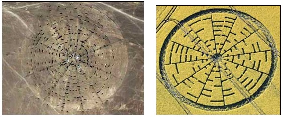
“The ‘Chinese desert disc’ - some people are comparing it to the Wilton Windmill 2010 crop picture, which shows a series of concentric rings, each coded in-to-out radially in 8-bit ASCII.”

- Horace Drew, Retired Geneticist, Sydney, Australia

Left: Unusual feature in China's “Area 51” is a 12-spoke disc with large, white airplanes at the center about 9 miles (14 km) east of the “air strips” (image below). China disc image by Google Earth,  see coordinates in report below.  Right: Compare to 12-spoke crop formation that had  8-bit ASCII binary code reported May 22, 2010, in yellow flowering oilseed rape near the Wilton Windmill in Wiltshire, England. Aerial photograph © 2010 Lucy Pringle.
Left: Unusual feature in China's “Area 51” is a 12-spoke disc with large, white airplanes at the center about 9 miles (14 km) east of the “air strips” (image below). China disc image by Google Earth, see coordinates in report below. Right: Compare to 12-spoke crop formation that had 8-bit ASCII binary code reported May 22, 2010, in yellow flowering oilseed rape near the Wilton Windmill in Wiltshire, England. Aerial photograph © 2010 Lucy Pringle.

“I am a retired engineer doing research with Google Earth. I analyzed image of the ‘Chinese Airport.’ The total outside perimeter of the left (west) airport is 22,360.6 feet, somewhat precisely the square root of 5.
The outer perimeter of the dark section is 22,360.6 / 16 / A where A= E -1 = 1.718281828, the fractal portion of natural log base E.  I seriously doubt anybody in modern times would design anything like that.”

- J. D. Branson, World-Mysteries.com

Two “airstrips” described by retired engineer, J. D. Branson, as 22,360.6 feet long in the China “Area 51” large terraformed region that extends for 20 miles southwest of the Great Gobi Desert A  near ancient Dunhuang and about 200 miles west of China's Jiuquan Satellite Launch Center. Image by Google Earth.

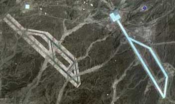
November 19, 2011   Dunhuang, Gansu Province, China - The first images called “China's Area 51” began circulating on the internet and in emails around November 7, 2011. Speculation was they might be geometric targets for satellite calibration. But others argue there are unusual mathematical relationships in the 20-mile wide terraformed complex. The location of the mysterious shapes are southwest of Great Gobi Desert A, Gansu Province, surrounded by a vast region of unpopulated land. Mongolia is to the north and the nearest town is Dunhuang, established in 111 B. C. as a frontier garrison outpost by the Han Dynasty Emperor Wudi. Today's population is 188,000.


Click here to subscribe and get instant access to read this report.

Click here to check your existing subscription status.

Existing members, login below:


© 1998 - 2024 by Linda Moulton Howe.
All Rights Reserved.