Updated: Compare Google Map Street View “Lens Flares” to Historic UFO Images
“Both UFO images are definitely lens flares. Their tops point
directly at the sun, and both have those flarey, balloon-like
diffraction patterns under them.”
- Daniel, Professional Photographer
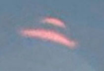
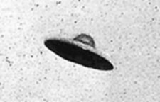
Top: Unidentified aerial object in Acoma Pueblo, New Mexico, 2012 Google Map Street View. Bottom: Photo, July 31, 1952, Passoria, New Jersey. Photo source: UFOEvidence.org.
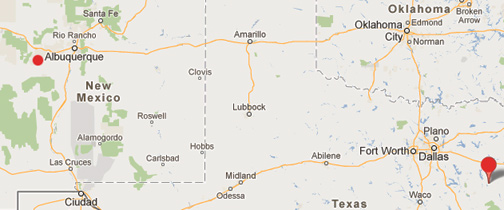
Jacksonville, Texas, is a town of about 15,000 people southeast of Dallas in Cherokee County (lower right red circle). Acoma Pueblo in New Mexico is about 60 miles west of Albuquerque near the El Malpais National Monument (upper left smaller red circle) with a population of about 5,000 Native Americans, who have continuously occupied the pueblo for more than 800 years. The distance between the two sites is 845 miles.
Updated: October 2, 2012 Albuquerque, New Mexico - Recently on September 28, 2012, ABC's Good Morning America reported: “UFO or Lens Flare in Google Street View? You Decide” This was the network follow up to its ABC affiliate KLTV 7's September 26, 2012, East Texas report, “Caught on Tape: UFO On Google Maps? Strange Sight Caught in Sky.”
Click here to subscribe and get instant access to read this report.
Click here to check your existing subscription status.