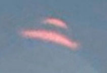
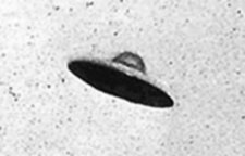
“Both UFO images are definitely lens flares. Their tops point
directly at the sun, and both have those flarey, balloon-like
diffraction patterns under them.”
- Daniel, Professional Photographer
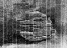
Top: Unidentified aerial object in Acoma Pueblo, New Mexico, 2012 Google Map Street View. Bottom: Photo, July 31, 1952, Passoria, New Jersey. Photo source: UFOEvidence.org.
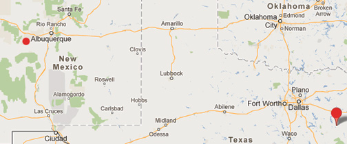
Jacksonville, Texas, is a town of about 15,000 people southeast of Dallas in Cherokee County (lower right red circle). Acoma Pueblo in New Mexico is about 60 miles west of Albuquerque near the El Malpais National Monument (upper left smaller red circle) with a population of about 5,000 Native Americans, who have continuously occupied the pueblo for more than 800 years. The distance between the two sites is 845 miles.
Updated: October 2, 2012 Albuquerque, New Mexico - Recently on September 28, 2012, ABC's Good Morning America reported: “UFO or Lens Flare in Google Street View? You Decide” This was the network follow up to its ABC affiliate KLTV 7's September 26, 2012, East Texas report, “Caught on Tape: UFO On Google Maps? Strange Sight Caught in Sky.”
Click here to subscribe and get instant access to read this report.
Click here to check your existing subscription status.
“Rats exposed to even the smallest amounts of Roundup and NK603 Roundup-tolerant corn developed mammary tumors and severe liver and kidney damage.”
- Prof. Gilles-Eric Seralini, Ph.D., Universite de Caen, France
Large cancerous tumors on white mice fed NK603 Roundup-tolerant genetically modified corn or given water containing Roundup at levels permitted in drinking water. This is the first medical study to examine long-term effects of Monsanto's Roundup herbicide and NK603 Roundup-resistant GMO corn created by Monsanto. CRIIGEN research led by Prof. Gilles-Eric Seralini published September 19, 2012, in Food and Chemical Toxicology.
Food and Chemical Toxicology, September 19, 2012.
September 27, 2012 Oakland, California - According to the U. S. Department of Agriculture's Economic Research Service, in 2011 the percent of corn crops in America that contain some form of genetic engineering is 96% . Most of that genetic engineering is Monsanto's Roundup-resistant corn in which the Roundup NK603 herbicide is built into the plant.
Click here to subscribe and get instant access to read this report.
Click here to check your existing subscription status.
“There is something coming and the fabric of space and time
is getting thin and things are coming through. ... I think it’s going
to be either time travelers or other-dimensional beings.”
- Shane Elam, Commercial Real Estate, Oklahoma City, Oklahoma
September 28, 2012 Oklahoma City, Oklahoma - Shane Elam's last name comes from the ancient Elamites, a bloodline in Shane's family. Elam was to the east of Sumer, in the Zagros Mountains of what we call today Iran. Susa was its capital. The Elamites were one of the first cultures to adapt the Sumerian writing system to fit their own language. The earliest Elamite kings date back to almost 5,000 years ago. Elam was often at war with Mesopotamia's city of Ur.
Click here to subscribe and get instant access to read this report.
Click here to check your existing subscription status.
“The creature slowed down and stood up on its back legs - its back legs were longer than its front legs - and as it stoodup its head turned and it looked straight at us.”
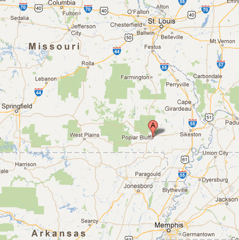
- Jami Ham, Medical Technician, Poplar Bluff, Missouri
Poplar Bluff, Missouri, is 153 miles south of St. Louis not far from the Tennessee border with a population of some 17,000 residents on the Black River.
August 31, 2012 Poplar Bluff, Missouri - In the spring of 1995, farmers in the El Junque rainforest region of Puerto Rico reported finding chickens, rabbits, goats, sheep and even dogs with quarter-inch wide puncture holes that did not bleed, but usually left the victimized domestic animals dead as if the blood had been sucked out of them. That description lead to the name “chupacabras,” which means “goat sucker” in Spanish.
Click here to subscribe and get instant access to read this report.
Click here to check your existing subscription status.
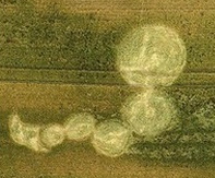
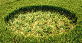
“The recorded effect of severe node bending, when seen on day one, is not the effect of phototropism or similar natural processes. The delivery system employed in the creation of this circle remains a mystery.”
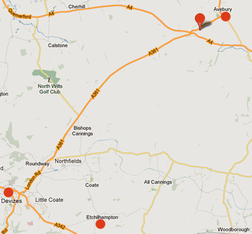
The upper right map pointer is highlighting Knoll Down, Wiltshire, England, not far from the ancient stone circles of Avebury and Europe's tallest manmade mound, Silbury Hill. Southwest by about 12 miles as the crow flies is Etchilhampton Hill (bottom red circle).
August 31, 2012 Wiltshire, England - Mysterious crop circles associated with balls of light moving in the air across fields have been reported in England since at least World War I. The modern age of crop formations emerged in the late 1970s around Warminster, England, and evolved through the 1980s from single circles to simple patterns of a few circles to the astonishing geometries, fractals and other complex patterns from the 1990s into the 21st Century.
Click here to subscribe and get instant access to read this report.
Click here to check your existing subscription status.
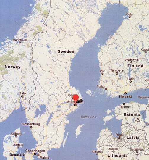
August 28, 2012 Stockholm, Sweden - Today the Swedish EXPRESSEN.SE headlined the following update about the mysterious round object in the bottom of the Baltic Sea that has been investigated the past year by two long-time divers who joined together in the mid-1990s to hunt for sunken treasure in shipwrecks. Peter Lindberg and Dennis Asberg are co-owners of Sweden Ocean Explorer, a Stockholm company devoted to searching for sunken shipwrecks and treasure in the Baltic Sea, who call themselves the Ocean X Team.
Click here to subscribe and get instant access to read this report.
Click here to check your existing subscription status.
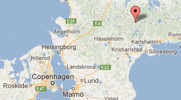
Lonsboda is in southern Sweden northeast of Copenhagen.
From: Lonsboda, Sweden
Subject: Mysterious Boom Sounds
Date: August 26, 2012
To: [email protected]
"Hello!
I was reading your article on the mysterious explosion-like boom's that have occurred in the USA recently. I would like to report another one, but this time in the south of Sweden, near the town of Lönsboda. I would describe the sound as distant, if not underground.
Click here to subscribe and get instant access to read this report.
Click here to check your existing subscription status.
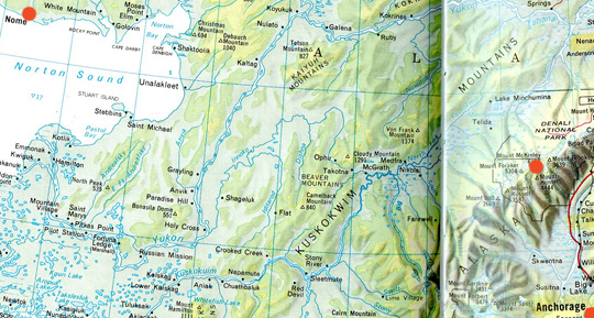
“I don't know if the Purkeypile, Alaska, seismic sensor would identify an underground pyramid structure, but if the requirement is that the anomaly has to be on a straight line connecting the explosion at Lop Nor to the sensor in Alaska, then I think we can check that box as a straight line!”
- Retired U. S. Navy Captain, Navigator/Communicator,
Tactical Coordinator and Mission Commander
Mount McKinley is north of Anchorage. Nome is upper left red circle on Norton Sound west of Mount McKinley. The region between Mount McKinley and Nome is where the large pyramid structure was allegedly found during geophysical studies of the May 22, 1992, Chinese underground detonation of a large nuclear bomb at Lop Nor.
August 3, 2012 Albuquerque, New Mexico - After my Coast to Coast AM broadcast July 26 to 27, I have received many emails concerning aerial discs seen in Alaska skies and the alleged underground pyramid between Mount McKinley and Nome, as well as information about the 1973 remote viewer Pat Price's description of a “UFO base” inside or under Mount Hayes northeast of Mount McKinley. Pat Price was working in a CIA-funded remote viewing program directed by Hal Puthoff at the Stanford Research Institute (SRI) in Palo Alto.
Click here to subscribe and get instant access to read this report.
Click here to check your existing subscription status.
“The TV news showed the whole world and they had it sliced out
where the pyramid was and how big it was in proportion. I mean
the thing was huge in the proportional graph they showed.”
- Douglas A. Mutschler, Chief Warrant Officer, U. S. Army Counterintelligence
Mount McKinley is north of Anchorage. Nome is upper left red circle on Norton Sound west of Mount McKinley. The region between Mount McKinley and Nome is where the large pyramid structure was allegedly found during geophysical studies of the May 22, 1992, Chinese underground detonation of a large nuclear bomb at Lop Nor.
Updated July 30, 2012 Fairborn, Ohio - After my Coast to Coast AM broadcast July 26 to 27, I received the following email from a retired Navy Captain and professional engineer who provides analysis of a large “square” he found in Google maps in which each side of the square measures exactly twice the length of each side of the Cheops Great Pyramid in Egypt.
Click here to subscribe and get instant access to read this report.
Click here to check your existing subscription status.
“My father was 're-recruited' by the military to join a group of other experts to study and work at an underground structure in Alaska that in his words they called the‘Dark Pyramid.’”
- July 27, 2012 email to Earthfiles
“What the geologists said they found in this byline news story (Anchorage TV Channel 13) story was under Alaska, they found a pyramid bigger than the one in Egypt.”
- Douglas A. Mutschler, Chief Warrant Officer, U. S. Army Counterintelligence
Mount McKinley is north of Anchorage. Nome is upper left red circle on Norton Sound west of Mount McKinley. The region between Mount McKinley and Nome is where the large pyramid structure was allegedly found during geophysical studies of the May 22, 1992, Chinese underground detonation of a large nuclear bomb at Lop Nor.
Updated August 10, 2012 / Original Report July 27, 2012 - I continue to receive email from a wide variety of professionals with comments about the possible underground pyramid structure in Alaska between Mount McKinley and Nome said to be larger that the Great Pyramid of Giza in Egypt. One particularly noteworthy email is dated July 27, 2012.
Click here to subscribe and get instant access to read this report.
Click here to check your existing subscription status.