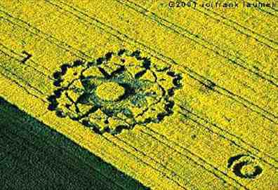
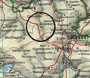
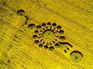
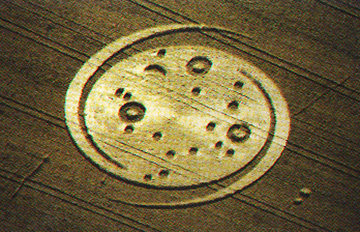
May 19, 2001 Zierenberg, Germany - The fourth European crop formation since April 26 was discovered on Sunday, May 13 at 7:30 a.m. by the farmer in yellow flowering oilseed rape not far from Kassel, Germany in the farming community of Zierenberg. Each year for the past several years from May 1 on, formations have emerged in Zierenberg crops. The sixfold formation in 2001 is one of the most intricate ever to appear in crisp, dense oilseed rape (canola). On either side of the sixfold pattern are "signatures" of an "L" an a crescent ring.
Click here to subscribe and get instant access to read this report.
Click here to check your existing subscription status.
"The vet said there was a 10-inch hole in her digestive tract about 10 inches inside her rectum. He had another doctor confirm it and told us: 'This horse has been mutilated and we cannot save her.'"
- Guy Elford, Calgary, Alberta Resident
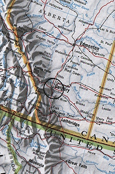
Calgary, Alberta, Canada where law enforcement has had a dozen horse slashing reports since 1980.
May 11, 2001 Calgary, Alberta, Canada - The Canadian Calgary Herald newspaper recently headlined, "Police say horse mutilations likely work of sexual deviate: Investigators examine links in equine attacks." Calgary law enforcement confirm two horse slashings on April 9 and another eight months before on the Guy and Christine Elford residence. A fourth attack killed Tammy Hambrook's pet horse in 1999. Over the past twenty years, there have been at least a dozen similar equine attacks in the Spy Hill of Calgary. Yet, despite the suspicions that a sexual predator is on the loose, no person has ever been arrested and arraigned on a horse slashing charge.
Click here to subscribe and get instant access to read this report.
Click here to check your existing subscription status.
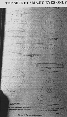
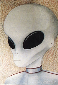
Page 20 of the alleged U. S. government Restricted SOM1-01 Majestic-12 Group Special Operations Manual entitled "Extraterrestrial Entities and Technology, Recovery and Disposal," dated April 1954 by the United States of America War Office. Eight different "extraterrestrial craft" are drawn with a bottom note that reads: "Illustrations in this diagram are gathered from documented sightings in Air Force and Central Intelligence (CIA) and from examination of wreckage collected from various sources years 1947-1953 inclusive." See book Glimpses of Other Realities, Vol. II: High Strangeness by Linda M. Howe.
Ft. Belvoir, Virginia Film Clips of Different Unidentified Aerial Craft
Disc with cupola on top as thick or thicker than disc.
Cigar shape.
"Shoe heel " shape.
Crescent shape.
Triangular shape.
Click here to subscribe and get instant access to read this report.
Click here to check your existing subscription status.
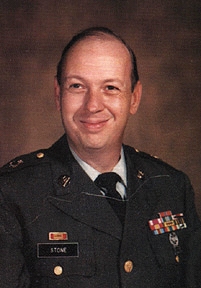
Sergeant Clifford E. Stone, U.S. Army, retired in 1990 to his home in Roswell, New Mexico after more than twenty years as a specialist assigned to investigations of unidentified aerial vehicle crash and retrievals. Photograph courtesy Clifford Stone.
Roswell, New Mexico - In 1997, a book was published entitled U.F.O.s Are Real, Extraterrestrial Encounters Documented by the U. S. Government containing documents assembled by retired U. S. Army Sergeant Clifford E. Stone of Roswell, New Mexico. He served more than twenty years as a specialist assigned to investigations of unidentified aerial vehicle crash and retrievals.
Click here to subscribe and get instant access to read this report.
Click here to check your existing subscription status.
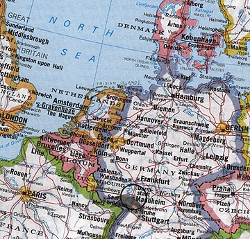
On April 26, 1986 when the Chernobyl, Russia nuclear reactor melted down, radioactivity spread all over Europe. Mannheim, Germany housed about 60,000 American military at the time, including a National Security Agency unit that passed out all the secret military codes. Not far away were the huge American Ramstein AFB in Kaiserslautern and Rhein-main AFB in Frankfurt.
April 21, 2001 El Paso, Texas - Sergio Arellano was born in El Paso fifty years ago, graduated from high school there and then joined the U. S. Army where he earned a degree in transportation. By the end of April 1986 - and after the awful nuclear melt down at a Chernobyl, Russia power plant on April 26, 1986 - Sergio was a Master Sergeant in Mannheim, Germany working in the 28th Transportation Battalion. In 1996, he retired from the Army and returned to his hometown to work for a commercial trucking company.
Click here to subscribe and get instant access to read this report.
Click here to check your existing subscription status.
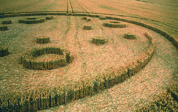
"On August 3-4, 1994, Werner Anderhub from Bern, Switzerland and a friend decided to visit a crop formation at midnight several days after it had been discovered on July 23rd. Researchers called it the "Galaxy" at West Stowell, a little east of Alton Barnes
"As the two men entered at the southeastern corner of the field about 150 meters from the Galaxy, a very large and bright light seemed to come from the ground inside the crop formation and rise into the sky. Werner told Bert Janssen and Janet Ossebaard in their 1999 documentary Crop Circles, The Research, "It was so bright, it lit up the hills in the background. It was bluish-white in color and about as big as the formation, fifty to sixty meters wide. The bright light formed some sort of cloud and it changed shape continuously as it hovered over the formation. After a couple of seconds, it rose at slow speed and disappeared into the darkness. My friend and I were totally flabbergasted!"
Click here to subscribe and get instant access to read this report.
Click here to check your existing subscription status.
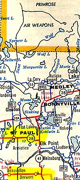
Bull mutilation discovered on October 16, 2000 near Derwent, Alberta, Canada ranch south of St. Paul and the Primrose Air Weapons Base.
October 29, 2000 Derwent, Alberta, Canada - Oscar Jackson had been checking fences on the Saddle Lake Indian Reserve in Derwent, Alberta on October 13 when he last saw the six-year-old Charlais bull alive. The owner, Marshall Kisiak, runs close to 200 head on that pasture. Three days later on October 16, the bull was found dead with a pattern of neat and largely bloodless excisions from his head to his scrotum with no signs of struggle. Fern Belzil of St. Paul raised purebred cattle professionally. Now in retirement, he has taken a serious interest in the cattle mutilation mystery and has investigated several dozen Alberta cases, including this recent bull death. He traveled to Derwent on October 19th to photograph the odd excisions.
Click here to subscribe and get instant access to read this report.
Click here to check your existing subscription status.
“It's totally incomprehensible how the hemoglobin could be removed in the middle of the night out in the middle of a pasture and be separated from all the other cellular components.”
October 16, 2000 Grass Lake, Michigan: W. C. Levengood, Biophysicist and Owner, Pinelandia Biophysical Laboratory, called me in early January 1997, to talk about his examination of black particles that rancher Jean Barton found on one of the several mutilated cattle she and her husband, Bill, have discovered on various pastures of their Red Bluff, California ranch. He read to me from his lab work book about the hard, dark particles found on the chest and testicles of a mutilated bull at the Barton ranch.
Click here to subscribe and get instant access to read this report.
Click here to check your existing subscription status.