“I specifically want Project JEHOVAH director Professor Albert Einstein and Doctor Robert Oppenheimer to inject any useful comments to the briefing as they are most informed on the physics related to the subject.”
- Dwight D. Eisenhower, 34th President of the United States, January 20, 1953 to January 20, 1961
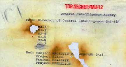
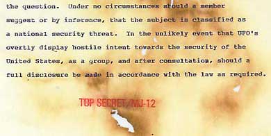
Burned memo, presumably written before assassination of John F. Kennedy on November 22, 1963, when either John A. McCone or Allen W. Dulles were Directors of the Central Intelligence Agency. In the TOP SECRET/MJ-12 red stamped 9-page document, the first page cropped above shows the document is “From: Director of Central Intelligence (MJ-1) to MJ-2 through MJ-7, with reference to: Project MAJESTIC and JEHOVAH (MJ); Project EVIRO; Project PARASITE; and Project PARHELION.”In the burned first page above, under references to Project MAJESTIC and JEHOVAH (MJ), EVIRO, PARASITE AND PARHELION, the writer, who is Director of Central Intelligence (MJ-1), states: “As you must know LANCER has made some inquiries regarding our activities which we cannot allow.” LANCER was the Secret Service classified code name for President John F. Kennedy, as LYRIC was the classified code name for JFK's wife, Jacqueline Kennedy.
August 6, 2008 Albuquerque, New Mexico - On April 20, 2002, I reported an Earthfiles.com entitled Canadian and American Officials in 1950s Collaborated on Study of Unidentified Aerial Disks. See 042008 Earthfiles in Real X-Files Archive. There were two subjects in that Earthfiles report: a Canadian government investigation of UFOs and an American government UFO-related Project JEHOVAH.
Click here to subscribe and get instant access to read this report.
Click here to check your existing subscription status.
“I would presume that the scenario involved is that MJ-1 is dictating this burned memo to a secretary. He, MJ-1, does not want the secretary to know that he is saying, ‘We ought to kill JFK.’”
- Robert Wood, Ph.D., Physicist and Retired Aerospace Manager
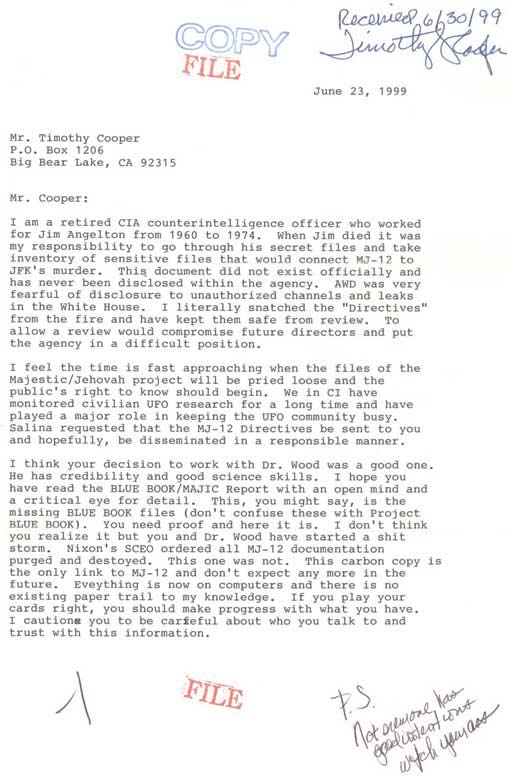
Cover letter with burned memo from leaker who wrote he worked from 1960 to 1974 in CIA counter-intelligence for James Jesus Angleton, Director, CIA Counter-intelligence from 1954 to 1974. After James Angleton died on May 12, 1987, leaker said he pulled this 9-page memorandum from a fire that was burning up Angleton's most sensitive MJ-12 secret files. All images in this report provided by Robert Wood.
Updated August 6, 2008 / August 4, 2008 Newport Beach, California -
Interview:
Robert Wood, Ph.D., Physicist and former Aerospace Manager for McDonnell Douglas Corporation, now retired in Newport Beach, California: “The cover letter was written, in my opinion, by the person who says he worked for James Jesus Angleton in counter-intelligence at the CIA. It amazed me that my name was in the letter. And also, it says ‘ -1 ‘ to the left of the red FILE stamp at the bottom of this letter. That presumably was a way of identifying the leaker. We had other leaked documents from ‘-2,’ which was a different address and different kind of information.
Click here to subscribe and get instant access to read this report.
Click here to check your existing subscription status.
“Right now, we don't know whether finding perchlorate is good news or bad news for possible life on Mars.”
- Peter Smith, Ph.D., Phoenix Lander Principal Investigator
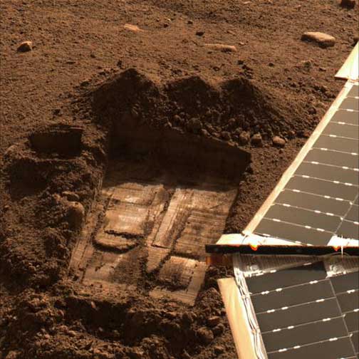
This image shows the trench informally called “Snow White” where the perchlorate has been detected. This image was acquired by NASA's Phoenix Mars Lander's Surface Stereo Imager on Sol 43, the 43rd Martian day after landing on July 8, 2008. Two samples were delivered to the Wet Chemistry Laboratory, which is part of Phoenix's Microscopy, Electrochemistry, and Conductivity Analyzer (MECA). The first sample was taken from the surface area just left of the trench and informally named “Rosy Red” It was delivered to the Wet Chemistry Laboratory on Sol 30 (June 25, 2008). The second sample, informally named “Sorceress” was taken from the center of the Snow White trench and delivered to the Wet Chemistry Laboratory on Sol 41 (July 6, 2008). Image credit: NASA/JPL-Caltech/Univ. of Arizona/Texas A&M.
August 5, 2008 Pasadena, California - Responding to the growing buzz on the internet about suppressed Mars Phoenix Lander data and the White House Science Adviser being briefed on a new and potentially disturbing discovery in the lander's soil analysis, today Phoenix mission scientists spoke and answered questions in an hour phone conference produced by NASA and JPL.
Click here to subscribe and get instant access to read this report.
Click here to check your existing subscription status.
“The one I saw had a longer snout or beak or whatever you want to call it.”
- Sean (last name withheld)
“Lavey Fater saw a surfer bring one to shore, near Ditch Plains. ‘It was hairless and gross. The surfer said he had no idea what it was, but that he threw it in the dunes because he didn't want to be surfing next to it.’”
- Newsday.com
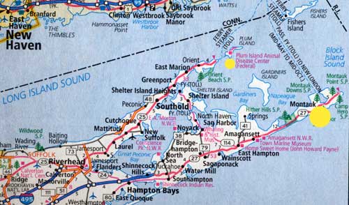
Montauk (large yellow circle) is only 1.5 miles from the Plum Island Animal Disease Center (smaller yellow circle), also known as PIADC, a U. S. Dept. of Agriculture facility “dedicated to the study of foreign animal diseases. Since 1954, the center has had the goal of protecting America's livestock from foreign animal diseases.”
August 3, 2008 Montauk, Long Island, New York - On July 29, 2008, a photo of a strange, unidentified animal that appeared to have a beak, long, thin paws and the body of a dog was posted on the blog Gawker. The location of the dead creature's body was given as Montauk, Long Island, New York, and the photographer was listed as Jenna Hewitt. Jenna and two of her girl friends, Rachel Goldbert and Courtney Fruin. The girls thought they found the creature and took their photograph on or around July 13, 2008.
Click here to subscribe and get instant access to read this report.
Click here to check your existing subscription status.
August 3, 2008 Newport Beach, California - The following documents begin with the cover letter dated June 23, 1999, sent by the alleged CIA counter-intelligence leaker with the 9-page “burned memo” to Timothy Cooper at his Big Bear Lake, California, home.
Click here to subscribe and get instant access to read this report.
Click here to check your existing subscription status.
“As far as I know, this ‘burned memo’ is the only document
that I've ever heard anyone claim could be the authorization
to kill President John F. Kennedy.”
- Robert Wood, Ph.D.,
Physicist and Retired Aerospace Manager
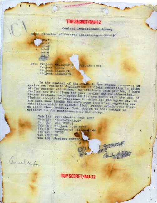
Tab A, TOP SECRET/MJ-12 Central Intelligence Agency memo from Director of Central Intelligence (MJ-1) to MJ-2 through MJ-7 allegedly written in 1961 to 1963 time period. Leaker says he worked 1960 to 1974 in CIA counter-intelligence for James Jesus Angleton, Director, CIA Counter-intelligence from 1954 to 1974. After James Angleton died on May 12, 1987, leaker said he pulled this 9-page memorandum from a fire that was burning up Angleton's most sensitive MJ-12 secret files. Image provided by Robert Wood.
August 3, 2008 Newport Beach, California - In 1993, Robert Wood, Ph.D., retired from his management work at McDonnell Douglas Corporation, a large aerospace company where he had worked since 1953. That was the year he received his Ph.D. in Physics at Cornell University where his focus was theoretical physics and aeronautical engineering. Immediately after graduation, he began working for McDonnell Aircraft Corporation in Maryland, but was drafted into the U. S. Army for two years and was assigned to Aberdeen Proving Ground northeast of Baltimore. For the Army, Bob analyzed the boundary layers of ballistic shells. After completing his draft service, he left as a corporal and returned to McDonnell Aircraft, which on April 28, 1967, merged with Douglas Aircraft to become McDonnell Douglas Corporation.
Click here to subscribe and get instant access to read this report.
Click here to check your existing subscription status.
“Without habeas corpus in the United States today, what we now have is a Fourth Reich, somebody in a position of power - the President, the Attorney General, the head of Homeland Security – can simply point a figure at you and designate you as an undesirable and hence, an enemy combatant, and they can grab you and imprison you and you don’t even get a day in court, much less a lawyer.”
August 1, 2008 Wise County, Texas - Recently I read a new book published in July 2008 that documents surprising links between Adolph Hitler’s Nazi Third Reich (1933 to 1945 empire) in Germany - and America’s banks, business owners, political power-brokers and wars - past and present.
Click here to subscribe and get instant access to read this report.
Click here to check your existing subscription status.
“We found a possible AWAC that maintained an altitude of about 41,000 feet, which is higher than most of your civilian aircraft fly. It was there for the entire time of our radar data and it’s flying figure 8s over the area – going as far as north Texas to as far south as the
northern Austin area.”
- Robert Powell, MUFON Director of Research
“I think the January 8, 2008, Carswell log book was blacked out on the ten F-16s because the military wanted as little known as possible about what their F-16s were doing that day.”
- Glen Schulze, Electrical Engineer and Radar Specialist
Updated: July 29, 2008 Littleton, Colorado - Interviews with Glen Schulze and Robert Powell continue in Part 2 about the discovery of an unknown object that reflected at least 200 skin-paint returns, but was not sending out transponder signals to the FAA radar towers. Further, that unknown aerial object was moving in a straight line between 6:51 PM and 8 PM towards the George W. Bush ranch in Crawford, Texas. Yet, Glen and Robert could not find any radar signals of jet activity responding to that unknown approaching the property of the American President.
Click here to subscribe and get instant access to read this report.
Click here to check your existing subscription status.
“When radar returns on one unknown object (no transponder beeps) did show up in the data from 6:51 PM to 8:00 PM, on our graph it was traveling a straight line headed for Crawford, Texas.”
- Glen Schulze, Electrical Engineer and Radar Specialist
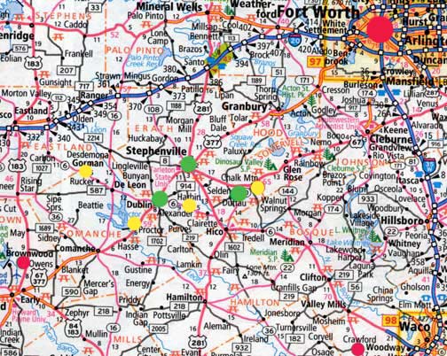
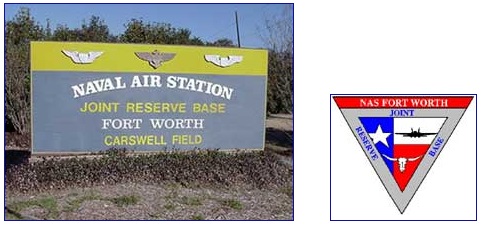
A triangle of three small towns (green) southwest of Fort Worth includes Stephenville, a city in and the county seat of Erath County, Texas, population 14,921 in 2000 census. Dublin, about eight miles southwest, has a population of 3,754. Straight east of Dublin about ten miles is Selden with a full time population of about seven. The Brownwood Military Operations Area (MOA) is further southwest in map's lower left red circle. The red circle in lower right corner of map is Crawford, Texas, ranch home of U. S. President George W. Bush. The Naval Air Station Joint Reserve Base at Carswell Field is five miles west of downtown Fort Worth, large red circle in upper map right. The four yellow circles at Gorman, Proctor Lake, Alexander and Chalk Mountain are UFO eyewitness locations on January 8, 2008, in addition to several other eyewitnesses in the green circles of Stephenville, Dublin and Selden, Texas.Naval Air Station Joint Reserve Base Fort Worth or NAS JRB Fort Worth, also known as Carswell Field, is now home to the U. S. Navy Reserve, U. S. Marine Corps Reserve, U. S. Air Force Reserve, and U. S. Air National Guard. The Carswell military complex is a military airfield located five miles (8 km) west of the central business district of Fort Worth, in Tarrant County, Texas, United States. This military airfield is operated by the United States Navy. The Air Force Reserve Command's Tenth Air Force headquarters and 301st Fighter Wing continue to be based at the installation, as well as the 136th Airlift Wing of the Texas Air National Guard. A number of Marine Corps aviation and ground units are also co-located at NAS JRB Fort Worth. Currently based Air Force aircraft are the F-16 Fighting Falcon and C-130 Hercules. Currently based Marine Corps aircraft are the F/A-18 Hornet and KC-130 Hercules.
July 26, 2008 Littleton, Colorado - Back in early January to mid-February 2008, a series of unidentified aerial lights and strange craft were reported by dozens of eyewitnesses in the Stephenville, Dublin, and Selden region southwest of Dallas/Fort Worth, Texas. One especially active date was January 8, 2008, beginning a few minutes after 6 PM Central with three eyewitnesses sitting on a hill in Selden southeast east of Stephenville and straight east of Dublin.
Click here to subscribe and get instant access to read this report.
Click here to check your existing subscription status.
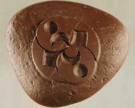
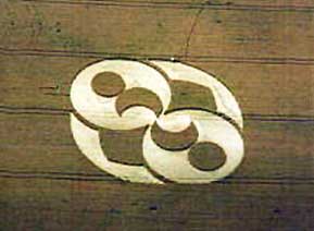
“The pattern is remarkable. Obviously, it is something that took a lot of care and knowledge to produce because this hard, iron-rich sandstone with magnetite is not easily worked.”
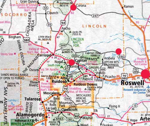
Roswell is larger red circle on far right. Cedar Hill deer hunting trail is smaller red circle on Highway 246 (Pine Lodge Road) just west of Chavez and Lincoln County borders northwest of Roswell. Capitan is middle red circle and Corona is top center of map. Cedar Hill deer trail is 17 miles southeast of the July 4, 1947, crash site between Corona and Roswell.
July 18, 2008 Portales, New Mexico - I contacted the original geologist in Portales who did the first February 2005 energy-dispersive X-ray fluorescence spectroscopy on the rock for Robert Ridge. I learned that all the original test results had been lost a couple of years ago in a computer hard drive crash. So, on Tuesday, July 15, 2008, I drove to Portales, New Mexico, to meet Robert for a second round of testing of the mysterious carved rock at the Physical Sciences Department of Eastern New Mexico University. The Chair of that department is Geology Professor James Constantopoulos, Ph.D., who has taught at ENMU for nearly twenty years. Prof. Constantopoulos began by examining the rock using a binocular microscope.
Click here to subscribe and get instant access to read this report.
Click here to check your existing subscription status.