August 11, 2003 North Down, Wiltshire, England – Yesterday, a new 750-foot-diameter formation in wheat was reported between Morgan’s Hill and Cherhill Down directly east of the four tumuli and 11-concentric-ring formation of July 6, 2003 in North Down. From the air, the pattern contained 61 circles that alternate dark and light – the light being flattened crop and the dark standing. The circles create a 3-dimensional object that has three branches that resemble a hexagonal-structured molecule.
August 5, 2003 Devizes, Wiltshire, England – On Sunday afternoon, August 3, 2003, a new formation was reported at Morgan’s Hill on the other side of the North Down where the four tumuli and 11-concentric-ring formation was discovered on July 6, 2003. The next morning, Monday, I traveled to the formation and was impressed with the springy feeling the crop had under my feet. There, I met up with photographer and video producer, Bert Janssen, who has studied the geometry of crop formations for several years. He has produced two award-winning documentaries, Contact and Crop Circles: The Research. I explained to him that I had counted twenty-eight rays coming off one side of the large central flattened circle and seventy-eight coming off the opposite side. He walked around the top rays and into the large central circle trying to see if the rays lined up with the center “fountain” of wheat. They did not and the formation’s geometric structure became a challenge to understand.
July 31, 2003 Devizes, Wiltshire, England – I arrived in Wiltshire early Tuesday morning, July 29, 2003, after the Glastonbury Symposium and went directly to Woodborough Hill in Alton Barnes. The East Field, beneath Adam’s Grave and Knap Hill, is famous for receiving crop circles over the past decade and was still untouched by patterns. So was the spring barley across the road extending up to the base of Woodborough Hill. I could hear a helicopter, then another, which began circling over Woodborough and then on to the East Field, moved on to West Stowell and back around again. The helicopters were hovering, then lowering down toward the fields and then rising back up again. I had seen these same maneuvers back in August 2000 during one day that seven of us did a night watch at the East Field and watched through a night vision scope as an oval-shaped light jumped from side to side and changed shape into a bright square. (See Earthfiles August 2000.)Click for report.
July 21, 2003 – A sampling of recent formations in Wiltshire and Hampshire counties of southern England where so far, there have been forty-five formations reported in 2003. And an eyewitness report below about strange orange lightning seen from Knap Hill the night before a formation was reported at Windmill Hill on June 22, 2003.
July 18, 2003 Defiance, Missouri Unusual patterns in cereal crops around the world have provoked some people to wonder if the formations are a warning that the Earth’s environment and food supplies are not guaranteed and in fact, might be seriously threatened. The past ten years on Dreamland radio and now Dreamland Online, I have interviewed dozens of scientists about problems in the air, land and sea, including increasing extinctions of plant and animal life. Now comes a new study reported in the journal Science which shows that in only thirty years, the amount of coral reefs in the Caribbean have declined 80% from what they once were.Click for report.
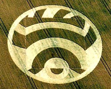
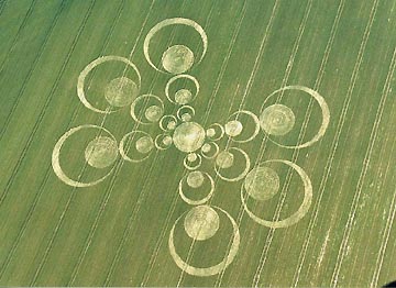
July 17, 2003 Howell, New Jersey After the Ogbourne St. George formation was discovered in Wiltshire, England, on Sunday, June 15, photographer and researcher Lucy Pringle wondered if it could be an 8-fold geometry instead of 6-fold? The reason is the “butterfly wing” distribution of the six arms, rather than an equally spaced distribution of the arms or spokes around the central circle. I was curious and asked professional land surveyor, Vincent Creevy, of Howell, New Jersey, to look at Lucy’s aerial photographs.Click for report.
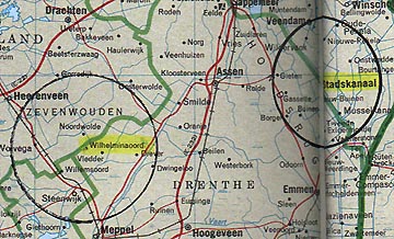
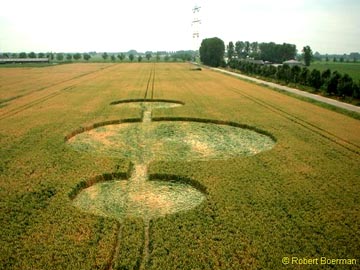
Wilhelminaoord, Drenthe, Holland, was the site of two unusual wheat crop formations discovered by the farmer the morning of July 13, 2003. To the east is Stadskanaal which had formations in 2002 and 2001 that changed over time.
July 16, 2003 Wilhelminaoord, Drenthe, Holland – Yesterday Dutch crop circle researcher, Robert Boerman, who produces the website, www.dcca.nl, received a phone call about two crop circles in the same wheat field near Wilhelminaoord, Drenthe, Holland. The farmer is 60 years old and told Robert he had been working his fields for about forty years. He said he had never seen such patterns in his crops before and he was very happy that circles had finally come in his field. “That’s a different reaction than we are used to receiving from farmers!” Robert told me. Usually farmers are frustrated and angry.Click for report.
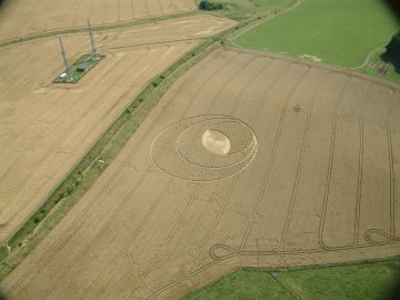
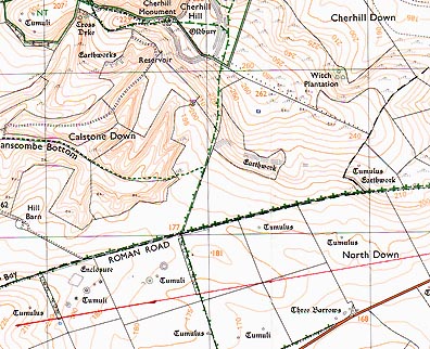
July 10, 2003 – Beckhampton, England – Farmer David Sheppard was dismayed when he found more than the usual ancient line up of burial mounds in his North Down spring barley field on July 6, 2003. Right at the end of four tumuli that have been lined up pointing towards Silbury Hill near Avebury for more than 4,000 years, was another bigger circle made from his own crop. Stuart Dike and Mark Fussell of the Cropcircleconnector.com, with the farmer’s permission, were able to get in on the ground and photograph the remarkable detail of hundreds of small, swirled clumps of standing plants that dot eleven concentric rings that radiate from a downed center.Click for report.
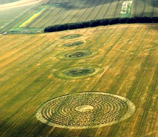
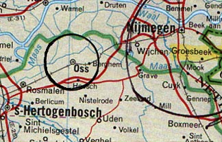
July 11, 2003 Oss, Noord Brabant, Holland and see Update below – Today Robert Boerman of the Dutch Crop Circle Archive e-mailed me about the fifth reported Dutch formation of 2003 in Oss that he investigated yesterday west of Groesbeek. The circle nearest the camera measured about 15 meters.10, or fifty feet in diameter; the largest middle circle measured about 25 meters.70, or eighty-five feet; and the furthest smaller circle measured about 9 meters.90, or about thirty-three feet in diameter.Click for report.
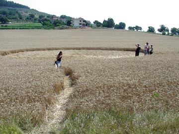
July 11, 2003 – Fornacette near Pisa (central west Italy) – Italy’s sixteenth crop formation of 2003 – an unprecedented number – was reported on June 26 in Fornacette near Pisa in central western Italy. It is a dumbbell pattern set down in the middle of a thick wheat field that had no tramlines, as English fields do. The pattern was one large circle and one smaller circle connected by a corridor. This is a pattern that was common in England in the early 1990s and has also been seen several times in Canada and other European countries. Click for report.