Part 2: Disc Light Searches and Bleaches Sand

“The disc's bright light searched the desert soil that got so hot it actually bleached the soil white.”

- J. S., Mining Engineer and Pilot


Return to Part 1.


Los Cerrillos, New Mexico (Google marker) is 25 miles southwest of Santa Fe.
Out Camino Querencia Road southeast of Los Cerrillos is where the two mining engineers were working at 11:45 PM Mountain time the second or third week of July 1977, when the 50 to 60-foot-diameter disc landed on its three, thin tripod legs.

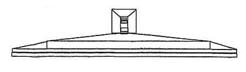
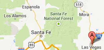
October 25, 2013 Los Cerrillos, New Mexico - Part 2 of mining engineer and pilot J. S.'s description of the close disc encounter he and his mining colleague had in the second or third week of July 1977 on Camino Querencia Road southeast of Los Cerrillos, New Mexico, about 25 miles southwest of Santa Fe.


Click here to subscribe and get instant access to read this report.

Click here to check your existing subscription status.

Existing members, login below:

102213 UPDATE – Mystery of Big New Mexico Elk Die-off – Toxic Green Algae?

– “I've never seen anything like this. And I've talked with other wildlife biologists who've seen large die-offs, and I've not run across anyone who has seen anything of this magnitude.”

– “It is probably really doubtful that hemorrhagic disease would be the cause because hemorrhagic disease is an infectious disease and would run a course through time before that many animals died and they wouldn’t die  in such close proximity to each other”

- Kerry Mower, Wildlife Health Specialist, NM Dept. of Game and Fish


Twenty miles north of Las Vegas, New Mexico (Google pointer),  113 to 120 elk were all found dead in less than one square mile on a  private ranch, August 27, 2013. NM Dept. of Game and Fish investigated.
Twenty miles north of Las Vegas, New Mexico (Google pointer), 113 to 120 elk were all found dead in less than one square mile on a private ranch, August 27, 2013. NM Dept. of Game and Fish investigated.


Click here to subscribe and get instant access to read this report.

Click here to check your existing subscription status.

Existing members, login below:

More Mysterious Boom Reports

Around 2:30 Thursday, September 12th, there was a large sound, a very loud sound, outside the west building courthouse,” but no incendiary device found.

- Lt. Carla Lightsey, Baltimore City Sheriff’s Office

“At precisely 8 PM, September 11, 2013 ... there were two booms ... houses shook and people came out of their homes looking around to see what the explosion was.”

- Earwitness resident of South Bend, Indiana


September 13, 2013 Albuquerque, New Mexico - This is a follow up to the September 8, 2013, Earthfiles update about mysterious booms in several parts of the United States. Today on Friday, September 13, 2013, Earthfiles received these additional, mysterious boom reports.


Click here to subscribe and get instant access to read this report.

Click here to check your existing subscription status.

Existing members, login below:

Mysterious New Boom Reports

“The whole beach house shook.”

- Witness, Virginia Beach, Virginia

“This is weird. Where are the booms coming from? Sometimes it's like a train backing into another train.”

- Thomas Daniel, resident in Carytown section of Richmond, Virginia


August 24, 2013, The Virginian-Pilot, Virginia Beach, Virginia.

No one can say for sure if what Nencetti and people along the Virginia Beach coast felt this morning really was a sonic boom. Residents around Hampton Roads and in northeastern North Carolina took to social media sites to report that they heard three or four loud booms.

The U.S. Geological Survey didn’t register anything this morning, but did receive reports from residents who heard the noise which some said was accompanied by shaking and came on the two-year anniversary of the 5.8 magnitude earthquake that was centered near Mineral.


September 8, 2013 Albuquerque, New Mexico - Since January 2011 when I received the first reports of bright flashes of light and loud, unexplained booms that rattle windows, garage doors and have even cracked sidewalks, I have produced more than fifty Earthfiles reports about the persistent high strangeness to date. See More Information below. The booms have come periodically and recently, I have received dozens of boom or metal crashing reports again of which a few are shared here in the hopes of learning more from other Earthfiles viewers and radio listeners. Ear and eyewitnesses, please email:  [email protected]. All requests for anonymity are honored.


Click here to subscribe and get instant access to read this report.

Click here to check your existing subscription status.

Existing members, login below:

Update September 4, 2013: Japanese Government Will Spend $470 Million On Underground Ice Wall by March 2015, to Stop Radioactive Leaks. TEPCO’s Leaking Storage Tanks Still Out of Control.

See mp3 audio interview below.

The Japanese government in Tokyo announced on Tuesday, September 3, 2013, that it will spend $470 million on an underground "ice wall" to try to stop the chronically leaking, highly radioactive waste water in its thousand containment tanks shown at the center of the Google image at left. The four damaged nuclear reactors are at the top of the aerial image and the proposed ice wall is the orange rectangle around the reactors close to the Pacific Ocean. Illustration by TEPCO.

The ice wall containment method has never been used on such a scale before. The ice wall would freeze the ground to a depth of some 90 feet (27 meters) through a system of pipes designed to carry a coolant between minus 20 to 40 degrees Fahrenheit. The U. S. Department of Energy's former site at the Oak Ridge National Laboratory in Tennessee used an ice wall to contain plutonium waste, but only for six years. Building a nearly mile long ice wall around four nuclear reactor buildings is unprecedented.


Click here to subscribe and get instant access to read this report.

Click here to check your existing subscription status.

Existing members, login below:

Part 4: U. S. Navy Captain Comments On Google Earth Image of Mutilated Cattle in Haigler, Nebraska

“Something very unusual struck me. If these two lighter and brighter colored photo strips were left over from earlier satellite photos, their location would most likely be random and not related to each other. However, if you look at the jpeg of the area I have attached to this email, they are very definitely related to the dead cows!”

- Retired Naval Flight Officer Captain Mark Wood

Haigler, Dundy County Nebraska, (Google marker) is only 100 miles southeast of Sterling, Logan County, Colorado, where hundreds of mutilated cattle, horses and other animals were reported to the Logan County Sheriff's Office from the early 1970s ongoing to date. See Earthfiles Shop for An Alien Harvest: Further Evidence Linking Animal Mutilations and Human Abductions to Alien Life Forms and the 2-volume Glimpses of Other Realities © by Linda Moulton Howe.
Haigler, Dundy County Nebraska, (Google marker) is only 100 miles southeast of Sterling, Logan County, Colorado, where hundreds of mutilated cattle, horses and other animals were reported to the Logan County Sheriff's Office from the early 1970s ongoing to date. See Earthfiles Shop for An Alien Harvest: Further Evidence Linking Animal Mutilations and Human Abductions to Alien Life Forms and the 2-volume Glimpses of Other Realities © by Linda Moulton Howe.

Return to Part 1.

Updated August 12, 2013  Albuquerque, New Mexico - I emailed to retired Naval Flight Officer Mark Wood the Google Earth image and Lat/Long coordinates of the 3 dead pregnant cows sent to me by Haigler, Nebraska rancher Alex Peterson, Updated Part 3 of these Earthfiles reports. I received back the following email from Captain Wood with written permission to use on the record his full name and military background.


Click here to subscribe and get instant access to read this report.

Click here to check your existing subscription status.

Existing members, login below:

More Unexplained Booms – Earthfiles Viewer Letters

“The boom sound built up to percussion I could feel in my lungs, and when it went past me, the air seemed to suck right out of me.  The whole experience took less than 1.5 seconds, but left me in shock.”

- Loading Dock Worker, St. George, Utah


August 5, 2013  Albuquerque, New Mexico - Since my Earthfiles and COAST reports the end of May about the unexplained boom mystery throughout the United States since 2011 - possibly linked to Earth core changes - I continue to receive many unexplained boom reports. I am sharing some in this report with the hope that scientists, who might have more information about the possible link between the persistent, strange booms and Earth core changes, will contact me. All requests for anonymity are honored.


Click here to subscribe and get instant access to read this report.

Click here to check your existing subscription status.

Existing members, login below:

Part 1:  The Ridgeway Overton 9 Rings – Diatonic Scale and Einsteinian Physics

“There are nine rings, but eight spaces between them.  The eight spaces are the diatonic musical scale - the white notes  on the piano:  do re me fa so la ti do.”

- James Lyons, Retired U. K. Aerospace Engineer about Ridgeway pattern


July 26, 2013  Petersfield, Hampshire; and Cottingham, East Yorkshire, England - For at least 5,000 years, travelers in southern England have moved more easily from the Dorset coast to Norfolk by going along the high, drier ground called The Ridgeway, now designated as an 87-mile-long National Trail in the U. K.

The Ridgeway includes Overton Hill near Avebury where on July 6, 2013, nine rings were discovered in a wheat field there. The whole pattern was large, 186 feet in diameter measured by Charles Mallett, Director of the Silent Circle research center.


Click here to subscribe and get instant access to read this report.

Click here to check your existing subscription status.

Existing members, login below:

EARTHFILES