Part 1:  Silbury Hill “Quetzlcoatl Headdress” and Mysterious Tall Blonds

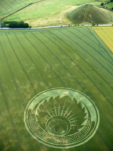
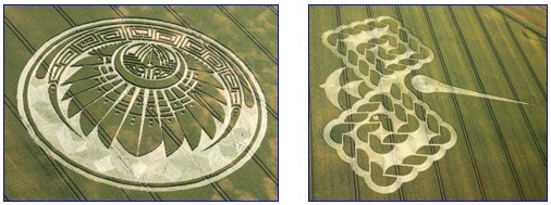
“The film crew said there was heavy dew on the laid down crop, yet there were no footprints and it was not disturbed. They said the headdress formation was immaculate.”

- Charles Mallett, Silent Circle Research Centre

 Silbury Hill “Quetzalcoatl Headdress” about 350 feet in diameter first discovered around 4:30 AM by documentary film crew that had been camped all night atop Silbury Hill and were first into the extraordinary pattern. Aerial image © 2009 by Jack Roderick. For other images and information: Cropcircleconnector.
Silbury Hill “Quetzalcoatl Headdress” about 350 feet in diameter first discovered around 4:30 AM by documentary film crew that had been camped all night atop Silbury Hill and were first into the extraordinary pattern. Aerial image © 2009 by Jack Roderick. For other images and information: Cropcircleconnector.

July 15, 2009  Silbury Hill, Wiltshire County, England - On the night of July 4 to 5, 2009, a crew of documentary filmmakers with high definition video cameras were camped on top of Silbury Hill from about 2 AM until sunup between 4 and 4:30 AM in the British higher latitude summer light. Atop Silbury Hill, the film crew was only a quarter-mile from the location of what many experienced crop formation investigators say is as spectacular a wheat formation as there has ever been. The pattern spans 350 feet in diameter with unusual shading and "immaculate" ground lay.


Click here to subscribe and get instant access to read this report.

Click here to check your existing subscription status.

Existing members, login below:

2-Stage Cannings Cross Wheat Formation Scene of Farm Arrest

Cannings Cross, Wiltshire, crop formation has evolved through farmer damage from June 27, 2009, to mysterious July 10, 2009, second stage reconstruction to July 13, 2009, arrest of farm employee with shot gun.

Part 1 of Cannings Cross near Allington, Wiltshire, England, showing June 27, 2009, first reported pattern after the angry farmer drove his tractor around in circles cutting off the points of the interior pattern.  Aerial image © 2009 by Eva-Marie Brekkestø.
Photoshop reconstruction of formation to illustrate pattern before the farmer drove around in circles cutting off the inner points. Electronic reconstruction © 2009 by Psycho Clown.
Part 2 of Cannings Cross near Allington, Wiltshire, England, reported on July 10, 2009, with additional circles at the outer points. Inside the farmer's original June 27th circles of wheat cut down, the cut off interior points have been reconstructed into fresh, new points. Aerial image © 2009 by Olivier Morel (WCCSG). For other images and information: Cropcircleconnector.

July 4, 2009  Cannings Cross near Allington, Wiltshire County, England - The Cannings Cross wheat pattern near Allington, Wiltshire, England, has been evolving through great confusion. The farm owner originally took his tractor into the first part of the formation reported on June 27, 2009, and drove in big circles to cut down the interior points of the pattern. Eva-Marie Brekkestø flew over the pattern after the farmer's destruction and took the first aerial photograph. A computer graphics artist north of Wiltshire known as Psycho Clown then volunteered to reconstruct what the formation looked like before the farmer's tractor destruction and produced a Photoshop reconstruction.


Click here to subscribe and get instant access to read this report.

Click here to check your existing subscription status.

Existing members, login below:

UK “Quetzalcoatl Headdress” and “Sixth Sun Tzolkin”?

Left: Silbury Hill near Avebury, Wiltshire, England, reported July 5, 2009. Right: West Down Gallops near Beckhampton, Wiltshire, England, not far from Silbury Hill and Avebury, reported July 4, 2009. Both aerial images © 2009 by Lucy Pringle. For other images and information: Cropcircleconnector.


Return to Mark PDF 1

Return to Mark PDF 2

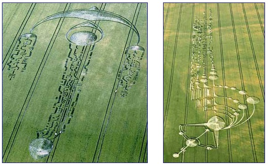
July 6, 2009  Wiltshire County, England - Mark in Colorado, who worked in computer signal processing for thirteen years, has sent two more PDFs concerning the July 4, 2009, crop formation at the West Down Gallops near Beckhampton, Wiltshire, England, followed the next day by what Mark calls the “Quetzalcoatl headdress” reported July 5, 2009, at Silbury Hill near Avebury, not far from the Beckhampton pattern.


Click here to subscribe and get instant access to read this report.

Click here to check your existing subscription status.

Existing members, login below:

UK “Nazca Hummingbird” – Astronomical and Mayan Counting

Top:  “Nazca Bird” reported July 2, 2009, below Milk Hill near Stanton St. Bernard, Wiltshire, England. Aerial image © 2009 by D. Grove. Bottom:  Hummingbird on Plains of Nazca (500 B. C. to 500 A. D.), 250 miles south of Lima, Peru. Aerial image © Go2Peru.com. Images and information by: Cropcircleconnector.

July 3, 2009  Wiltshire County, England - This morning I received the following UK crop formations from 2008 and 2009, that the Australian scientist proposes have each related to astronomical countdowns to predicted solar events. The current question today is: since April 14, 2009, and the first UK crop formation at The Ridgeway in flowering oilseed rape, has the crop formation intelligence been forecasting a major solar eruption for Tuesday, July 7, 2009, perhaps occurring in the late afternoon in English time?  [ See:  Earthfiles043009 ]


Click here to subscribe and get instant access to read this report.

Click here to check your existing subscription status.

Existing members, login below:

Part 3: “Alien Symbols” in Milk Hill and South Field

Left:  “Alien symbols” or “electrical grids” in South Field wheat near Alton Priors, Wiltshire, England, reported June 27, 2009. Aerial image © 2009 by Julian Gibsone. Right:  Milk Hill Summer Solstice crop formation that evolved in three parts: Part 1 reported on June 21; Part 2 reported on June 22; and Part 3 reported on June 30, was an addition of five, 700-foot-long lines of  “alien symbols.” Aerial image © 2009 by Lucy Pringle.  Images and information by:   Cropcircleconnector.
Return to Part 1

July 3, 2009  Wiltshire County, England - The following PDF was emailed to me on July 1, from a man named Mark in Colorado, who worked in computer signal processing for thirteen years. Mark has studied crop formation patterns with curiosity since 1993. About the 2009 patterns, he says, “I'm starting to see how they fit together over time and space in the past and present. So, in the future I think we'll all see more and more links between the patterns and maybe we'll begin to have more understanding about what is being communicated. And I think the crop circle intelligence will be reacting to our own human consciousnesses as we try to see past and present links in the crop formations.”


Click here to subscribe and get instant access to read this report.

Click here to check your existing subscription status.

Existing members, login below:

Part 1: “Alien Symbols” in Milk Hill and South Field

Left:  “Alien symbols” or “electrical grids” in South Field wheat near Alton Priors, Wiltshire, England, reported June 27, 2009. Aerial image © 2009 by Julian Gibsone. Right:  Milk Hill Summer Solstice crop formation that evolved in three parts: Part 1 reported on June 21; Part 2 reported on June 22; and Part 3 reported on June 30, was an addition of five, 700-foot-long lines of  “alien symbols.” Aerial image © 2009 by Lucy Pringle.  Images and information by:   Cropcircleconnector.

July 2, 2009  Wiltshire County, England - Below Milk Hill's White Horse at 4:30 AM on Summer Solstice Sunday, June 21, 2009, Steve Amor reported to Cropcircleconnector.com that there was a “circle and pattern” in the wheat field there.


Click here to subscribe and get instant access to read this report.

Click here to check your existing subscription status.

Existing members, login below:

Part 2: “Alien Symbols” in Milk Hill and South Field

Left:  “Alien symbols” or “electrical grids” in South Field wheat near Alton Priors, Wiltshire, England, reported June 27, 2009. Aerial image © 2009 by Julian Gibsone. Right:  Milk Hill Summer Solstice crop formation that evolved in three parts: Part 1 reported on June 21; Part 2 reported on June 22; and Part 3 reported on June 30, was an addition of five, 700-foot-long lines of  “alien symbols.” Aerial image © 2009 by Lucy Pringle.  Images and information by:   Cropcircleconnector.

Return to Part 1

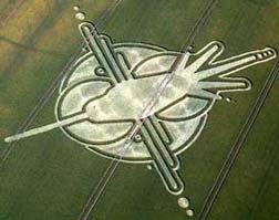
July 2, 2009  Wiltshire County, England - The Australian scientist and retired physicist and telescope engineer, Mike Reed, have been analyzing the June 27, 2009, South Field pattern of “alien symbols” and comparing them to the Milk Hill symbols that emerged on June 30, 2009, as a third addition to the original Summer Solstice versions of June 21 to June 22, 2009, discussed in Part I of this Earthfiles report.


Click here to subscribe and get instant access to read this report.

Click here to check your existing subscription status.

Existing members, login below:

Mysterious Northeast Bat Deaths Now in 9 States and Headed Toward Kentucky

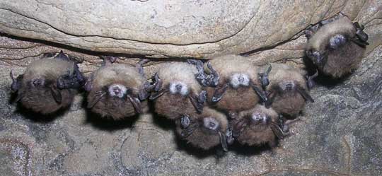
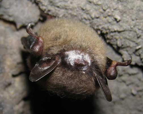
“This bat die-off is unprecedented and this precipitous decline we have seen is probably the greatest loss of wildlife in North America in at least a century.”

- Thomas Kunz, Ph.D., Boston University


Click for podcast.
Click for podcast.
Eight Little Brown Bats hanging upside down in hibernation west of Albany, New York, inside Hailes Cave in February 2007. Unidentified white fungus rings the noses on seven. Bat mortality in two caves affected by the white-nose syndrome was 90% and 97%. By February 2008, the white-nose syndrome has spread to twenty caves in New York state, southwestern Vermont and western Massachusetts. By spring 2009, at least a million bats have died in nine states and Kentucky could be next. Image © 2007 by Nancy Heaslip.
 Little Brown Bat (Myotis lucifugus) hibernating in West Virginia cave has white ring of the never-before-seen fungal genus, now named Geomyces destructans, around its nose and on its ears. Image © 2009 by Craig W. Stihler, Ph.D., West Virginia Dept. of Natural Resources.
Little Brown Bat (Myotis lucifugus) hibernating in West Virginia cave has white ring of the never-before-seen fungal genus, now named Geomyces destructans, around its nose and on its ears. Image © 2009 by Craig W. Stihler, Ph.D., West Virginia Dept. of Natural Resources.

June 26, 2009  Boston, Massachusetts - Bats are dying in the Northeastern United States at a rate never seen before by scientists and the leading culprit is a fungus that was finally named this month for what it does: Geomyces destructans. It’s a brand new fungus never seen before. Bats are mammals and mammals have never been destroyed by a fungus like this before either.


Click here to subscribe and get instant access to read this report.

Click here to check your existing subscription status.

Existing members, login below:

Updated – Is A/H1N1 Outbreak A “Herald Wave” Preceding More Serious Fall 2009 Epidemic? 

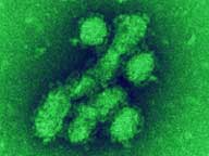
“I do not think we are off the hook in the United States. I don’t think we should be complacent to think we’re not going to have it as bad as Mexico because I think if conditions were different and we were now in the Fall of 2009 and it was getting colder, we might see much more disease here.”

- Paul Glezen, M. D., Molecular Virologist

A/H1N1 flu virus is seen in an image taken using an electron microscope, at National Microbiology Laboratory, Public Health Agency of Canada.
Click for podcast.
Click for podcast.

Updated May 28, 2009/ Original report May 7, 2009  Houston, Texas - The Centers for Disease Control and Prevention (CDC) has had a series of phone press conferences to discuss the latest swine flu developments. Today, CDC’s Interim Deputy Director for Science and Public Health Program, Anne Schuchat, M. D., (SHOE-cut) confirmed that 8,585 cases of swine flu have been officially reported to American medical authorities, with 507 hospitalizations and the twelfth death of a Chicago resident last weekend. Authorities estimate that only one in twenty swine flu victims are being reported, so there could be at least 150,000 Americans now sick with this new swine flu.


Click here to subscribe and get instant access to read this report.

Click here to check your existing subscription status.

Existing members, login below:

EARTHFILES