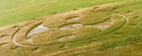
October 2, 2012 Tlapanaloya, Tequixquiac, Mexico - Last week Jaime Maussan, a well known Mexico City TV reporter and producer of Tercer Melnio, called me about the report of a crop formation at least 180 feet in diameter in oats north of Mexico City. He emailed me a ground photograph taken by an investigator for Tercer Milenio, who arrived several hours after the pattern was first found on Sunday morning, September 23, 2012. There is an outer circle of sixteen small triangles around the perimeter narrow ring that point towards the central pattern that can be seen more clearly in the aerials below.
Click here to subscribe and get instant access to read this report.
Click here to check your existing subscription status.
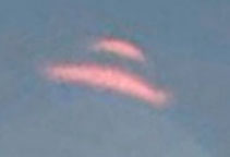
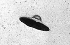
“Both UFO images are definitely lens flares. Their tops point
directly at the sun, and both have those flarey, balloon-like
diffraction patterns under them.”
- Daniel, Professional Photographer
Top: Unidentified aerial object in Acoma Pueblo, New Mexico, 2012 Google Map Street View. Bottom: Photo, July 31, 1952, Passoria, New Jersey. Photo source: UFOEvidence.org.
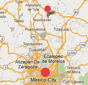
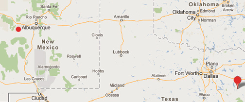
Jacksonville, Texas, is a town of about 15,000 people southeast of Dallas in Cherokee County (lower right red circle). Acoma Pueblo in New Mexico is about 60 miles west of Albuquerque near the El Malpais National Monument (upper left smaller red circle) with a population of about 5,000 Native Americans, who have continuously occupied the pueblo for more than 800 years. The distance between the two sites is 845 miles.
Updated: October 2, 2012 Albuquerque, New Mexico - Recently on September 28, 2012, ABC's Good Morning America reported: “UFO or Lens Flare in Google Street View? You Decide” This was the network follow up to its ABC affiliate KLTV 7's September 26, 2012, East Texas report, “Caught on Tape: UFO On Google Maps? Strange Sight Caught in Sky.”
Click here to subscribe and get instant access to read this report.
Click here to check your existing subscription status.
“There is something coming and the fabric of space and time
is getting thin and things are coming through. ... I think it’s going
to be either time travelers or other-dimensional beings.”
- Shane Elam, Commercial Real Estate, Oklahoma City, Oklahoma
September 28, 2012 Oklahoma City, Oklahoma - Shane Elam's last name comes from the ancient Elamites, a bloodline in Shane's family. Elam was to the east of Sumer, in the Zagros Mountains of what we call today Iran. Susa was its capital. The Elamites were one of the first cultures to adapt the Sumerian writing system to fit their own language. The earliest Elamite kings date back to almost 5,000 years ago. Elam was often at war with Mesopotamia's city of Ur.
Click here to subscribe and get instant access to read this report.
Click here to check your existing subscription status.
“The group that we think contributed this foreign DNA to these
African populations was much more closely related to anatomically
modern humans than Homo erectus. I think it is more appropriate to think
of this foreign group as about as different as Neanderthals were
to Cro-magnon Homo sapiens sapiens.”
- Joshua Akey, Ph.D., Assoc. Prof. of Genome Sciences, Univ. of Washington, Seattle
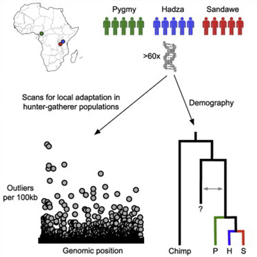
To reconstruct modern human evolutionary history, Prof. Akey and his Genome Sciences team at the University of Washington in Seattle, sequenced the whole genomes of five individuals in each of three different hunter-gatherer populations: Pygmies from Cameroon; the Khoesan-speaking Hadza and Sandawe from Tanzania. Graphic by Joshua Akey, Ph.D.Until the late 1900s, many researchers believed that humans evolved from an apelike ancestor through a linear series of stages, but instead of smoothly evolving evolution, the truth is closer to many “branches of twigs” from a large, family tree that has unexpected and unidentified “foreign DNA” from the distant past. Graphic source DNA Learning Center.
September 27, 2012 Seattle, Washington - The August 3, 2012, issue of the journal Cell featured a new DNA study of three African populations that provoked the Seattle Times to headline: “Sex with Early Mystery Species of Humans Seen in DNA.” The subject is foreign DNA that does not resemble DNA from any modern humans and not even from Neanderthal DNA. Was it ancient sex? Or genetic manipulation of already-evolving primates by non-human intelligences terraforming Earth as described in leaked, alleged government documents shown to me and others since at least the early 1980s? See Earthfiles Archive.
Click here to subscribe and get instant access to read this report.
Click here to check your existing subscription status.
“Rats exposed to even the smallest amounts of Roundup and NK603 Roundup-tolerant corn developed mammary tumors and severe liver and kidney damage.”
- Prof. Gilles-Eric Seralini, Ph.D., Universite de Caen, France
Large cancerous tumors on white mice fed NK603 Roundup-tolerant genetically modified corn or given water containing Roundup at levels permitted in drinking water. This is the first medical study to examine long-term effects of Monsanto's Roundup herbicide and NK603 Roundup-resistant GMO corn created by Monsanto. CRIIGEN research led by Prof. Gilles-Eric Seralini published September 19, 2012, in Food and Chemical Toxicology.
Food and Chemical Toxicology, September 19, 2012.
September 27, 2012 Oakland, California - According to the U. S. Department of Agriculture's Economic Research Service, in 2011 the percent of corn crops in America that contain some form of genetic engineering is 96% . Most of that genetic engineering is Monsanto's Roundup-resistant corn in which the Roundup NK603 herbicide is built into the plant.
Click here to subscribe and get instant access to read this report.
Click here to check your existing subscription status.
“Since we know that the Google Mars image is older, and of higher
resolution than the fake Photoshopped image, then perhaps as it got closer to the Curiosity Landing date, and the Mars Orbiter was used to take more photos of the Curiosity landing zone ... perhaps NASA saw something that hadn’t been in earlier photos ... and needed to be covered up.”
- Retired U. S. Navy Captain
“I find it interesting that in Google Earth->Mars, there are two high-resolution image strips of the Curiosity landing area with a big gap between them, and that whatever they're hiding falls in that gap.”
- Daniel
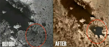
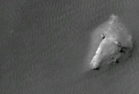
The original Martian Gale crater aerial image on the left was taken by a Mars-orbiting spacecraft and distributed by NASA/JPL. There is no "lake" with appendages. But in a later NASA/JPL image on the right, for unknown reasons, the "lake" with appendages has been pasted in to cover up what? Further, the "lake" was copied and retouched from an actual feature on a high-resolution NASA image discussed below. Source images by NASA/JPL.
Editorial Note: The word "lake" in quotation marks is used throughout this Earthfiles report to denote the darker, lake-like patterns, but does not literally mean liquid water, which cannot last long on the surface of Mars without sublimating into the atmosphere. Speculation is that the darker colored patterns that resemble lakes are mineral residues that are currently unidentified on what appear to be the bottoms of ancient lake beds.
Extreme close up on the Gale Crater "lake pattern" discussed in this report to show the ripple patterns of the presumed ancient lake bed surrounding the three "islands" in the "lake," including this largest "island" that was retouched out of the copy/paste digital manipulation of the Gale crater landscape described in this Earthfiles report. Image source NASA/JPL.
Updated September 24, 2012 Albuquerque, New Mexico - On September 21, I received an email with the following YouTube URL posted on September 19, 2012, by “SunsFlare.” I was asked to view what was described as deliberately faked Gale Crater images on Mars. Gale Crater is where the Curiosity Mars Science Lab rover landed on August 5, 2012, at 10:31 PM Pacific to explore for evidence of water and chemistry of life on the Red Planet.
Click here to subscribe and get instant access to read this report.
Click here to check your existing subscription status.
“This is as super secret a situation as the Manhattan Project was. Nobody is supposed to know this place even exists. ...This thing is some kind of power generator and it’s thousands of years old, it’s made out of stone like a pyramid. They don’t know where it came from, who made it or how it works. But it can generate enough power to power the whole North Slope, all of Alaska, and probably the whole country of Canada!”
- USAF Huey pilot to Bruce Pearson's father
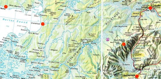
This map shows Nome far upper left; then Unalakleet on eastern edge of Norton Sound; then purple circle with white pyramid at the latitude and longitude west of Mt. McKinley (red circle) where retired Navy Captain reported finding a “square” anomaly in the landscape that could be the site of a large underground pyramid.
Updated September 16, 2012, with mp3 / Original September 10, 2012 Albuquerque, New Mexico -
Helicopter Flight from Unalakleet
to Underground Pyramid Site
Late April or Early May 1978
On September 3, 2012, I received a long email from yet another son about his father's firsthand knowledge of an underground pyramid approximately two hours east of Unalakleet by Huey helicopter in the late April or early May 1978 time frame. The son gave me permission to use his full real name, Bruce L. Pearson. Bruce, 55, is Chief Executive Officer for Broadcastvenue.com and does reporting for HD Media Production in Clinton, New Jersey.
Click here to subscribe and get instant access to read this report.
Click here to check your existing subscription status.
“The pilot told my dad the Alaska site was ‘every bit as hush hush as the Manhattan Project.’ ...The pilot also told him that it was not a nuclear device; it was not made by man; it was an incredibly old pyramid and they had no idea where it came from or how it was built underground of cut stone; and it was capable of producing enough energy to power the whole North Slope, all of Alaska and most, if not all, of Canada!”
- Bruce Pearson, New Jersey
“Bill” had been in an underground base or facility that had been built there in Alaska for the purpose of working on ‘alien’ technology and biology.”
- August 26, 2012 email to Earthfiles
This map shows Nome far upper left; then Unalakleet on eastern edge of Norton Sound; then purple circle with white pyramid at the latitude and longitude west of Mt. McKinley (red circle) where retired Navy Captain reported finding a “square” anomaly in the landscape that could be the site of a large underground pyramid.
September 6, 2012 Albuquerque, New Mexico - The alleged underground pyramid structure west of Mount McKinley continues to provoke email since my original Earthfiles and Coast to Coast radio interview with Doug Mutschler, retired U. S. Army Counterintelligence Warrant Officer, with information about an underground pyramid was posted on July 26, 2012. See: Updated Parts 1 - 3: 072712 Earthfiles.
Click here to subscribe and get instant access to read this report.
Click here to check your existing subscription status.
“...the Ballistic Missile Early Warning System (BMEWS) construction
could have been used as a cover up for the assembly of a group of highly technical people to all of a sudden leave their families and jobs in the States to fly to Alaska.”
- Retired Navy Captain
This map shows Nome far upper left; then Unalakleet on eastern edge of Norton Sound; then purple circle with white pyramid at the latitude and longitude west of Mt. McKinley (red circle) where retired Navy Captain reported finding a “square” anomaly in the landscape that could be the site of a large underground pyramid.
September 2, 2012 Albuquerque, New Mexico - The alleged underground pyramid structure west of Mount McKinley has provoked a lot of email since my original Earthfiles and Coast to Coast radio interview with Doug Mutschler, retired U. S. Army Counterintelligence Warrant Officer, with information about an underground pyramid was posted on July 26, 2012. See: Updated Parts 1 - 3: 072712 Earthfiles.
Click here to subscribe and get instant access to read this report.
Click here to check your existing subscription status.


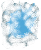 Blue-white “angelic” light “surrounded me like warm silk”
and left Oklahoma commercial real estate planner with
the thought that “something big is coming” in the
close future. Illustration © 2012 by Shane Elam.
See: 092812 Earthfiles.
Blue-white “angelic” light “surrounded me like warm silk”
and left Oklahoma commercial real estate planner with
the thought that “something big is coming” in the
close future. Illustration © 2012 by Shane Elam.
See: 092812 Earthfiles.