Strange Martian Moon Phobos – Could Its Dust Have Evidence of Life?

“One can make a pretty cogent argument that life might
have been started initially on Mars and then perhaps 4 billion years
ago came to Earth as a result of these natural impacts.”

- Jay Melosh, Ph.D.,


The dark disc is the Martian moon Phobos transiting between Mars and the Sun, as seen by Mars Rover Opportunity on March 10, 2004. Image frame from: VIDEO NASA March 10, 2004, Opportunity.
Martian moon Phobos with its Stickney Crater is considered a “captured” asteroid with low density that is in an unusual circular and low orbit around Mars. Image by NASA's Viking 1 Orbiter in 1977.

March 1, 2013  West LaFayette, Indiana - Phobos and Deimos are the two moons that orbit Mars. Phobos is notoriously strange and small - only about 17 miles long and 11 miles wide, shaped a bit like a potato. Phobos is one of the darkest bodies in our solar system with composition similar to carbonaceous chondrites, the space rocks that contain higher percentages (3% to 22%) of water as well as organic compounds. Adding to the mystery is that Phobos has an unusual circular orbit that is very close to Mars, puzzling planetary scientists about how that occurred since most solar system bodies do not have circular orbits. Phobos moves around Mars faster than Mars itself rotates. That's why Phobos rises and sets twice each Martian day. The Phobos orbit is so low that its angular diameter as seen from the surface of Mars varies visibly as its position moves in the sky. Further, Phobos's density is too low to be solid rock, sparking speculation that Phobos is not only porous, but is hollow and perhaps even an artificial construction.


Click here to subscribe and get instant access to read this report.

Click here to check your existing subscription status.

Existing members, login below:

Morphogenetic Fields, Telepathy and Science Set Free

“The morphogenetic field is a bit like a magnetic field that organizes iron filings in particular patterns - so there is a group field and every animal group has that.”

- Rupert Sheldrake, Ph.D., Biochemist and Author

Schools of fish, flocks of birds, human families move in  synchronized patterns influenced by morphogenetic fields that link and shape close groups of living organisms. Image © by Wolcott Henry.
Schools of fish, flocks of birds, human families move in synchronized patterns influenced by morphogenetic fields that link and shape close groups of living organisms.
Image © by Wolcott Henry.


January 31, 2013  London, England
- Rupert Sheldrake was born in Nottinghamshire, England, seventy years ago with a destiny to challenge established scientific paradigms. By 1974, he had received his Ph.D. in biochemistry from the University of Cambridge and spent the next ten years to 1985 working as a plant physiologist in India for the International Crops Research Institute for Semi-Arid Tropics. That’s when he wrote his first groundbreaking, but controversial book, A New Science of Life, published in 1981. See More Information below.


Click here to subscribe and get instant access to read this report.

Click here to check your existing subscription status.

Existing members, login below:

Rapid, Unidentified Aerial Objects Over Denver  and Strange Amber Cigar-Shaped Aerial Craft Near Philadelphia

“The strangest part is they are flying too fast to see with the naked eye, but when we slowed down the video, several UFOs appear.”

- Heidi Hemmat, Reporter, KDVR-FOX TV, Denver, Colorado

“I was seeing something not of this Earth - or if it is from this Earth, it shouldn’t be in the sky. It was like at a 45-degree angle. It was amber in color. It was cigar-shaped.”

- I-95 Turnpike Eyewitness near Boothwyn, PA


November  11, 2012  Denver, Colorado and Boothwyn, Pennsylvania - On November 8, 2012, Investigative Reporter Heidi Hemmat at KDVR-FOX31 TV in Denver, Colorado, reported about a “Mile High Mystery: UFO Sightings in Sky Over Denver.”  See Websites below for full video.

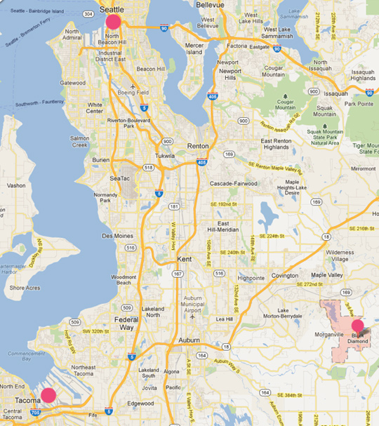
The following are some video frames of the object photographed by the anonymous eyewitness, who contacted the station. He videotapes from a hilltop in Federal Heights looking south toward downtown Denver. He says if he aims his camera toward 56th Avenue and Clay Street, the odd, rapidly moving aerial objects that he can't see with his naked eyes seem to rise up from and land near that intersection when his video is slowed down. “The flying objects appear around noon or 1:00 p.m. at least a couple of times a week.”


Click here to subscribe and get instant access to read this report.

Click here to check your existing subscription status.

Existing members, login below:

What Did Huge, Silent, Triangle Aircraft Drop into Black Diamond, WA Lake?

“The triangle craft turned over and ever so slowly, one of those orange globes underneath dropped at the lake.”

- Gregory McManus, Black Diamond, WA resident

Black Diamond, Washington, September 2, 2012, at 3:52 AM. Illustration © 2012 by resident Gregory McManus.
Black Diamond, Washington, is about 30 miles southeast of Seattle and Puget Sound.

October 26, 2012  Black Diamond, Washington -  On September 2, 2012, at 3:52 AM in Black Diamond, Washington, about 30 miles southeast of Seattle, a dog near Southeast 300th Street started barking as if “intimidated” by something. The dog's fearful bark was not normal and concerned Gregory McManus next door. Greg is a 54-year-old power line machinist, who moved with his wife to their Black Diamond home in 2003 near a canal that flows into Covington Creek that flows into Lake Sawyer to the Green River, which flows into the Puget Sound.


Click here to subscribe and get instant access to read this report.

Click here to check your existing subscription status.

Existing members, login below:

Global Warming Is Expected to Increase from Rapid Arctic Ice Melt and Methane Release.

“Climate models have predicted a retreat of the Arctic sea ice; but the actual retreat has proven to be much more rapid than the predictions.”

- Claire Parkinson, Ph.D., Climate Researcher, NASA Goddard

“The final Arctic summer sea ice collapse is now happening and will probably be complete by 2015 to 2016.”

- Peter Wadhams, Ph.D., Dir., Polar Ocean Physics Group,
Cambridge University, U. K.


An image of the Arctic sea ice on September 16, 2012, the day that the National Snow and Ice Data Center reported the minimum Arctic ice cover on record. The yellow outline shows the average sea ice minimum from 1979 through increasing summer ice melt to 2010. Illustrated image provided by NASA Goddard's Visualization Explorer.

October  25, 2012  Cambridge, England -  The U. S. National Oceanic and Atmospheric Administration reports that the first nine months of 2012 were the warmest on record for the contiguous United States. Further, the Arctic is melting faster than any computer model ever predicted. For the first time on record, 75% of the Arctic sea ice had melted by mid-September 2012. The National Snow and Ice Data Center at the University of Colorado says that direct satellite measurements of the Arctic sea ice began in the late 1970s, but it has been at least a few thousand years since the Arctic has had so much open water.


Click here to subscribe and get instant access to read this report.

Click here to check your existing subscription status.

Existing members, login below:

Ancient Foreign DNA Found in Modern Human DNA

“The group that we think contributed this foreign DNA to these
African populations was much more closely related to anatomically
modern humans than Homo erectus. I think it is more appropriate to think
of this foreign group as about as different as Neanderthals were
to Cro-magnon Homo sapiens sapiens.”

- Joshua Akey, Ph.D., Assoc. Prof. of Genome Sciences, Univ. of Washington, Seattle


To reconstruct modern human evolutionary history, Prof. Akey and his Genome Sciences team at the University of Washington in Seattle, sequenced the whole genomes of five individuals in each of three different hunter-gatherer populations: Pygmies from Cameroon; the Khoesan-speaking Hadza and  Sandawe from Tanzania. Graphic by Joshua Akey, Ph.D.
To reconstruct modern human evolutionary history, Prof. Akey and his Genome Sciences team at the University of Washington in Seattle, sequenced the whole genomes of five individuals in each of three different hunter-gatherer populations: Pygmies from Cameroon; the Khoesan-speaking Hadza and Sandawe from Tanzania. Graphic by Joshua Akey, Ph.D.
Until the late 1900s, many researchers believed that humans evolved from an apelike  ancestor through a linear series of stages, but instead of smoothly evolving evolution,  the truth is closer to many “branches of twigs” from a large, family tree that has unexpected and unidentified “foreign DNA” from the distant past. Graphic source DNA Learning Center.
Until the late 1900s, many researchers believed that humans evolved from an apelike ancestor through a linear series of stages, but instead of smoothly evolving evolution, the truth is closer to many “branches of twigs” from a large, family tree that has unexpected and unidentified “foreign DNA” from the distant past. Graphic source DNA Learning Center.

September 27, 2012  Seattle, Washington - The August 3, 2012, issue of the journal Cell featured a new DNA study of three African populations that provoked the Seattle Times to headline:  “Sex with Early Mystery Species of Humans Seen in DNA.”  The subject is foreign DNA that does not resemble DNA from any modern humans and not even from Neanderthal DNA. Was it ancient sex? Or genetic manipulation of already-evolving primates by non-human intelligences terraforming Earth as described in leaked, alleged government documents shown to me and others since at least the early 1980s? See Earthfiles Archive.


Click here to subscribe and get instant access to read this report.

Click here to check your existing subscription status.

Existing members, login below:

Updated: Why Is NASA Faking Gale Crater Images On Mars?

“Since we know that the Google Mars image is older, and of higher
resolution than the fake Photoshopped image, then perhaps as it got closer to the Curiosity Landing date, and the Mars Orbiter was used to take more photos of the Curiosity landing zone ... perhaps NASA saw something that hadn’t been in earlier photos ... and needed to be covered up.”

 - Retired U. S. Navy Captain

“I find it interesting that in Google Earth->Mars, there are two high-resolution image strips of the Curiosity landing area with a big gap between them, and that whatever they're hiding falls in that gap.”

- Daniel


The original Martian Gale crater aerial image on the left was taken by a Mars-orbiting spacecraft and distributed by NASA/JPL. There is no "lake"  with appendages. But in a later NASA/JPL image on the right, for unknown reasons,  the "lake" with appendages has been pasted in to cover up what?  Further, the "lake" was copied and retouched from an actual feature on a high-resolution NASA image discussed below. Source images by NASA/JPL.
The original Martian Gale crater aerial image on the left was taken by a Mars-orbiting spacecraft and distributed by NASA/JPL. There is no "lake" with appendages. But in a later NASA/JPL image on the right, for unknown reasons, the "lake" with appendages has been pasted in to cover up what?  Further, the "lake" was copied and retouched from an actual feature on a high-resolution NASA image discussed below. Source images by NASA/JPL.

Editorial Note: The word "lake" in quotation marks is used throughout this Earthfiles report to denote the darker, lake-like patterns, but does not literally mean liquid water, which cannot last long on the surface of Mars without sublimating into the atmosphere. Speculation is that the darker colored patterns that resemble lakes are mineral residues that are currently unidentified on what appear to be the bottoms of ancient lake beds.

 Extreme close up on the Gale Crater "lake pattern" discussed in this report to show the ripple patterns of the presumed ancient lake bed surrounding the three "islands"  in the "lake," including this largest "island" that was retouched out of the copy/paste digital manipulation of the Gale crater landscape described  in this Earthfiles report. Image source NASA/JPL.
Extreme close up on the Gale Crater "lake pattern" discussed in this report to show the ripple patterns of the presumed ancient lake bed surrounding the three "islands" in the "lake," including this largest "island" that was retouched out of the copy/paste digital manipulation of the Gale crater landscape described in this Earthfiles report. Image source NASA/JPL.

Updated September 24, 2012  Albuquerque, New Mexico - On September 21, I received an email with the following YouTube URL posted on September 19, 2012, by “SunsFlare.” I was asked to view what was described as deliberately faked Gale Crater images on Mars. Gale Crater is where the Curiosity Mars Science Lab rover landed on August 5, 2012, at 10:31 PM Pacific to explore for evidence of water and chemistry of life on the Red Planet.


Click here to subscribe and get instant access to read this report.

Click here to check your existing subscription status.

Existing members, login below:

Arctic Ice Melt Shrinks At Record Pace, While Greenland Also Melts.

“I don’t think it is the 0.1 centigrade (0.18 degrees F.) warming around northern Greenland which is five times the global warming average that the Defense Department worries about as much as coming wars over water, food, fossil fuels and other Earth resources.”

- Andreas Muenchow, Ph.D., Assoc. Prof. Earth, Ocean and Environment, Univ. of Delaware

August 17, 2012  Newark, Delaware - The U. S. National Snow & Ice Data Center in Boulder, Colorado, reports, “The average pace of Arctic ice loss since late June 2012 has been rapid at just over 38,000 square miles per day (100,000 sq. km).  However, this pace nearly doubled for a few days in early August during a major Arctic cyclonic storm.”


Click here to subscribe and get instant access to read this report.

Click here to check your existing subscription status.

Existing members, login below:

Updated: Was Biggest Canyon in the Solar System Scarred by Plasma? Was Biggest Canyon in the Solar System Scarred by Plasma? 

“Valles Marineris looks like nothing more than an electric arc
blasting across the surface of Mars and removing immense
amounts of material from the planet.”

- David Talbott, Video Producer, The Lightning-Scarred Planet Mars

Valles Marineris, our solar system's biggest canyon, runs along the Martian equator for 2,500 miles (4000 km) at depths up to 4 miles (7 km ). For comparison, Arizona's Grand Canyon is about 500 miles long (800 km) and 1 mile deep (1.6 km). Valles Marineris spans one-fifth of the entire distance around Mars! NASA 1980 global mosaic image by Viking 1.

Updated with mp.3 audio. July 29, 2012  Albuquerque, New Mexico - The 19th Annual National Philosophy Alliance (NPA) conference was held July 25 - 28, 2012, at the Marriott Pyramid North hotel in Albuquerque, New Mexico. Presentations ranged from quantum physics and relativity to the electric universe hypothesis. Electric universe researcher David Talbott argues that Valles Marineris on Mars was sculpted by large bolts of plasma, not by water or continental drift forces seen on Earth. Further, Wallace Thornhill from Chapman in the Australian Capital Territory near Canberra, presents new evidence that hourglass-shaped and filamentous galactic nebulae are linked to electrical behavior more than gravity.


Click here to subscribe and get instant access to read this report.

Click here to check your existing subscription status.

Existing members, login below:

Updated Part 1: Is There A Large Pyramid Underground Between Mt. McKinley and Nome, Alaska?

Updated with mp3 audio of interview.

“My father was 're-recruited' by the military to join a group of other experts to study and work at an underground structure in Alaska that in his words they called the‘Dark Pyramid.’”

- July 27, 2012 email to Earthfiles

“What the geologists said they found in this byline news story (Anchorage TV Channel 13) story was under Alaska, they found a pyramid bigger than the one in Egypt.”

- Douglas A. Mutschler, Chief Warrant Officer, U. S. Army Counterintelligence

Mount McKinley is north of Anchorage. Nome is upper left red circle on Norton Sound west of Mount McKinley. The region between Mount McKinley and Nome is where the large pyramid structure was allegedly found during geophysical studies of the May 22, 1992, Chinese underground detonation of a large nuclear bomb at Lop Nor.

Updated August 10, 2012 / Original Report July 27, 2012 - I continue to receive email from a wide variety of professionals with comments about the possible underground pyramid structure in Alaska between Mount McKinley and Nome said to be larger that the Great Pyramid of Giza in Egypt. One particularly noteworthy email is dated July 27, 2012.


Click here to subscribe and get instant access to read this report.

Click here to check your existing subscription status.

Existing members, login below:

Earthfiles