Return to Part 1: Yatesbury Spiral - Viewer Comments on Spiral Math
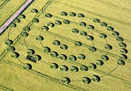
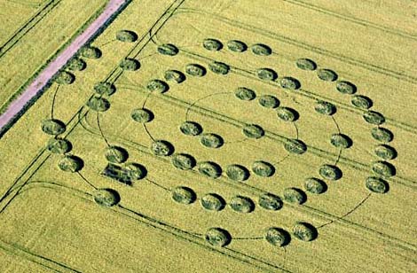
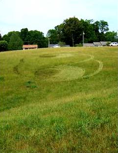
June 6, 2007 Yatesbury Field, Wiltshire, England - Two crop formations an ocean apart - one in English barley near the ancient and sacred ground of Avebury Trusloe on Yatesbury Field; the other in a Madisonville, Tennessee, wheat field not far from the historic Cherokee Indian capital of Chota and even more ancient 9,500-year-old Icehouse Bottom. (See Part 3: Madisonville Circles.) The English pattern has fifty-seven circles threaded on a thin, 4-inch-diameter spiral. The Tennessee pattern has nine circles with a triangular "pointer" in the middle standing circle that aims west in the opposite direction from Chota.
Click here to subscribe and get instant access to read this report.
Click here to check your existing subscription status.
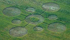
June 4, 2007 Albuquerque, New Mexico - So many Earthfiles readers today were provoked by the Yatesbury Field spiral "abacus" and the single circle in the other field that seems to reinforce the importance of the number "1" in the spiral counting. Among the many emails was communication from Chris Steele of ICCRA (Independent Crop Circle Research Association).
Click here to subscribe and get instant access to read this report.
Click here to check your existing subscription status.
“It’s not really so much of a question whether the dangerous tipping point occurs at 450 or 550 ppmv CO2. It’s how do we get the (greenhouse) emissions under control so we don’t push past all the possible points at which the climate change becomes a seriously dangerous issue.”
- Chris Field, Ph.D., Director, Carnegie Institution's Dept. of Global Ecology, Stanford University, Palo Alto, Calif.
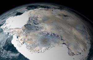
Almost 98% of the Antarctica South Pole continent is covered by ice, which averages a mile thick. Antarctica lost much more ice to the sea than it gained from snowfall, according to a NASA survey done between 1992 and 2002. It also had a corresponding rise in sea level. The survey documented for the first time extensive thinning of the West Antarctic ice shelves. Credit: NASA/SVSSatellite image courtesy NASA.
June 1, 2007 New York, New York - The United Nations Intergovernmental Panel on Climate Change reported this year that there is at least a 90% certainty that global warming is man-made and will “continue for centuries.” The IPCC also reports that in coming decades, rising temperatures and rising sea levels will cause floods and mass famine. The implication is that there will be massive dislocations of humans and animals that have traditionally lived near coastlines. Despite the hard data, the George Bush Administration has resisted setting CO2 reduction goals, claiming there would be too many economic hardships for Americans. Ironically, it is the United States, which dominates the world list of greatest CO2 emitters.
Click here to subscribe and get instant access to read this report.
Click here to check your existing subscription status.
May 30, 2007 Albuquerque, New Mexico - Here begins an overview of five American crop formations, all in the month of May 2007. Each one is near Native American and ancient earth mounds reminiscent of the closeness that Wiltshire, England, crop formations also have to ancient stone circles and earth mounds.
May 27, 2007 - Asheville, North Carolina
Home of Cherokee Indians; many earth mounds west of Asheville.
More upcoming in Part 4.
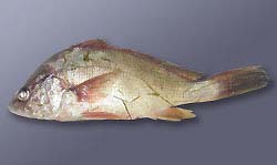
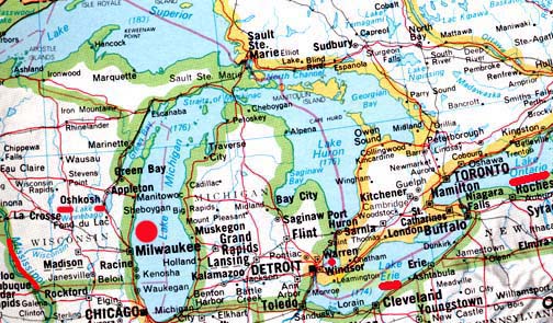
Hemorrhaging (bleeding) in the fins and eye of a freshwater drum believed to be infected with the VHS virus.The fish was collected from Little Lake Butte des Morts. Image courtesy Wisconsin Department of Natural Resources.Updated map: Lake Winnebago in eastern Wisconsin at Oshkosh, Lake Michigan, Lake St. Clair at Warren, Lake Erie and Lake Ontario (all highlighted with red in above map) have had metric tons of fresh water fish die from lethal viral hemorrhagic septicemia in 2005 through 2006; first die-offs of 2007 have now been reported to USGS. Authorities are trying to keep the virus from spreading to the other Great Lakes and into the Mississippi River (red underlined lower left) that extends south to New Orleans.
May 29, 2007 Madison, Wisconsin - The Wisconsin Department of Natural Resources reported on May 24, 2007, that a brown trout that died in Lake Michigan and washed ashore near the Kewaunee/ Algoma area preliminarily tested positive for viral hemorrhagic septicemia, or VHS. The University of Wisconsin-Madison Wisconsin Veterinary Diagnostic Laboratory conducted the preliminary test on the Lake Michigan trout. The sample has been sent to an Ames, Iowa, lab to confirm the VHS findings.The deadly fish disease also spread earlier this month to Lake Winnebago fish in eastern Wisconsin.
Click here to subscribe and get instant access to read this report.
Click here to check your existing subscription status.
May 25, 2007 Sequoia National Park, California, and Birmingham, Alabama - As the intensity has risen this week to explain away the Lake Tahoe, Capitola and Central California Chad images as Photoshop and/or "viral promotional films," I have interviewed a California resident who worked for the state government in the Department of Developmental Services in mental health for twenty-five years before recently retiring in 2006. Shirley was born in Ventura County, California, and earned her Psychiatric Technician degree from Ventura Community College in 1978. I have her full address, contact information and academic background, but she has applied to work in another state agency, so has asked to simply be identified as Shirley from the Central Valley of California. She does not want the chaos surrounding the images to affect her new employment. But she wanted the public to know that the Chad photos match a dragonfly-like aerial object she saw two years ago.
Click here to subscribe and get instant access to read this report.
Click here to check your existing subscription status.