Bird Eggs Undamaged in Slovenia Crop Formation

Ptuj, Slovenia, is marked by red circle, southeast of Graz Austria (yellow).

June 7, 2007  Ptuj, Slovenia - Today I received an email from Omer Sabic in Slovenia, a country bordered by Austria, Hungary, Croatia and Italy.


Click here to subscribe and get instant access to read this report.

Click here to check your existing subscription status.

Existing members, login below:

Part 3: U. S. Crop Formations, Wheat Pictogram in Madisonville, Tennessee

"The physical data knocks out the chance that people hoaxed this. People just cannot hoax the expulsion cavities and they cannot elongate the growth nodes..."

- Jeffrey Wilson, ICCRA

 Madisonville, Monroe County, Tennessee - site of the historic Cherokee nation's capital, Chota - is straight south of the Oak Ridge National Laboratory outside Knoxville and west of the Great Smoky Mountains.
Madisonville, Monroe County, Tennessee - site of the historic Cherokee nation's capital, Chota - is straight south of the Oak Ridge National Laboratory outside Knoxville and west of the Great Smoky Mountains.

Return to Part 1U. S. Crop Formations in Epps, Louisiana, and Red Bluff, Calif.

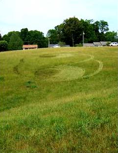
Return to  Part 2:  U. S. Crop Formations, Two Mysterious Grass Circles in Mission, Kansas.

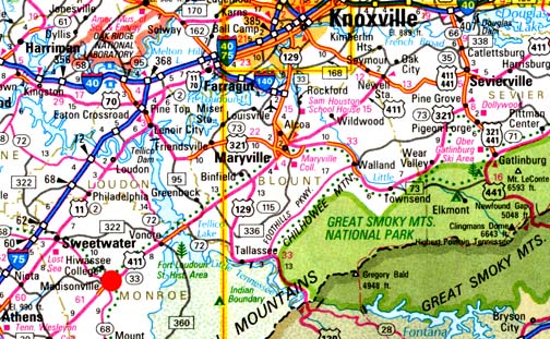
June 7, 2007  Williamsburg, Ohio   -  On May 24, 2007, I received a phone call from Jeffrey Wilson, Director of the Independent Crop Circle Research Association (ICCRA) in Williamsburg, Ohio, telling me that the Monroe County Buzz newspaper in Madisonville, Tennessee, had a headline about a crop formation in a wheat field. Madisonville, Monroe County, Tennessee - site of the historic Cherokee nation's capital, Chota - is straight south of the Oak Ridge National Laboratory outside Knoxville and west of the Great Smoky Mountains (red circle on map).


Click here to subscribe and get instant access to read this report.

Click here to check your existing subscription status.

Existing members, login below:

Part 2:  Yatesbury, England and Madisonville, Tennessee – A Mayan Link?

Top:  Yatesbury Field, Wiltshire, England, reported May 30, 2007, fifty-seven swirled barley circles in large spiral about 300 feet in diameter. Bottom: Madisonville, Tennessee, wheat pattern about 170 feet in diameter with crop laid down in counterclockwise circles discovered from airplane on May 15, 2007. U.K. aerial image © 2007 by Lucy Pringle. Tennessee aerial © 2007 by Mark Boring, Co-owner and Editor, Monroe County Buzz.

Return to Part 1: Yatesbury Spiral - Viewer Comments on Spiral Math

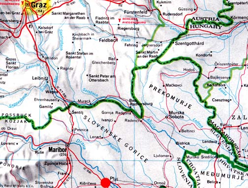
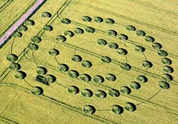
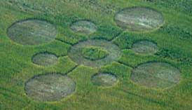
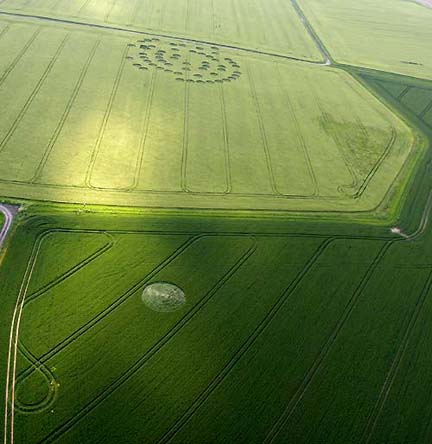
June 6, 2007  Yatesbury Field, Wiltshire, England - Two crop formations an ocean apart - one in English barley near the ancient and sacred ground of Avebury Trusloe on Yatesbury Field; the other in a Madisonville, Tennessee, wheat field not far from the historic Cherokee Indian capital of Chota and even more ancient 9,500-year-old Icehouse Bottom. (See Part 3: Madisonville Circles.)  The English pattern has fifty-seven circles threaded on a thin, 4-inch-diameter spiral. The Tennessee pattern has nine circles with a triangular "pointer" in the middle standing circle that aims west in the opposite direction from Chota.


Click here to subscribe and get instant access to read this report.

Click here to check your existing subscription status.

Existing members, login below:

Part 2: U. S. Crop Formations, Two Mysterious Grass Circles in Mission, Kansas

"Something has really knocked the heck out of the energy in the larger circle – and somewhat in the smaller circle."

- W. C. Levengood, Biophysicist

Monday, May 21, 2007, around 4 PM local time in Mission, Kansas, (suburb of Kansas City, Kansas), homeowner James Gravatt discovered two circles swirled in the high native grass of his unmowed front yard. Photograph © 2007 by James Gravatt.

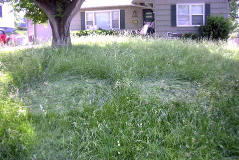
June 5, 2007, Earthfiles viewer's comment on the Mission, Kansas, grass circles:


Click here to subscribe and get instant access to read this report.

Click here to check your existing subscription status.

Existing members, login below:

Part 1: Yatesbury Spiral – Viewer Comments on Spiral Math

Reported May 30, 2007, 60-foot-diameter single circle in wheat near the barley spiral. Aerial image © 2007 by Peter white. Also see:  Cropcircleconnector.com.
Reported May 30, 2007, fifty-seven swirled barley circles in large spiral about 300 feet in diameter, Yatesbury Field near Avebury Trusloe, Wiltshire County, England, which is northeast of Calne. Aerial image © 2007 by Lucy Pringle. Also see:  Cropcircleconnector.com.

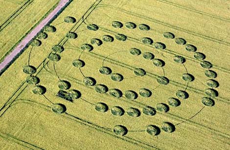
June 4, 2007  Albuquerque, New Mexico - So many Earthfiles readers today were provoked by the Yatesbury Field spiral "abacus" and the single circle in the other field that seems to reinforce the importance of the number "1" in the spiral counting. Among the many emails was communication from Chris Steele of ICCRA (Independent Crop Circle Research Association).


Click here to subscribe and get instant access to read this report.

Click here to check your existing subscription status.

Existing members, login below:

Part 1 – U. S. Crop Formations Near Indian and Ancient Earth Mounds

May 30, 2007  Albuquerque, New Mexico - Here begins an overview of five American crop formations, all in the month of May 2007. Each one is near Native American and ancient earth mounds reminiscent of the closeness that Wiltshire, England, crop formations also have to ancient stone circles and earth mounds.

May 27, 2007 - Asheville, North Carolina

Home of Cherokee Indians; many earth mounds west of Asheville. More upcoming in Part 4.

Asheville, North Carolina, resident Danny Tetrault sent in these photos of what he described as a crop circle he saw in West Asheville on Sunday, May 27, 2007. The grass formation can be seen off of North Bear Creek Road. Image © 2007 by Asheville Citizen-Times.
May 21, 2007 - Mission, Kansas (Suburb of Kansas City, Kansas)


Click here to subscribe and get instant access to read this report.

Click here to check your existing subscription status.

Existing members, login below:

Birmingham-Type “Drone” Seen At Barksdale AFB, Louisiana, in Mid-1980s


Click here to subscribe and get instant access to read this report.

Click here to check your existing subscription status.

Existing members, login below:

Deadly VHS Fish Virus Has Spread to Lake Michigan

Hemorrhaging (bleeding) in the fins and eye of a freshwater drum believed to be infected with the VHS virus.The fish was collected from Little Lake Butte des Morts. Image courtesy Wisconsin Department of Natural Resources.
Updated map: Lake Winnebago in eastern Wisconsin at Oshkosh, Lake Michigan, Lake St. Clair at Warren, Lake Erie and Lake Ontario (all highlighted with red in above map) have had metric tons of fresh water fish die from lethal viral hemorrhagic septicemia in 2005 through 2006; first die-offs of 2007 have now been reported to USGS. Authorities are trying to keep the virus from spreading to the other Great Lakes and into the Mississippi River (red underlined lower left) that extends south to New Orleans.

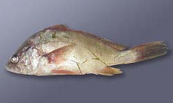
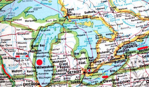
May 29, 2007  Madison, Wisconsin - The Wisconsin Department of Natural Resources reported on May 24, 2007, that a brown trout that died in Lake Michigan and washed ashore near the Kewaunee/ Algoma area preliminarily tested positive for viral hemorrhagic septicemia, or VHS. The University of Wisconsin-Madison Wisconsin Veterinary Diagnostic Laboratory conducted the preliminary test on the Lake Michigan trout. The sample has been sent to an Ames, Iowa, lab to confirm the VHS findings.The deadly fish disease also spread earlier this month to Lake Winnebago fish in eastern Wisconsin.


Click here to subscribe and get instant access to read this report.

Click here to check your existing subscription status.

Existing members, login below:

Two More Eyewitnesses of Aerial “Drones” in 2005 and 2006

“I’m told it’s some kind of communications device. It’s supposed to help the Park Service to monitor any possible problems like fires and such.”

- Sequoia National Park Ranger in Uniform, May 2005

Odd, aerial object above power poles near construction site in May 2006, in Birmingham, Alabama. Photo by Mr. Smith.

Click for Earthfiles Podcast.


Return to:  Birmingham-Type "Drone" Seen At Barksdale AFB, La., in Mid-1980s.

Return to:  Previous Odd Aerial "Drone?" Earthfiles.

Return to:  Engineer Comments About Odd Aerial "Drone?" Earthfiles.

Return to:  Odd Aerial "Drone"? Photographed Again Over Capitola, California.

Return to:  Letters About Unidentified "Drone" Aerial Objects.


May 25, 2007  Sequoia National Park, California, and Birmingham, Alabama - As the intensity has risen this week to explain away the Lake Tahoe, Capitola and Central California Chad images as Photoshop and/or "viral promotional films," I have interviewed a California resident who worked for the state government in the Department of Developmental Services in mental health for twenty-five years before recently retiring in 2006. Shirley was born in Ventura County, California, and earned her Psychiatric Technician degree from Ventura Community College in 1978. I have her full address, contact information and academic background, but she has applied to work in another state agency, so has asked to simply be identified as Shirley from the Central Valley of California. She does not want the chaos surrounding the images to affect her new employment. But she wanted the public to know that the Chad photos match a dragonfly-like aerial object she saw two years ago.


Click here to subscribe and get instant access to read this report.

Click here to check your existing subscription status.

Existing members, login below:

EARTHFILES