Bacillus anthracis, anthrax bacteria, can form stable spores that are resistant to harsh conditions and extreme temperatures. Photomicrograph courtesy University of Michigan.
Update - October 10, 2001 Boca Raton, Florida -
The third employee at American Media, Inc. in Boca Raton (Lantana), Florida has tested positive for exposure to an anthrax bacteria known as the Ames strain after an Ames, Iowa bacteria found in the tissue of a dead animal in the early 1950s. The other two cases are also the Ames strain which has been distributed over the past half century to many medical researchers to make anthrax vaccines. The 35-year-old woman is being treated with antibiotics. The FBI says there is no evidence to link the three anthrax cases to terrorists, but has now shifted its investigation to a criminal probe. The consensus is that the anthrax bacteria have an "unnatural source," which implies manipulation at least by someone with malicious criminal intent, if not terrorists.
Click here to subscribe and get instant access to read this report.
Click here to check your existing subscription status.
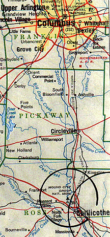
90-foot-diameter circle discovered entirely underground by magnetic sensing equipment at Chillicothe prehistoric Mound City Group National Monument about 40 miles south of Columbus, Ohio. Large earthworks of ditches, walls and mounds in circles, octagons, squares and rectangles were created by cultures that lived in the Ohio region. First known were the Adena (1000 B.C. to 200 A.D.) followed by the Hopewell (500 B. C. to 500 A.D.) The Adena and Hopewell did not leave any writings, so no one understands precisely why the large soil formations were created.
October 5, 2001 Chillicothe, Ohio - About 3,000 years ago, a culture that archaeologists call the "Adena" made great soil formations in Ohio and the greater Mississippi Valley. By 500 B. C., the Adena evolved into a subsequent culture that archaeologists call the "Hopewell" after an 18th Century farmer named Hopewell who owned the land near Chillicothe, Ohio upon which many mounds are concentrated. The ancient patterns include circles, octagons, squares and rectangles. When the Adena dug great round ditches and piled walls of soil along the edges, one of their favorite measurements for circles was a 90-foot-diameter. No one knows why.
Click here to subscribe and get instant access to read this report.
Click here to check your existing subscription status.
This false-color image from the Chandra X-Ray Observatory shows a central region of our Milky Way Galaxy about 24,000 light years from Earth known as Sagittarius A+. The bright, white central light source was produced by a huge X-ray flare thought to have occurred near a black hole at the center of our galaxy approximately 93 million miles in diameter. Chandra X-ray image courtesy NASA/MIT/F. Baganoff et al.
September 7, 2001 Cambridge, Massachusetts - MIT scientists have detected for the first time a rapid X-ray flare at the center of our Milky Way Galaxy near what is thought to be a supermassive black hole. The observation was on October 26-27, 2000, but not reported until the September 6, 2001 issue of Nature. The lead author, MIT's Frederick Baganoff, said, "This is extremely exciting because it's the first time we have seen in our own neighborhood a supermassive black hole devour a chunk of material. This signal comes from closer to the event horizon of our Galaxy's supermassive black hole than any that we have ever received before. It's as if the material sent us a postcard before it fell in."
Click here to subscribe and get instant access to read this report.
Click here to check your existing subscription status.
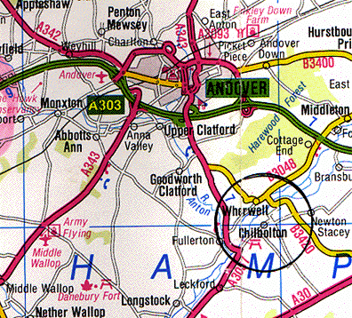
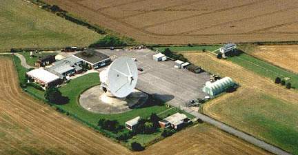
August 30, 2001 Chilbolton, Hampshire, England - On Tuesday, August 28, The Daily Mail finally published a news story with photographs by researcher and author, Lucy Pringle, about the controversial "face" and "binary code" in the wheat field next to the Chilbolton Observatory south of Andover, Hampshire. Chilbolton Observatory is a government-owned installation that was constructed in 1965 to study radio wave propagations from space and satellites and is owned and operated by the Rutherford-Appleton Laboratory under the U. K. Office of Science and Technology. Cereal crop fields that run along the barbed wire boundary of the Observatory are owned and operated by various farmers. The wheat in which the formations appeared is owned by the local Leckford Estate and by Wednesday, August 29, the Estate had cut down the "face" and "binary code" in its normal wheat harvest.
Click here to subscribe and get instant access to read this report.
Click here to check your existing subscription status.
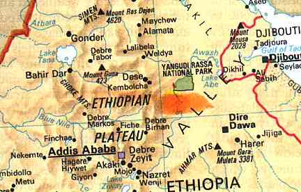
140 miles northeast of Ethiopia's capital, Addis Ababa, near the Awash River marked in orange, paleontologists have discovered bones of a primate dubbed Ardipithecus ramidus kadabba which might have been the first upright ancestor to human lineage 5.8 million years ago.
July 21, 2001 Alayla, Ethiopia - A graduate student named Yohannes Haile-Selassie studying paleontology at the University of California, Berkeley, found bones on December 16, 1997 at a site 140 miles northeast of Ethiopia's capital, Addis Ababa, Ethiopia which might be the missing link in evolving primates that went on to become humans. This creature, Ardipithecus ramidus kadabba, might have been the first primate to walk upright and the oldest human ancestor who lived in Ethiopian forests, not grassy plains, as far back as 5.8 million years ago. That's a million and a half years earlier than any other previous discovery and challenges the long held theory that primates stood up when they moved from trees to grassy plains.
Click here to subscribe and get instant access to read this report.
Click here to check your existing subscription status.
June 16, 2001 Washington, D. C. - Astronomer Gerald S. Hawkins, Ph.D., educated at Manchester University in England and now retired in Washington and Virginia, wrote a book in 1973 entitled Beyond Stonehenge. The Daily Express in London wrote about it, "If Hawkins is right, and most experts now agree that he must be, then Stonehenge is the Eighth Wonder of the ancient world."
Click here to subscribe and get instant access to read this report.
Click here to check your existing subscription status.
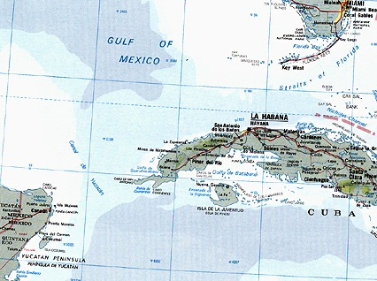
Western tip of Cuba, not far from the Yucatan Peninsula, where unusual sonar images at 2,200 feet suggest unnatural structures covering several square kilometers.
June 13, 2001 Havana, Cuba - When I reported last month on COAST about the Cuba discovery, I had an interview with Barbara Moffet, Director of Plans and Programs at the National Geographic Society in Washington, D. C., who confirmed that the Society was aware of the deep water mystery off the western tip of Cuba. She said NGS was communicating with Paulina Zelitsky and her husband, Paul Weinzweig, partners in Canada's Advanced Digital Communications company, known as ADC. Last month, National Geographic was trying to decide whether to help fund a dive in a remotely operated vehicle with cameras to see what is down there. Today, I talked again with Barbara Moffet and she confirmed that National Geographic has now made an agreement for exclusive magazine coverage.
Click here to subscribe and get instant access to read this report.
Click here to check your existing subscription status.
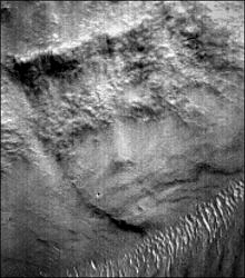
Malin Space Science Systems (MSSS) MOC narrow-angle image M02-03051 of unusual face-like surface feature in valley of Libya Montes near equator on Mars, approximately 275 degrees West and 2.66 degrees North. Image released by MSSS on May 22, 2000. To find this feature, it is necessary to turn the original MOC image upside down.
June 2, 2001 Tempe, Arizona - Unusual surface features on Mars imaged by the Global Surveyor continue to provoke controversy among scientists and civilians. One such image looks like a female face taken a year ago in May 2000 in the valley of Libya Montes near the Martian equator, but not publicized until the New York Post featured the image on May 9 after a press conference by astronomer Tom Van Flandern, Ph.D. and former astronaut Brian O'Leary. This week I discussed the face image with planetary geologist, David Nelson. Mr. Nelson is a Research Specialist in the Department of Geological Sciences at Arizona State University in Tempe. His current work is to study the Mars Global Surveyor images and to contribute ideas about where the next NASA Mars Excursion landing sites should be in January 2004. Two rovers are planned for that mission and one likely exploration site will be near sedimentary deposits in the walls of Valles Marineris, the 3000 mile long canyon that runs near the Martian equator.
Click here to subscribe and get instant access to read this report.
Click here to check your existing subscription status.
"We are the first people ever to see the bottom of Cuban waters over 50 meters...It's so exciting. We are discovering...even possibly a sunken city built in the pre-classic period and populated by an advanced civilization similar to the early Teotihuacan culture of Yucatan."
- Paulina Zelitsky, ocean engineer, Advanced Digital Communications, May 2001
At the western tip of Cuba at a depth of about 2,200 feet (700-800 meters), ocean engineer Paulina Zelitsky of Advanced Digital Communications reports large plateau with "shapes that resemble pyramids, roads and buildings."
May 18, 2001 Washington, D. C. - Reporter Andrew Cawthorne reporting from Havana, Cuba for Reuters bylined a May 15 story entitled "Explorers Comb Cuban Seas for Treasure, Mysteries." (See complete text below.) He interviewed ocean engineer Paulina Zelitsky, employed by Advanced Digital Communications and based in Tarara along the Cuba coast east of Havana. According to the article, Ms. Zelitsky said, "We are the first people ever to see the bottom of Cuban waters over 50 meters. It's so exciting. We are discovering ...even possibly a sunken city built in the pre-classic period and populated by an advanced civilization similar to the early Teotihuacan culture of Yucatan. ...Researchers using sonar equipment have discovered at a depth of about 2,200 feet (700-800 meters) a huge land plateau with clear images of what appears to be urban development partly covered by sand. From above, the shapes resemble pyramids, roads and buildings. "
Click here to subscribe and get instant access to read this report.
Click here to check your existing subscription status.
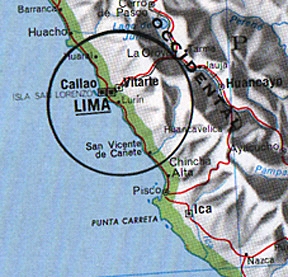
120 miles north of Lima, Peru is the Supe Valley archaeologists found ruins and mounds in 1905, but only now have scientists confirmed the site to be nearly 5,000 years old.
May 6, 2001 Caral, Peru - Archaeologists reported in the April 27, 2001 journal Science that the mounds and ruins in the Supe Valley 120 miles north of Lima are as old as the pyramids. Now Caral, Peru is the oldest city in the Western Hemisphere. Even though the site and seventeen others were first discovered in 1905, age was never precisely dated. Now Jonathan Haas, Curator of Anthropology at the Field Museum in Chicago and co-author of the report, says that disintegration of carbon in plant fibers in the ruin walls definitely date between 2627 B.C. and 2020 B. C. That makes the Peruvian Supe Valley home to a civilization as old and advanced as those in Egypt where the pyramids were being built, to Mesopotamia where the Sumerian culture dominated, to the Indus Valley, China and the newly discovered Central Asian civilization near Iran and Afghanistan which was making fine ceramics and had its own independent writing symbols. See: Earthfiles Science report 05-05-01.
Click here to subscribe and get instant access to read this report.
Click here to check your existing subscription status.