“Gobekli Tepe is a place of death; a place of re-birth. ... people who would enter into those enclosures ... and stand in between those two monoliths ... would quite literally be then projected out into the sky.”
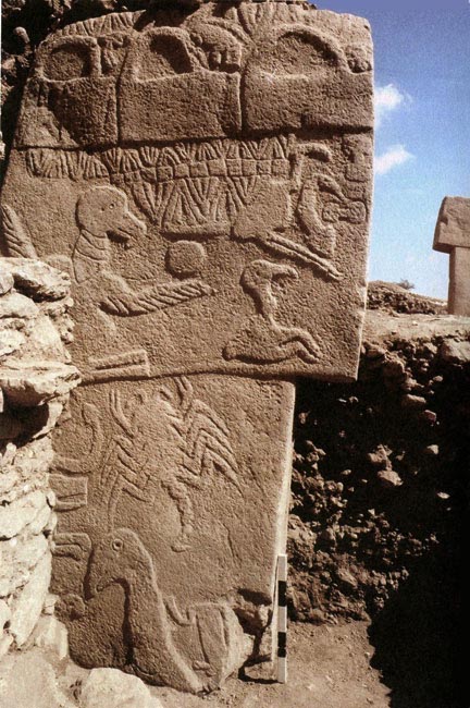
March 29, 2013 Gobekli Tepe 8 miles northeast of Sanliurfa, Turkey - Even though Gobekli Tepe is carbon dated to 12,000 years ago, there is one excavated stone pillar that has what looks like a bird with outstretched wings and a circular object that provokes comparison to the shen symbol of Egypt seven thousand years later.
12,000-year-old carved limestone pillar of layered symbols atGobekli Tepe excavation. Photo by Klaus Schmidt, Ph.D.
Click here to subscribe and get instant access to read this report.
Click here to check your existing subscription status.
— “Less than three acres of trees in Mexico were occupied by Monarch butterflies this winter - about 1/20th of what it has been in the past....The scale of the loss of habitat is so big that unless we compensate for it in some way, the Monarch population will decline to the point where it will disappear.”
- Chip Taylor, Ph.D., Prof. of Biology, Univ. of Kansas;
Founder and Director of Monarch Watch, Lawrence, Kansas
March 28, 2013Lawrence, Kansas - In the 1970s, Monsanto began producing the herbicide glyphosate, a broad leaf and grass weed killer called Roundup. Farmers liked it because it would kill many different types of weeds. Then Monsanto came up with genetically engineered corn and soybean crops that had their DNA altered to resist glyphosate. Farmers could now spray glyphosate everywhere without killing their corn and soybean crops. By 2007, glyphosate was the most used herbicide in United States agriculture. But what came next were “Superweeds” resistant to glyphosate. Monsanto scientists told farmers to simply apply more glyphosate.
Click here to subscribe and get instant access to read this report.
Click here to check your existing subscription status.
— “The sounds being heard are coming from the Earth itself. Changes deep inside the core are vibrating the crust near thin areas and causing the crust to act like a speaker most often times projecting deep waves up to the ionosphere where they are (bounced back) at audible frequencies... These inner ground vibrations are also what is causing the sink hole issue around the world... and underground water sources are being vibrated to the point of dispersion.”
- Retired electronics engineer 2005, Hill AFB, Utah
— “Then an explosion happened right in the middle of my living room that had the sound and force of an explosion with an after-sound of breaking glass.”
- Resident Anna Hoaglan, Woodland Hills, CA, March 7, 2013
— “This sounded like someone set off dynamite in front of my house.”
- Eddie Lashley, Louisville, Kentucky, on March 17, 2013
— “Why was the Civil Air Patrol Wing at Bowman Field, Kentucky, monitoring with a Cessna Skyhawk over Louisville from June through October 2012, for 6 to 8 hours a day on a classified mission?”
- Kentucky resident between Fort Knox and Louisville, Kentucky
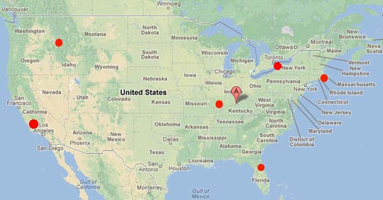
Strange sounds ranging from breaking glass and metal crashing to loud house and bone-rattling booms have been reported between March 7 - 23, 2013. In Woodland Hills, CA, (far left red circle) on March 7th, a resident reported sound of breaking glass sound at 3:30 PM Pacific. Loud booms were reported on March 13, in Tiverton and Little Compton, Rhode Island, and Westport, Massachusetts (far right red circle) that are 940 miles east of Louisville, KY (Google pointer). Between March 11-15, loud booms were heard in Alabama, NY, (red Great Lakes circle) between Lake Erie and Lake Ontario; March 16-17, loud booms in Kamiah, Idaho, 65 miles east of Lewiston (upper left red circle), is 2,102 miles northwest of Louisville that is straight east of southern Illinois and Indiana where loud booms were reported March 16-17 in all three states. Then on Thursday, March 21, 2013, near 9 PM EST, residents from several counties around Gainesville, Florida (north central Florida red circle) reported similar house-shaking, window-rattling.
Updated March 28 / Original report on March 19, 2013 Louisville, Kentucky - Since March 7, Earthfiles has received many more boom, light flash, military helicopter and higher strangeness sounds of metal crashing and glass breaking reports - but no physical evidence or known source. Here is a sampling:
Click here to subscribe and get instant access to read this report.
Click here to check your existing subscription status.
–“The west side of Gainesville flooded our communications center around 9 PM (March 21) with calls about a window-clattering and wall-shaking boom.”
- Sheriff's Lt. Art Forgey, Alachua County, Florida
– “USGS (U.S. Geological Survey) has not reported any earthquake activity in our area during that time (March 16), leaving the cause of these reports as somewhat of a mystery.”
- Ryan Buckingham, Director, Franklin County,
Illinois Emergency Management Agency
– “Anyone who had property damage from vibrations” reported from Louisville to Fort Knox, Kentucky, on March 17, 2013, “can file a claim with Fort Knox.”
- Fort Knox Army Base Press Release
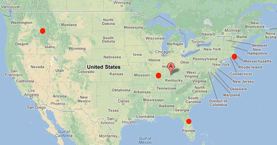
Loud house and bone-rattling booms were reported between March 13 - 17, 2013, in the following locations. Kamiah, Idaho, 65 miles east of Lewiston (upper left red circle) is 2,102 miles northwest of Louisville, Kentucky (Google pointer) that is straight east of southern Illinois boom reports. Tiverton and Little Compton, Rhode Island and Westport, Massachusetts (far right red circle) are 940 miles east of Louisville. Then on Thursday, March 21, 2013, near 9 PM EST, residents from several counties around Gainesville, Florida (north central Florida red circle) reported similar house-shaking, window-rattling.
March 23, 2013 Gainesville, Florida, and Southern Illinois - Residents in several counties in North Central Florida - including Alachua and Marion around Gainesville - were literally shaken on Thursday night, March 21, 2013, at around 9 PM EST. Hundreds of people called 911 and other authorities such as the Alachua County Sheriff's Office about hearing a loud boom that shook windows and walls. The Sheriff's Office contacted the Florida Division of Emergency Management's State Warning Point Office and was told that “military maneuvering of some kind” might be involved. But to date, no specific details have been confirmed by any military about who was doing what maneuvering in what location that would shake people in several north central Florida counties at the same time.
Click here to subscribe and get instant access to read this report.
Click here to check your existing subscription status.
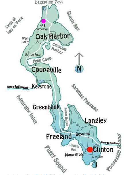
– “It was so hard to believe in broad daylight this happened when I had seen that cow and her 6-month-old calf both alive, well and feeding only hours earlier that morning. I’ve had animal deaths, but I’ve never had any kind of mutilation like this ever.”
- Diane Schneider, Farm Owner,
Clinton, South Whidbey Island, WA
– “I didn't see any bite marks or lacerations on the rear or throat, which rules out coyotes or a pack of dogs.”
- Carol Barnes, Whidbey Island Animal Control
Officer from Coupville, County Seat
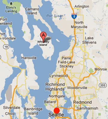
Whidbey Island is about 30 miles (48 km) north of Seattle in Puget Sound.Clinton, population 928, is located on the southern tip of Whidbey Island in Island County, Washington (red circle). Much of the village and surrounding farms are situated on a high bluff overlooking Saratoga Passage on Puget Sound. The Naval Air Station is at the northern end of Whidbey Island (pink circle).
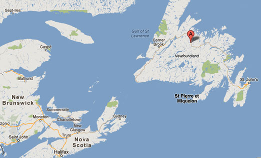
“We've looked all around (1st ice crater in Dawes Pond). There doesn't appear to beanything else that could have caused this except something that fell out of the sky.”
- Jim Gillard, Manager, Twillingate Astronomical
Observatory, Badger, Newfoundland
Strange “frozen waves” near the second crater in 2-foot-thick ice, this one at Powderhorn Lake, photogaphed by cabin owner Peter Butler on Sunday, March 10, 2013.Dawes Pond and Powerhorn Lake are about four miles apart at the Google map pointer near Badger, Newfoundland, Canada.
March 13, 2013 Dawes Pond and Powderhorn Lake, Badger, central Newfoundland, Canada - Two mysterious ice craters surrounded by odd, rising ice patterns that resemble frozen waves have been reported by cabin owners living about four miles apart, one on Dawes Pond and the second on Powderhorn Lake - both near Badger, Newfoundland, Canada.
Click here to subscribe and get instant access to read this report.
Click here to check your existing subscription status.
“The non-human being was depicted with a large nose, large eyes with vertical pupils, a layered headdress, which curved aroundlarge ears. The being held a rod in its left hand that was wound with a helix-shaped coil.”
Left: Is the big-nosed being wearing a ropey headdress and holding an alleged communication rod in 1964 a “Cloned Biological Entity (CBE)”? If so, was the Sumerian sun god Shamash on right, who is also wearing a ropey headdress and holding a rod, also a CBE? Illustration on left from 1974 edition of UFOS: Past, Present & Future by Robert Emenegger and Allan F. Sandler. Carving on right from 1772 B. C., Sumerian sun god Shamash in Hammurabi Stele currently on display in The Louvre, Paris.
March 11, 2013 Albuquerque, New Mexico - RELEASE 27a - Reagan Briefing is described as a “Transcript of classified tape recording made at Camp David, Maryland, during a presidential briefing regarding the subject of UNIDENTIFIED FLYING OBJECTS and EXTRATERRESTRIAL VISITATION of Earth. President RONALD REAGAN was present. The recording was made between March 6 and 8, 1981.”
Click here to subscribe and get instant access to read this report.
Click here to check your existing subscription status.
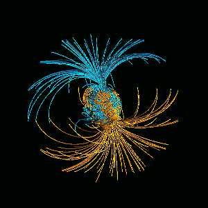
March 10, 2003 Cambridge, Massachusetts - Four thousand miles down below our planet's surface is the center of the earth's iron core, depicted as brown in the illustration below. There is so much pressure there that the iron is hard from the center outward for about 746 miles (1200 km). But then it begins to melt and flow like porridge cooking in the yellow area that pushes upward as orange magma. That moving, melted iron also produces the magnetic fields that surround the earth and upon which much of earth's surface life, satellites and space technology depend upon for orientation and for protection. If magnetic fields did not trap highly energetic particles racing from the sun, all kinds of damage could be done to living organisms and space technologies.
Click here to subscribe and get instant access to read this report.
Click here to check your existing subscription status.
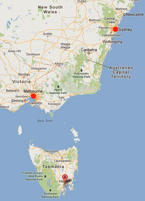
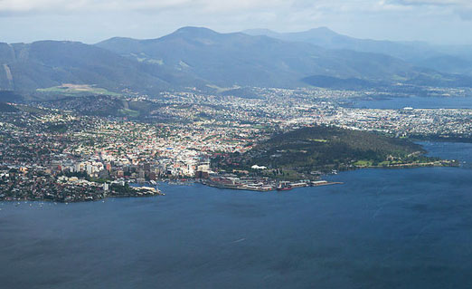
“Once we put the (Hobart, Tasmania) fire out, we kind of walked through the fire and tried to find something. We thought a flare or something might have landed there, but we could not find any (flare) or cause.”
March 10, 2013 Hobart, Tasmania - Early Saturday morning, March 2, 2013, something happened on a dry grass hill in Hobart, Tasmania, that caused a localized fire shown in an Australian Broadcasting Corporation News photo below. Even though there is a strict ban on fireworks in Tasmania because of the fire hazard in their 2013 hot, summer drought, officials speculated the cause was somebody's fireworks. But not confirmed.
Click here to subscribe and get instant access to read this report.
Click here to check your existing subscription status.
– “These USAF humvees were equipped with a satellite-looking
apparatus that would fold out and emit a huge sound wave that
he said ‘when it hit a tank, it would liquefy the occupants.’”
- Oregon resident
– “Starting with the Second World War, there was a division of the U.S. Army that was referred to as the Ghost Army. Part of what they were involved in was sonic deception, putting loud speakers in the battlefield to create a false impression. ... the U.S. Army in Vietnam had a division of psychological operations called Wandering Soul. This involved helicopter-mounted loudspeakers playing simulated Buddhist chants, fabricated sounds of the dead ancestors of the Viet Cong fighters speaking to them from the afterlife to try and persuade them to surrender. ... now is the use of ultrasound driven directional audio speakers that can actually rupture eardrums from a distance.”
- Steve Goodman, Hyperdub and
2009 author of Sonic Warfare, London, England
Updated: Original March 8, 2013 Albuquerque, New Mexico - The following is correspondence to Earthfiles.com about the “sound gun” technology that I first reported in this news website's “Mysterious Booms - A Secret Military Weapon?” and on Coast to Coast AM radio March 1, 2013.
UPDATE March 10, 2013: Earthfiles has received several references to sonic warfare with Ultrasonic Weapons (USW) - outside human hearing - and Long Range Acoustic Devices (LRAD), in which sound is used to cause pain in crowd control and other applications and can damage ear drums within 49 feet (15 meters), according to LRAD Corporation officials.
The Long Range Acoustic Device (LRAD) is a sonic weapon developed by LRAD Corporation to send messages, warnings, and harmful, pain-inducing tones over longer distances than normal loudspeakers. LRAD Corporation was formerly named American Technology Corporation. In 2004, Carl Gruenler, a former vice president of military and government operations for American Technology Corporation said that being within 100 meters (330 ft) of the LRAD is extremely painful, and that it was designed for use in short bursts at 300 meters (980 ft), to give targeted people a headache. He said that “you definitely don't want to be” within 100 meters (328 feet); the device will cause permanent auditory damage and can damage ear drums within 49 feet (15 meters). Image of Navy man holding an LRAD weapon on USS Typhoon, stationed at Naval Amphibious Base Little Creek, January 13, 2006. Image source: U. S. Navy and Wikipedia.
Click here to subscribe and get instant access to read this report.
Click here to check your existing subscription status.