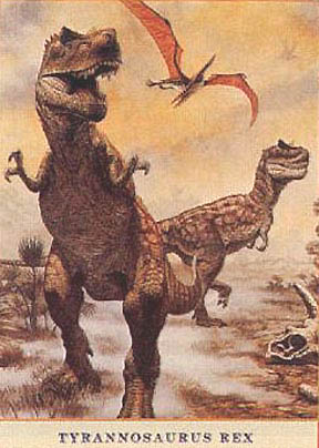
Spirit Rover Finds Magnesium Sulfate Near “Larry’s Lookout” in Columbia Hills on Mars.

March 26, 2005   Albuquerque, New Mexico - Earthfiles is staying in touch with Larry Crumpler, Ph. D., Mars Spirit Rover Mission and Research Curator, who receives data from Spirit and designs maps based on rover data. Dr. Crumpler is based in the Volcanology and Space Science Department at the New Mexico Museum of Natural History and Science in Albuquerque, New Mexico. He is the scientist after whom "Larry's Lookout" was named in the Gusev Crater's Columbia Hills.

This week he emailed me twice about Spirit's long trek across the Columbia Hills and included the stunning image of Martian soil rich in magnesium sulfate. No question that Mars was wetter when the Columbia Hills rocks were deposited before the Martian climate suddenly changed very early in the red planet's history to greater dryness. See more information in Earthfiles 022505. 

Larry Crumpler, Ph.D., Planetary Scientist and member of NASA Mars Spirit Rover team. Dr. Crumpler is also Research Curator for Volcanology and Space Science at the New Mexico Museum of Natural History and Science in Albuquerque, New Mexico. Photograph © 2005 by Linda Moulton Howe.


Click here to subscribe and get instant access to read this report.

Click here to check your existing subscription status.

Existing members, login below:

Glow of Distant Worlds Seen For First Time

"...we are on the verge of finding evidence for other Earth-like planets in the neighborhood of our galaxy. That is really an incredibly profound advance in science."

- Alan Ball, Ph.D., Carnegie Institution

Infrared detection not currently in image form, so this is artist's version of what the distant worlds might look like in infrared. Artwork courtesy NASA/JPL-Caltech/R. Hurt.

 March 25, 2005   Washington, D. C - NASA's Spitzer Space Telescope, launched in August 2003, is the largest infrared telescope ever placed in space to orbit the sun. Now, for the first time, the Spitzer Space Telescope has captured the light and heat from two planets orbiting very distant stars, one 150 light years away and the other 500 light-years. The findings mark the beginning of a new age for planetary science, in which "extrasolar" planets can be directly measured and compared. In order for the Spitzer telescope to see the heat from such distant planets, the telescope must be cooled to near absolute zero (-459 degrees Fahrenheit or -273 degrees Celsius) so that it can observe infrared signals from space without interference from the telescope's own heat. Also, the telescope must be protected from our Sun's heat and the infrared radiation put out by the Earth. To do this, Spitzer carries a solar shield and was launched into a special orbit which places Spitzer far enough away from the Earth to allow the telescope to stay cold without having to carry large amounts of cryogen coolant. 


Click here to subscribe and get instant access to read this report.

Click here to check your existing subscription status.

Existing members, login below:

Part 6: UFO Crash/Retrievals: Status Report III – Amassing The Evidence

"After lengthy interrogation by Naval Intelligence, OSS and the FBI, who had been called in, E. L. was forced to surrender the so-called Black Box and to designate the location of the alien craft."

- Source: WWII Vet, 1944, Kaneohe, Oahu, Hawaii 

Return to Part 1

To be more computer-friendly, the reprint has been divided into parts. Here begins Part 6 of Status Report III, written in June 1982. The series of status reports, I through VII, were written by Leonard H. Stringfield from 1978 to 1994. Previous Status Report IV begins at Earthfiles 021205. Leonard Stringfield died on December 18, 1994.

CASE A-11: 1965, Air Force Museum, Fairborn, Ohio:

The Air Force Museum is in Fairborn, Ohio, near Dayton. Fairborn is also the location for Wright-Patterson AFB.


Click here to subscribe and get instant access to read this report.

Click here to check your existing subscription status.

Existing members, login below:

Part 5: UFO Crash/Retrievals: Status Report III – Amassing The Evidence

"...[On Papago Indian Reservation west of Tucson, Arizona] military personnel were about a quarter of a mile away grouped around an object that appeared to be half sunk in the sand. A disc-shaped object with a dome on top was about 30 feet in diameter and 18 feet high. On its outer edge were two rings which seemed to have windows between."

- Eyewitness, U. S. Navy, January 1947

Return to Part 1

To be more computer-friendly, the reprint has been divided into parts. Here begins Part 5 of Status Report III, written in June 1982. The series of status reports, I through VII, were written by Leonard H. Stringfield from 1978 to 1994. Previous Status Report IV begins at Earthfiles 021205. Leonard Stringfield died on December 18, 1994.

Tommy Blann, March 30, 1982:

Early 1970s - UFO Project At Fort Hood, Texas?

"'In the latter part of 1973, the entire Southeastern section of the U. S. was undergoing a wave of UFO sightings. The Central Texas area had an unusually large number of reports coming out of the farming communities around Calvert, Bremond, Temple and a few other small towns which are east of Fort Hood. 


Click here to subscribe and get instant access to read this report.

Click here to check your existing subscription status.

Existing members, login below:

Astronaut John Young: “The Moon Can Save Earth’s Civilization.”

"NASA is not about the 'Adventure of Human Space Exploration.' We are in the deadly serious business of saving the species. I think over this century if we industrialize the moon and use its resources, I think it can save civilization. I think over the long haul, going to Mars will extend civilization. But I think the moon has the capability to save us." ­

Astronaut John Young, Captain, Apollo 16 Flight to the Moon

North America land mass amid the Earth's oceans and clouds in image taken from Apollo 16 after launch on April 16, 1972. Commander was astronaut John W. Young with his crew, Thomas Mattingly and Charles Duke. Apollo 16 returned in ocean splashdown on April 27, 1972. Earth image courtesy NASA.
NASA Apollo 16 crew, the tenth manned Apollo mission, April 16-27, 1972. L-R: Thomas K. Mattingly, II; Commander John W. Young; Charles M. Duke, Jr. -


Click here to subscribe and get instant access to read this report.

Click here to check your existing subscription status.

Existing members, login below:

Part 4: UFO Crash/Retrievals: Status Report III – Amassing The Evidence

"Within Fort Hood is Gray AAF, known as Robert Gray Field, where AF personnel are attached while at Fort Hood. ...a pilot had to make a forced landing on a dusty field (at Gray) and the next thing he saw was an approaching jeep with armed MPs ... and a huge section of land separating like 'giant sliding doors' with vegetation intact revealing a huge corridor inside."

- USAF Captain Stationed at Fort Hood, Central Texas

Return to Part 1

To be more computer-friendly, the reprint has been divided into parts. Here begins Part 4 of Status Report III, written in June 1982. The series of status reports, I through VII, were written by Leonard H. Stringfield from 1978 to 1994. Previous Status Report IV begins at Earthfiles 021205. Leonard Stringfield died on December 18, 1994.


Click here to subscribe and get instant access to read this report.

Click here to check your existing subscription status.

Existing members, login below:

Could Avian Flu H5N1 Cause the Next Pandemic?

“I can certainly say the risk is huge! Certainly the H5N1 virus that is out there is a particularly nasty virus. If you want to rank the flu viruses that you don’t want in the human population, this guy is right at the top. The potential (threat) is huge. But exactly what the risk is in terms of this virus going human-to-human, nobody actually has any idea.”

– Richard Webby, Ph.D., Microbiologist and Influenza Virus Specialist

Tuesday, February 22, 2005, Albuquerque Journal. 
Tuesday, February 22, 2005, Albuquerque Journal.

March 12, 2005  Memphis, Tennessee – For the past several weeks, the Director of the Centers for Disease Control and Prevention in Atlanta has made announcements about CDC’s concern that the avian flu virus in Asia, also known as “bird flu,” could be the source for the world’s next dangerous pandemic in the human population. In fact, CDC and the World Health Organization say they are trying with urgency to develop a vaccine that could be ready if the avian flu virus, known as H5N1, expands its host territory from chickens and ducks to transmission human-to-human.Click for report.

Juan de Fuca Ridge: 4,000 Small Quakes West of Vancouver Island, Feb. 27 – Mar. 4.

One hundred miles west of the Strait of Juan de Fuca and Vancouver Island, British Columbia, Canada, 4,000 small earthquakes swarmed between February 27 and March 4, 2005. There, the Juan de Fuca Plate moves downward below the North American Plate along the seismically active Ring of Fire. A large motion downward of the Juan de Fuca Plate could push the North American Plate violently upward in a major earthquake and possibly Indonesia-sized tsunami.

March 10, 2005  Newport, Oregon – An abnormally large number of small earthquakes swarmed in the Juan de Fuca region off Vancouver Island, British Columbia, Canada, between February and March 4. Then on March 8, 2005, Mount St. Helens released a 30,000-foot-high plume of gas and ash. Offshore, U. S. Navy hydrophones picked up at least 4,000 low magnitude rumblings over six days, which provoked university and NOAA scientists to recently dive down to the sea floor to check out what was happening. Of all the seismic regions off shore around the continental United States, the Juan de Fuca ridge is one that could have a subduction event in which plates violently slide over each other as they did in the huge December Indonesian event. If that did happen in Juan de Fuca, there could be a very large tsunami as well.Click for report.

Flying Disc Paced Airliner Over Puget Sound Navy Yard

Puget Sound Navy Ship Yard near Bremerton, Washington, west of Seattle.

March 7, 2005  Shelton, Washington - Jim Strong's interest in unidentified flying objects began during his U. S. Air Force work from February 1964 to February 1968. He was trained at Keesler Technical Training Center in Biloxi, Mississippi, in advanced electronics and radar. Then he was stationed with the 757 Radar Squadron at Blaine AFB on the Canadian border. Once there, Jim was assigned to the Search Radar unit. [Editor's Note: In search radar, the antenna goes around in a circle and picks off the azimuth, or direction, of aircraft. In height finder radar, the antenna nods up and down.]


Click here to subscribe and get instant access to read this report.

Click here to check your existing subscription status.

Existing members, login below: