


August 29, 2000 Woodburn, Oregon - Yesterday I received the photograph above in an e-mail from Helen Bibelheimer of Keizer, Oregon. She wrote:

August 29, 2000 Woodburn, Oregon - Yesterday I received the photograph above in an e-mail from Helen Bibelheimer of Keizer, Oregon. She wrote:
"In Poland, some reported an unearthly glow above the fields the night the circles appeared."
- Deutsche Press-Agentur (dpa)
COMPARE TO:
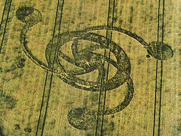
August 27, 2000 Whitefish, Montana - This is the third year in a row that a crop formation in wheat has appeared in Whitefish, Montana in the first half of August. When pilot Gilbert Johnson flew over the latest formation on August 15th, he might have been the first to discover and photograph it. The next day on August 16th, Mary and Larry Johnson, who own a health food store in town, saw the formation from Church Avenue near trees that completely obscured the pictogram from nearby and well-traveled Highway 93. The couple asked the farm owners for permission to enter and told people in town about it. Melody Watts, who runs a convenience store in Whitefish and investigated the formation in Whitefish last year, heard about the new formation while driving back from a vacation on August 20th. She was so excited, she first went to the farm owner for permission to get into the new formation before even driving home. Then she returned in the evening.
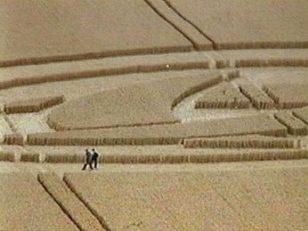
August 26, 2000 East Field, Wiltshire, England – On Monday, July 31st late in the evening, crop circle researchers Ed and Kris Sherwood were in an East Kennett crop formation when a bright yellow unidentified aerial object appeared followed immediately by a loud, military-type helicopter that nearly ran them down in the field. After the couple went to the ground to escape the low-flying helicopter, it pursued the bright yellow object again, both disappearing behind a hill. Then a second bright yellow aerial object appeared. The Sherwoods videotaped the helicopter and yellow object and learned that other people did, too. Frank Laumen, a researcher and photographer from Germany, was at the bridge in Allington and could see lights and a helicopter back toward East Kennett. He videotaped the interactions. Andy Buckley from Manchester, England was also on Martinsell Hill and videotaped helicopter and light activity about the same time.Click for report.
"I felt an orange light was homing in on me and communicating with my brain or trying to take something out of my brain."
- Hazel, friend of Andy Buckley, August 12, 2000
August 23, 2000 Wilcot, Wiltshire, England - On August 12, 2000 before we climbed Woodborough Hill to watch for mysterious lights, graphic artist, Andy Buckley, and his partner, Hazel, and I met at The Golden Swan pub in Wilcot, Wiltshire to talk about the intelligence in the mysterious lights each has sensed the past few years. Andy has a dozen videotapes of light phenomena associated with the crop formations, both day and night.
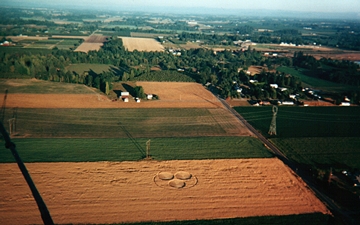
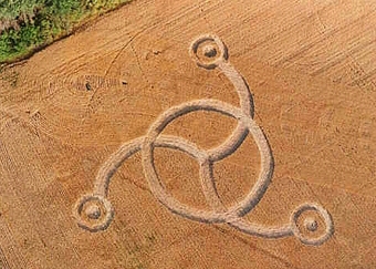
August 20, 2000 Langdon, North Dakota - Today I talked with crop duster pilot, John Boe, who has been flying and spraying cereal crops for the past seven years around Langdon, North Dakota - a farming community near the Canada and Minnesota borders. Last month, on July 20th, he was flying over the Janelle and Randy Bata farm three miles west of Langdon when he saw what looked like a tinkertoy of half a dozen circles connected by a path in a wheat field.
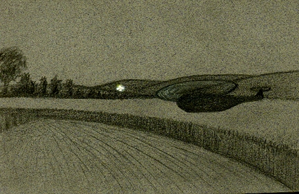
August 20, 2000 East Kennett, Wiltshire, England - This weekend I learned from crop circle researchers, Ed and Kris Sherwood of Millennium Research in Santa Monica, California, that when they were in Wiltshire this summer doing a meditation experiment, the couple had a close encounter with a helicopter and two unidentified aerial craft. The date was July 31st around 11:30 PM and the location was the East Kennett square inside a circle formation. Part of their meditation experiment was psychic photography, to photograph with a flash camera the air around them in an effort to capture images of luminosities and translucent spheres that increasing numbers of people have photographed the past several years. The exact source of the images is still a mystery. Their camera was flashing in the darkness when they first heard a loud helicopter approaching.
August 17, 2000 Woodborough Hill, Near Alton Priors, Wiltshire, England - This past Saturday night of August 12, 2000, around 10:30 PM, three of us had climbed Wiltshire's famous Woodborough Hill which has been a central focus for crop formations since the phenomenon seriously began on a global scale in 1990. With me was Andrew J. Buckley, a graphic artist from Manchester, England, and his friend, Hazel. Andy had videotaped six small, white, glowing lights moving over the wheat field between Woodborough Hill and Pickled Hill on July 18th and wanted to visit again to see if any more would turn up.
July 16, 2000 Wiltshire, England - In the past week, there have been nearly a dozen formations in southern England and five of them emerged between July 15 to 16. Charles Mallett and his wife, Frances, have been studying, photographing and drawing crop formations in England for some time and produce a great web secton at the cropcircleconnector.com called C& F Phenomenon. I talked with Charles this afternoon about what happened this weekend.