Greenland Sea Cold Water Re-Cycling Has Nearly Stopped. Britain Expected to Become Cooler.

“We do expect that this reduction in the volume of sinking water (in Greenland Sea) will lead to a reduction in the volume of warm water reaching Europe. That will cool down Europe ­ or at least parts of Europe that are accessible to the ocean. … (England and coastal parts of Europe) will be getting more violent types of weather that are due to the higher temperature differences that are happening everywhere.” ­

– Ocean Physicist Peter Wadhams, Cambridge University, U. K.

Labrador and the British Isles are on the same latitude. But Britain has enjoyed a mild climate compared to cold Labrador because of the North Atlantic Drift, also known as the Atlantic Thermohaline Circulation, which conveys warm equatorial water to the U. K. and Faeroe Islands.

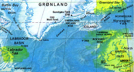
 May 11, 2005  Cambridge, England – Normally in the Atlantic Ocean, warm water moves from the Equator up to the British Isles, keeping England and parts of Europe warmer than Labrador which is at the same northern latitude. The warming is caused by a huge convection process called the Atlantic Thermohaline Circulation, or North Atlantic Drift. Equatorial warm water is circulated to the Labrador Sea and Greenland Sea, cools off, and then sea ice forms. The ice does not take up the sea salt which is left behind in the ocean and makes the water denser and it sinks. For more than a century, at least a dozen cylinder-shaped columns of cold water have been sinking into the deep ocean and heading back south toward the Equator which has kept the big conveyor belt of warm-to-cold-to-warm water going in the Atlantic Ocean.Click for report.

Mysterious Lights and 2003 Serpent Mound Soybean Formation

“All of us agreed that the mysterious lights seemed to be coming from the direction of the Serpent Mound area, which from my sister’s house would have been off to the right in our field of vision. We actually joked at the time, ‘Maybe there will be a crop circle there in the morning.’”

– Tree Pruitt, Eyewitness, Batavia, Ohio

Photograph of ancient Serpent Mound near Locust Grove and Peebles, Ohio. Mound is 800 meters long (.5 miles) and its construction is placed around 800 A.D. Soybean formation was 3,000 feet ( a little more than a half mile) to the east of the serpent's tail shown at left of photo. Image courtesy Planetary and Space Science Centre, University of New Brunswick.
Photograph of ancient Serpent Mound near Locust Grove and Peebles, Ohio. Mound is 800 meters long (.5 miles) and its construction is placed around 800 A.D. Soybean formation was 3,000 feet ( a little more than a half mile) to the east of the serpent’s tail shown at left of photo. Image courtesy Planetary and Space Science Centre, University of New Brunswick.
Arrow points at the soybean formation through early morning mist. Thin black line extends from the formation to lower right beige clearing which is the tail of the Serpent Mound.  Aerial photograph © 2003 by Jeffrey Wilson and Roger Sugden.
Serpent Mound soybean formation first discovered August 24, 2003, was 271 feet from top of large ring to bottom of small, ringed circle, all oriented east to west. The diameter of the "Eye" in the Vesica Piscis was 74 feet. Aerial photograph © 2003 by Jeffrey Wilson and Roger Sugden.
Serpent Mound soybean formation first discovered August 24, 2003, was 271 feet from top of large ring to bottom of small, ringed circle, all oriented east to west. The diameter of the “Eye” in the Vesica Piscis was 74 feet.
Aerial photograph © 2003 by Jeffrey Wilson and Roger Sugden.

May 9, 2005  Batvia, Ohio – Two years ago, between August and November 2003, four crop formations in soybeans were reported in the mysterious and ancient mound-builder’s region of southern Ohio. Most important in terms of plant and soil anomalies was the first one discovered on the morning of August 24, 2003, not far from the famous Serpent Mound near Locust Grove, Ohio. The tall soybean plants had been laid down in a geometry based around the Vesica Pisces symbol found so often in British crop formations. Its longest length was 271 feet and there were no tracks around the entire perimeter or inside the extraordinary pattern.Click for report.

Updated – More Than 1,000 Cane Toads Explode to Death in Germany and Denmark

Exploding cane toads have been reported on April 25, 2005, at Lake Mosehullet, Middle Jutland near Laasby in Denmark, northwest of Copenhagen.
Originally native to Venezuela, cane toads have poisonous sacs on the back of their heads which can kill crocodiles, snakes and other animals in minutes. Photograph courtesy of USGS.

April 27, 2005  Hamburg, Germany – At first, the idea that poisonous cane toads originally from Venezuela, South America would crawl out of a lake near Hamburg, Germany, and explode to death, sounds like a Monty Python comedy.Click for report.

“Battle of Los Angeles” On February 25, 1942: When America’s 37th Coast Artillery Brigade Fired Anti-Aircraft Shells At A UFO

When America’s 37th Coast Artillery Brigade fired off 1,430 anti-aircraft shells at a diamond-shaped craft of unknown origin.

Actual photograph taken of eight search lights aimed by American anti-aircraft batteries at an unidentified object or objects during the “Battle of Los Angeles” some time after 3:06 a.m. Pacific, February 25, 1942, over Santa Monica Mountains near Los Angeles, California. Photographer, Mr. Calvert.
Los Angeles Times Front Page, February 25, 1942, after early morning anti-aircraft artillery fire on unidentified aerial object over Santa Monica Mountains near Los Angeles, California. 
Los Angeles Times Front Page, February 25, 1942, after early morning anti-aircraft artillery fire on unidentified aerial object over Santa Monica Mountains near Los Angeles, California.

April 14, 2005  Los Angeles, California – Sixty three years ago on February 24-25, 1942, all of southern California from the San Joaquin Valley to the Mexico border was blacked out. Fearing a WWII Japanese invasion attack after Pearl Harbor on December 7, 1941, air raid sirens had gone on and off the evening of February 24, as intermittent unidentified aerial lights were reported. Then at 2:25 a.m. on February 25, most of the greater Los Angeles region’s three million population was awakened by loud air raid sirens that kept wailing for the next thirty-eight minutes. Powerful searchlights were aimed at a glowing unidentified aerial object over the Santa Monica Mountains that was shaped like a “lozenge.” Then America’s 37th Coast Artillery Brigade fired off 1,430 anti-aircraft shells at the unidentified aerial, diamond-shaped craft.Click for report.

First 2005 Dutch Crop Circles Reported in Hoeven, Holland Grass

Hoeven, Holland, is a small farming community marked by the red star near Roosendaal, south of Rotterdam. Map © MapQuest.

April 12, 2005  Brummen, The Netherlands – Seven years ago on June 7, 1999, a few minutes after midnight, 19-year-old Robbert van den Broeke woke up and felt compelled to look out his second story bedroom window. Robbert opened the curtains and saw a “small, misty, pinkish-purple light” shaped like a football coming over the wheat field at a height of about ten feet. The light stopped about 150 feet from his house. “Then the light started to elongate, spreading out becoming thinner and thinner looking like a disc. When it was about thirty feet in diameter, Robbert saw what he called “electrical discharges” emit from the bottom of the pinkish-purple light. After that, the light faded away. Robbert ran outside into the wheat and there was a 30-foot-diameter circle next to a 10-foot-diameter circle.

Click for report.

Highly Strange Dog Death in Arkansas; 2000-Pound Bull Dropped On Log Pile and Calf Skinned

Rancher Ricky Lummus and his family have 90 acres between Bloomburg, Texas, and Doddridge, Miller County, Arkansas, near the "T-border" where Texas, Louisiana, and Arkansas come together. Hope and Ashdown, Arkansas, circled in black on the map, are areas of animal mutilation reports over the past several decades.
Rancher Ricky Lummus and his family have 90 acres between Bloomburg, Texas, and Doddridge, Miller County, Arkansas, near the “T-border” where Texas, Louisiana, and Arkansas come together. Hope and Ashdown, Arkansas, circled in black on the map, are areas of animal mutilation reports over the past several decades.

April 12, 2005  Doddridge, Arkansas – Rancher Ricky Lummus is 43-years-old. He has been raising animals for half his life. Nine years ago, he and his family moved on to 90 acres in southwestern Arkansas between Bloomberg, Texas, and Doddridge, Arkansas, very near the “T-border” where Texas, Arkansas and Louisiana come together. He runs his cattle with cow dogs. Recently he added two male puppies about two-months-old to his other five dogs for a total of seven.Click for report.

Chronic Wasting Disease Has Spread to New York State Captive Deer

“If it was a positive CWD animal, I would not eat it. In the infectious prion form, we hope the species barrier will protect us. But the recent history of BSE (Mad Cow) suggests it has not.”

– Srinand Sreevatasan, D.V.M., Univ. of Minnesota

Oneida County, New York, where Utica is the County Seat.

 April 7, 2005  Albany, New York – This week on April 2, 2005, a second case of Chronic Wasting Disease was confirmed in a white-tailed deer farm in Oneida County, New York State. Utica is the county seat. The week before, the first case was reported by New York’s Department of Agriculture and Markets and the New York Dept. of Environmental Conservation (DEC).Click for report.

U. N. Reports Earth’s Ecosystem Deteriorating Rapidly – Will Humans Change Bleak Future?

“This (U. N.) report is essentially an audit of nature’s economy, and the audit shows we’ve driven most of the accounts into the red.”

– Jonathan Lash, World Resources Institute

March 31, 2005 Washington, D. C. –  This week, the United Nation’s Millennium Ecosystem Assessment program held press conferences in London, Washington, D.C., Tokyo, Beijing, New Delhi, Brasilia, Cairo, Nairobi and Rome to announce results from an unprecedented study of the Earth’s ecosystem by more than 1300 scientists from 95 countries that began in 2001. The current data is sobering. Fifteen of the twenty-four services the assessment analyzed have degraded – most notably fresh air and water, fisheries, water purification, forests, other habitats and the regulation of climate, natural hazards and pests. Click for report.

Could Avian Flu H5N1 Cause the Next Pandemic?

“I can certainly say the risk is huge! Certainly the H5N1 virus that is out there is a particularly nasty virus. If you want to rank the flu viruses that you don’t want in the human population, this guy is right at the top. The potential (threat) is huge. But exactly what the risk is in terms of this virus going human-to-human, nobody actually has any idea.”

– Richard Webby, Ph.D., Microbiologist and Influenza Virus Specialist

Tuesday, February 22, 2005, Albuquerque Journal. 
Tuesday, February 22, 2005, Albuquerque Journal.

March 12, 2005  Memphis, Tennessee – For the past several weeks, the Director of the Centers for Disease Control and Prevention in Atlanta has made announcements about CDC’s concern that the avian flu virus in Asia, also known as “bird flu,” could be the source for the world’s next dangerous pandemic in the human population. In fact, CDC and the World Health Organization say they are trying with urgency to develop a vaccine that could be ready if the avian flu virus, known as H5N1, expands its host territory from chickens and ducks to transmission human-to-human.Click for report.

Juan de Fuca Ridge: 4,000 Small Quakes West of Vancouver Island, Feb. 27 – Mar. 4.

One hundred miles west of the Strait of Juan de Fuca and Vancouver Island, British Columbia, Canada, 4,000 small earthquakes swarmed between February 27 and March 4, 2005. There, the Juan de Fuca Plate moves downward below the North American Plate along the seismically active Ring of Fire. A large motion downward of the Juan de Fuca Plate could push the North American Plate violently upward in a major earthquake and possibly Indonesia-sized tsunami.

March 10, 2005  Newport, Oregon – An abnormally large number of small earthquakes swarmed in the Juan de Fuca region off Vancouver Island, British Columbia, Canada, between February and March 4. Then on March 8, 2005, Mount St. Helens released a 30,000-foot-high plume of gas and ash. Offshore, U. S. Navy hydrophones picked up at least 4,000 low magnitude rumblings over six days, which provoked university and NOAA scientists to recently dive down to the sea floor to check out what was happening. Of all the seismic regions off shore around the continental United States, the Juan de Fuca ridge is one that could have a subduction event in which plates violently slide over each other as they did in the huge December Indonesian event. If that did happen in Juan de Fuca, there could be a very large tsunami as well.Click for report.

EARTHFILES