

August 29, 2003 Philadelphia, Pennsylvania – I arrived in Wiltshire, England early Tuesday morning, July 29, 2003, after speaking at the Glastonbury Symposium and went directly to Woodborough Hill in Alton Barnes. No one knew where I was and I had no set itinerary. I could see and hear helicopters circling over Woodborough and then on to the East Field, on to West Stowell and back around again. The helicopters were hovering, then lowering down toward the fields and then rising back up again. I had seen these same maneuvers back in August 2000 during one day that seven of us did a night watch at the East Field and watched through a night vision scope as an oval-shaped light jumped from side to side and changed shape into a bright square.Click for report.
Part 2 – After August 10, No Crop Formations Except in Canada?
August 29, 2003 Philadelphia, Pennsylvania – As I had reported on Coast to Coast AM and Dreamland Online back in June, after the crop formation appeared in Belgium on June 24, 2003 that was very similar to the Gog Magog Hills “angel” formation of July 25, 2001, that came 49 days before the September 11th Al Qaeda attacks on the United States, many wondered if the 2003 Belgium pattern meant that 49 days later on August 11, 2003, something else serious might happen – either in the crop formations or a world event.
Fourteen Crop Formations in Canada
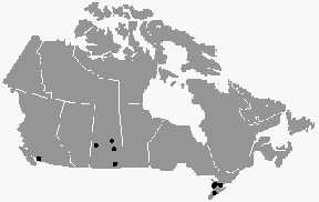
August 23, 2003 Vancouver, British Columbia, Canada – Even though the crop formation season has ended in England because most fields have been harvested, it has been evolving in Canada since July. At least fourteen crop formations have been reported in provinces ranging from British Columbia to Saskatchewan and Ontario – some eerily similar to the British pictograms of the early 1990s.
Click for report.
Field Notes from Wiltshire, England Crop Circles
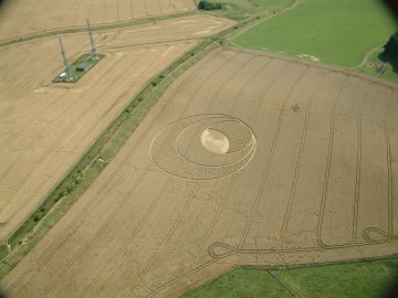
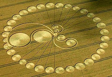
August 11, 2003 North Down, Wiltshire, England – Yesterday, a new 750-foot-diameter formation in wheat was reported between Morgan’s Hill and Cherhill Down directly east of the four tumuli and 11-concentric-ring formation of July 6, 2003 in North Down. From the air, the pattern contained 61 circles that alternate dark and light – the light being flattened crop and the dark standing. The circles create a 3-dimensional object that has three branches that resemble a hexagonal-structured molecule.

Field Notes from Morgan’s Hill Crop Circle
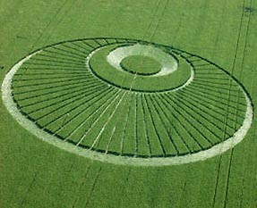
August 5, 2003 Devizes, Wiltshire, England – On Sunday afternoon, August 3, 2003, a new formation was reported at Morgan’s Hill on the other side of the North Down where the four tumuli and 11-concentric-ring formation was discovered on July 6, 2003. The next morning, Monday, I traveled to the formation and was impressed with the springy feeling the crop had under my feet. There, I met up with photographer and video producer, Bert Janssen, who has studied the geometry of crop formations for several years. He has produced two award-winning documentaries, Contact and Crop Circles: The Research. I explained to him that I had counted twenty-eight rays coming off one side of the large central flattened circle and seventy-eight coming off the opposite side. He walked around the top rays and into the large central circle trying to see if the rays lined up with the center “fountain” of wheat. They did not and the formation’s geometric structure became a challenge to understand.
Field Notes from English Crop Circles
July 31, 2003 Devizes, Wiltshire, England – I arrived in Wiltshire early Tuesday morning, July 29, 2003, after the Glastonbury Symposium and went directly to Woodborough Hill in Alton Barnes. The East Field, beneath Adam’s Grave and Knap Hill, is famous for receiving crop circles over the past decade and was still untouched by patterns. So was the spring barley across the road extending up to the base of Woodborough Hill. I could hear a helicopter, then another, which began circling over Woodborough and then on to the East Field, moved on to West Stowell and back around again. The helicopters were hovering, then lowering down toward the fields and then rising back up again. I had seen these same maneuvers back in August 2000 during one day that seven of us did a night watch at the East Field and watched through a night vision scope as an oval-shaped light jumped from side to side and changed shape into a bright square. (See Earthfiles August 2000.)Click for report.
Strange Orange Lightning and A Sampling of Recent English Crop Formations
July 21, 2003 – A sampling of recent formations in Wiltshire and Hampshire counties of southern England where so far, there have been forty-five formations reported in 2003. And an eyewitness report below about strange orange lightning seen from Knap Hill the night before a formation was reported at Windmill Hill on June 22, 2003.
Hackpen Hill, Wiltshire – Reported July 20, 2003
Update – Defiance, Missouri T-Pattern Cut in Saplings
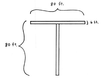
July 18, 2003 Defiance, Missouri Unusual patterns in cereal crops around the world have provoked some people to wonder if the formations are a warning that the Earth’s environment and food supplies are not guaranteed and in fact, might be seriously threatened. The past ten years on Dreamland radio and now Dreamland Online, I have interviewed dozens of scientists about problems in the air, land and sea, including increasing extinctions of plant and animal life. Now comes a new study reported in the journal Science which shows that in only thirty years, the amount of coral reefs in the Caribbean have declined 80% from what they once were.Click for report.
Land Surveyor Comments About Ogbourne St. George, U.K. Crop Formation
July 17, 2003 Howell, New Jersey After the Ogbourne St. George formation was discovered in Wiltshire, England, on Sunday, June 15, photographer and researcher Lucy Pringle wondered if it could be an 8-fold geometry instead of 6-fold? The reason is the “butterfly wing” distribution of the six arms, rather than an equally spaced distribution of the arms or spokes around the central circle. I was curious and asked professional land surveyor, Vincent Creevy, of Howell, New Jersey, to look at Lucy’s aerial photographs.Click for report.
Unusual Details in Dutch Crop Formations
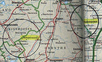
July 16, 2003 Wilhelminaoord, Drenthe, Holland – Yesterday Dutch crop circle researcher, Robert Boerman, who produces the website, www.dcca.nl, received a phone call about two crop circles in the same wheat field near Wilhelminaoord, Drenthe, Holland. The farmer is 60 years old and told Robert he had been working his fields for about forty years. He said he had never seen such patterns in his crops before and he was very happy that circles had finally come in his field. “That’s a different reaction than we are used to receiving from farmers!” Robert told me. Usually farmers are frustrated and angry.Click for report.