
Is Earth Close to Dangerous Tipping Point in Global Warming?

“It’s not really so much of a question whether the dangerous tipping point occurs at 450 or 550 ppmv CO2. It’s how do we get the (greenhouse) emissions under control so we don’t push past all the possible points at which the climate change becomes a seriously dangerous issue.”

- Chris Field, Ph.D., Director, Carnegie Institution's Dept. of Global Ecology, Stanford University, Palo Alto, Calif.

Almost 98% of the Antarctica South Pole continent is covered by ice, which averages a mile thick. Antarctica lost much more ice to the sea than it gained from snowfall, according to a NASA survey done between 1992 and 2002. It also had a corresponding rise in sea level.  The survey documented for the first time extensive thinning of the West Antarctic ice shelves. Credit: NASA/SVSSatellite image courtesy NASA.

June 1, 2007  New York, New York - The United Nations Intergovernmental Panel on Climate Change reported this year that there is at least a 90% certainty that global warming is man-made and will “continue for centuries.” The IPCC also reports that in coming decades, rising temperatures and rising sea levels will cause floods and mass famine. The implication is that there will be massive dislocations of humans and animals that have traditionally lived near coastlines. Despite the hard data, the George Bush Administration has resisted setting CO2 reduction goals, claiming there would be too many economic hardships for Americans. Ironically, it is the United States, which dominates the world list of greatest CO2 emitters.
 

Click here to subscribe and get instant access to read this report.

Click here to check your existing subscription status.

Existing members, login below:

Part 1 – U. S. Crop Formations Near Indian and Ancient Earth Mounds

May 30, 2007  Albuquerque, New Mexico - Here begins an overview of five American crop formations, all in the month of May 2007. Each one is near Native American and ancient earth mounds reminiscent of the closeness that Wiltshire, England, crop formations also have to ancient stone circles and earth mounds.

May 27, 2007 - Asheville, North Carolina

Home of Cherokee Indians; many earth mounds west of Asheville. More upcoming in Part 4.

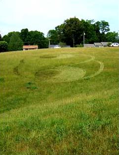
Asheville, North Carolina, resident Danny Tetrault sent in these photos of what he described as a crop circle he saw in West Asheville on Sunday, May 27, 2007. The grass formation can be seen off of North Bear Creek Road. Image © 2007 by Asheville Citizen-Times.
May 21, 2007 - Mission, Kansas (Suburb of Kansas City, Kansas)


Click here to subscribe and get instant access to read this report.

Click here to check your existing subscription status.

Existing members, login below:

Birmingham-Type “Drone” Seen At Barksdale AFB, Louisiana, in Mid-1980s


Click here to subscribe and get instant access to read this report.

Click here to check your existing subscription status.

Existing members, login below:

Deadly VHS Fish Virus Has Spread to Lake Michigan

Hemorrhaging (bleeding) in the fins and eye of a freshwater drum believed to be infected with the VHS virus.The fish was collected from Little Lake Butte des Morts. Image courtesy Wisconsin Department of Natural Resources.
Updated map: Lake Winnebago in eastern Wisconsin at Oshkosh, Lake Michigan, Lake St. Clair at Warren, Lake Erie and Lake Ontario (all highlighted with red in above map) have had metric tons of fresh water fish die from lethal viral hemorrhagic septicemia in 2005 through 2006; first die-offs of 2007 have now been reported to USGS. Authorities are trying to keep the virus from spreading to the other Great Lakes and into the Mississippi River (red underlined lower left) that extends south to New Orleans.

May 29, 2007  Madison, Wisconsin - The Wisconsin Department of Natural Resources reported on May 24, 2007, that a brown trout that died in Lake Michigan and washed ashore near the Kewaunee/ Algoma area preliminarily tested positive for viral hemorrhagic septicemia, or VHS. The University of Wisconsin-Madison Wisconsin Veterinary Diagnostic Laboratory conducted the preliminary test on the Lake Michigan trout. The sample has been sent to an Ames, Iowa, lab to confirm the VHS findings.The deadly fish disease also spread earlier this month to Lake Winnebago fish in eastern Wisconsin.


Click here to subscribe and get instant access to read this report.

Click here to check your existing subscription status.

Existing members, login below:

Two More Eyewitnesses of Aerial “Drones” in 2005 and 2006

“I’m told it’s some kind of communications device. It’s supposed to help the Park Service to monitor any possible problems like fires and such.”

- Sequoia National Park Ranger in Uniform, May 2005

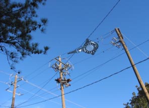
Odd, aerial object above power poles near construction site in May 2006, in Birmingham, Alabama. Photo by Mr. Smith.

Click for Earthfiles Podcast.


Return to:  Birmingham-Type "Drone" Seen At Barksdale AFB, La., in Mid-1980s.

Return to:  Previous Odd Aerial "Drone?" Earthfiles.

Return to:  Engineer Comments About Odd Aerial "Drone?" Earthfiles.

Return to:  Odd Aerial "Drone"? Photographed Again Over Capitola, California.

Return to:  Letters About Unidentified "Drone" Aerial Objects.


May 25, 2007  Sequoia National Park, California, and Birmingham, Alabama - As the intensity has risen this week to explain away the Lake Tahoe, Capitola and Central California Chad images as Photoshop and/or "viral promotional films," I have interviewed a California resident who worked for the state government in the Department of Developmental Services in mental health for twenty-five years before recently retiring in 2006. Shirley was born in Ventura County, California, and earned her Psychiatric Technician degree from Ventura Community College in 1978. I have her full address, contact information and academic background, but she has applied to work in another state agency, so has asked to simply be identified as Shirley from the Central Valley of California. She does not want the chaos surrounding the images to affect her new employment. But she wanted the public to know that the Chad photos match a dragonfly-like aerial object she saw two years ago.


Click here to subscribe and get instant access to read this report.

Click here to check your existing subscription status.

Existing members, login below:

Update: Part 1, Unusual Animal Deaths

"I investigated one strange animal death in Rio Hondo, New Mexico, where they found a mutilated bull underneath a trailer, which was amazing! ...It was just a blatant display of power and technology."

- Robert Allen, Gallup, New Mexico

May 25, 2007  Albuquerque, New Mexico - Since at least the 1960s to date, with a major peak in the 1970s, there have been so many cattle mutilations in the United States that sheriffs in Colorado, for example, were traveling to three mutilated carcasses a day still warm to touch. The mutilation phenomenon continues, but its geographic focus changes. Beginning in 2002, there has been a wave of animal mutilations in Argentina. Authorities estimate that more than three thousand cases have been reported to SENASA (Argentina's Dept. of Agriculture), veterinarians, police and other authorities.


Click here to subscribe and get instant access to read this report.

Click here to check your existing subscription status.

Existing members, login below:

Updated: Part 2 – New “Chupacabras” Attacks in Chile and Cattle Mutilations in Argentina

"The chupacabras entity with glowing eyes was hovering off the ground after it jumped off the roof. It seemed to be hovering a number of centimeters off the ground."

- Scott Corrales, Editor Explicata

Return to:  Part 1, Unusual Animal Deaths

Update June 1, 2007  Vina Del Mar, Chile -  Prof. Ana Luisa Cid in Mexico City, Mexico, provided the following recent chupacabras news report from Chile, translated by Scott Corrales © 2007, Institute of Hispanic Ufology, and Editor, Inexplicata.

"SOURCE: La Estrella (newspaper) DATE : June 1, 2007

CHILE: TERRIFYING CHUPACABRAS ATTACK IN VINA DEL MAR

Creature appeared in the Recreo Sector by Carla Olivares

Margarita Ugalde's family underwent an experience worthy of a horror movie in the early hours of Thursday morning in the Recreo sector of Vina del Mar after having a face-to-face encounter with the legendary and feared Chupacabras.


Click here to subscribe and get instant access to read this report.

Click here to check your existing subscription status.

Existing members, login below:

Updated: Odd Aerial “Drone”? Photographed Again Over Capitola, California

"No one had any idea what this thing was, but everyone in the car was visibly freaked out by it."

- rajman1977, Capitola

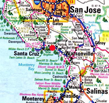
Capitola, population 10,033, is in Santa Cruz County northeast of Santa Cruz, California.

Return to:  Previous Odd Aerial "Drone?" Earthfiles

Return to:  Engineer Comments About Odd Aerial "Drone?" Earthfiles

[ Editor's Note: The words "Chad" and "Drone" at the beginning of my image file names are only an organizational effort for Earthfiles. I work on a Mac G-5 and re-size images for Earthfiles formats. I downloaded the Chad images from the COAST website, which I understand were also re-sized there. So, the only May 6, 2007, original images would be with Chad. Same applies to the May 5, 2007, Lake Tahoe Submitter 7013; and May 16, 2007, Capitola rajman1977 images.

Further, the two individuals quoted in 05/16/07Earthfiles Engineer Comments provided me names and contact information and are not anonymous to me, but I protected their confidentiality.

As a journalist, I would like to learn if our military has some kind of black project for ion electrostatic propulsion drones. ]

May 21, 2007  Capitola, California - Around May 11, 2007, Coast to Coast AM webmaster, Lex, received an email letter with attached May 6, 2007, images of a very odd aerial object from a Central California resident who calls himself "Chad." Chad is worried about his family's safety and health since he has now seen the bizarre aerial object at least eight times from his house windows and on hikes near his home. Neighbors, he said, have also seen the unidentified aerial object. Then on May 15, 2007, I received another similar aerial "drone" image allegedly taken by a person at Lake Tahoe, California, on May 5, 2007 and identifying themselves at UFO Casebook.com as "Lake Tahoe-05-05-07MUFON Submitter 7013."


Click here to subscribe and get instant access to read this report.

Click here to check your existing subscription status.

Existing members, login below:

EARTHFILES