"Attorney Danny Sheehan said that in one of two studies that were written at the Library of Congress for reading by President Jimmy Carter, the reports stated there are at least six extraterrestrial races from this galaxy visiting our planet. This was in one of the two official studies by the Library of Congress for the President of the United States."
- Grant Cameron, Director, www.presidentialufo.com
James Earl Carter, Jr., 39th President of the United States, 1977 to 1981.
Click here to subscribe and get instant access to read this report.
Click here to check your existing subscription status.
President Ronald Reagan on left, wife Nancy, and on right, E.T. film director, Steven Spielberg, at White House screening in 1982. Photograph from Ronald Reagan Presidential Library, Simi Valley, California.
October 28, 2003 - Winnipeg, Manitoba, Canada - Moments after the photograph above was taken in late June 1982, Steven Spielberg screened E.T.:The Extraterrestrial for President Ronald Reagan and First Lady, Nancy Reagan. Near the end of the movie, Reagan allegedly leaned over to Spielberg and stated, "You know, I bet there aren't six people in this room who know just how true this really is." (Source: Reagan Library)
Click here to subscribe and get instant access to read this report.
Click here to check your existing subscription status.
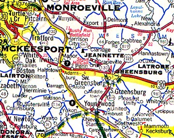
October 25, 2003 Greensburg, Pennsylvania - In 2002, former President Bill Clinton's Chief of Staff, John Podesta, joined the Sci-Fi Channel in a request to the Bush administration to release all documents it has on the Kecksburg, Pennsylvania "UFO crash" of December 9, 1965.
Click here to subscribe and get instant access to read this report.
Click here to check your existing subscription status.
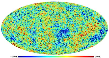
The Wilkinson Microwave Anisotropy Probe's first detailed map of the oldest light in the universe. Cosmologists call it a "baby picture" of the universe. Colors indicate "warmer" (red) and "cooler" (blue) spots. The oval shape is a projection to display the whole sky; similar to the way the globe of the earth can be projected as an oval. The microwave light captured in this picture is from 379,000 years after the Big Bang, over 13 billion years ago. Source: WMAP NASA.
October 24, 2003 Philadelphia, Pennsylvania - 2003 is turning out to be a pivotal year for cosmologists. In February, NASA's Wilkinson Microwave Anisotropy (an-EYE-stro-pea) Probe - known as WMAP - made precise measurements of the oldest light in the universe, the microwave background radiation from the Big Bang. The map produced from the microwave data breaks our universe down this way:
Click here to subscribe and get instant access to read this report.
Click here to check your existing subscription status.
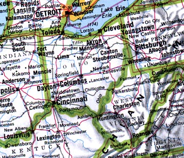
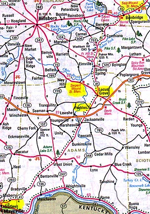
Ohio in 2003 has had UFO reports from Hamilton in the south to Akron and Canton in the north and the Columbus region, including Gahanna. Crop formations were found in the Chillicothe region of large, ancient earthworks such as the Serpent and Seip Mounds.
October 17, 2003 Florence, Kentucky - Since August 2003, many Ohio residents have seen large, strange, unidentified objects in the sky. Many of those reports have reached Kenny Young, an award-winning TV producer-writer-director who works full time as InfoChannel Coordinator for the Telecommunications Board of Northern Kentucky in Florence, Kentucky. In his off-hours, out of personal curiosity, Kenny produces and reports the UFO Research website, http://home.fuse.net/ufo.
Click here to subscribe and get instant access to read this report.
Click here to check your existing subscription status.
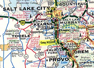
At 10:50 a.m. on October 16, 2003, a Utah National Guard NCO reported an “aircraft in distress” falling in the sky above Camp Williams south of Salt Lake City.
October 17, 2003 Salt Lake City, Utah –On Thursday, October 16, 2003, at 10:50 a.m. MT, a Utah National Guard NCO with several years in military service reported a “plane in distress” falling in the sky over Camp Williams south of Salt Lake City. As a precaution and in standard operating procedure in the event of a pending air crash, the Salt Lake City International Airport stopped two airliners from landing. But the FAA said there weren’t any aircraft in the area. When the NCO’s report reached higher authorities, NORAD at Cheyenne Mountain, Colorado, became involved. As of this date, NORAD has not released any official statement about the NCO’s report. The unofficial guess is that the object was “probably a meteorite.”Click for report.
"An analysis of astronomical data suggests not onlythat the universe is finite, but also that it has a specific, rather rigid topology (dodecahedral sphere). If confirmed, this is a major discovery about the nature of the universe."
George F. R. Ellis, "The Shape of the Universe," Nature,
Vol. 425, October 9, 2003, www.nature.com/nature
Click here to subscribe and get instant access to read this report.
Click here to check your existing subscription status.
Aberdeen, Ohio, is thirty miles southwest of the ancient Serpent Mound earthworks.
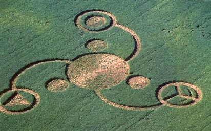
October 10, 2003 Aberdeen, Ohio - Since August, I have reported about two extraordinary crop formations of unknown origin in Ohio soybeans. The first was near the ancient earthworks known as the Serpent Mound between Locust Grove and Peebles, Ohio. The second was on Paint Creek island near the ancient Seip Mound in Bainbridge, Ohio, about 30 miles north of the Serpent Mound. Paint Creek was reported September 28 by a local newspaper after a pilot flew over it. The exact date of its creation is not known, but investigators think it was probably created the same time as the Serpent Mound pattern first discovered on August 24, 2003.
Click here to subscribe and get instant access to read this report.
Click here to check your existing subscription status.
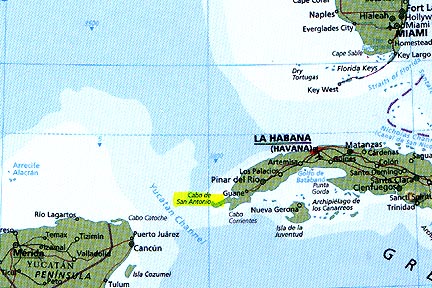
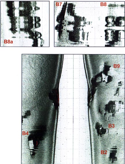
October 5, 2003 Havana, Cuba - Three years ago when Paulina Zelitsky and Paul Weinzweig, co-owners of Advanced Digital Communications, saw the first side scan sonar images of the deep water structures off the western tip of Cuba, some underwater objects were dark as metals sometimes show up on magnetometers. I asked Paul if any more data supported the initial cesium magnetometer data which implied there might be metal coatings on some of the megalithic structures.
Click here to subscribe and get instant access to read this report.
Click here to check your existing subscription status.
October 5, 2003 Bainbridge, Ohio - The following photographs were taken by Jeffrey Wilson during his field investigation of the Paint Creek Island, Ross County, Ohio, formation in soybeans on September 28, 2003. The formation is four miles west of the ancient Seip Mound and about thirty miles from the Serpent Mound. This is the third formation at the mounds in 2003.