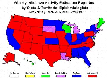
Part 1 – Why Do Military Helicopters Focus On Crop Formations?

August 29, 2003  Philadelphia, Pennsylvania – I arrived in Wiltshire, England early Tuesday morning, July 29, 2003, after speaking at the Glastonbury Symposium and went directly to Woodborough Hill in Alton Barnes. No one knew where I was and I had no set itinerary. I could see and hear helicopters circling over Woodborough and then on to the East Field, on to West Stowell and back around again. The helicopters were hovering, then lowering down toward the fields and then rising back up again. I had seen these same maneuvers back in August 2000 during one day that seven of us did a night watch at the East Field and watched through a night vision scope as an oval-shaped light jumped from side to side and changed shape into a bright square.Click for report.

Part 2 – After August 10, No Crop Formations Except in Canada?

August 29, 2003  Philadelphia, Pennsylvania – As I had reported on Coast to Coast AM and Dreamland Online back in June, after the crop formation appeared in Belgium on June 24, 2003 that was very similar to the Gog Magog Hills “angel” formation of July 25, 2001, that came 49 days before the September 11th Al Qaeda attacks on the United States, many wondered if the 2003 Belgium pattern meant that 49 days later on August 11, 2003, something else serious might happen – either in the crop formations or a world event.

Above, crop formation reported June 24, 2003, in Mielen-Boven-Aalst (Gingelom), Belgium. Very similar to the Gog Magog Hills "angel" formation below discovered July 25, 2001, southeast of Cambridge, Cambridgeshire, England. "Disturbing humming sound" was reported by people living near the field in Belgium.
Above, crop formation reported June 24, 2003, in Mielen-Boven-Aalst (Gingelom), Belgium. Very similar to the Gog Magog Hills “angel” formation below discovered July 25, 2001, southeast of Cambridge, Cambridgeshire, England. “Disturbing humming sound” was reported by people living near the field in Belgium.

Click for report.

No Ancient Oceans On Mars? Only Glaciers?

"Mars has probably always been very cold and if (occasional melted) water rushed out of those massive outflow channels and flowed out onto the northern plain, it likely froze very quickly."

­ Philip Christensen, Ph.D., Planetary Geologist, Arizona State University

Hubble Telescope image of Mars and the largest canyon in the solar system, Valles Marineris, that stretches for 2,500 miles (4,000 km).

August 27, 2003 Tempe, Arizona - Observations of Mars go back to the 1700s. People saw bright and dark markings on Mars and they speculated that the dark areas were oceans and the bright regions were continents. So, the idea of oceans on Mars has been postulated for three hundred years.


Click here to subscribe and get instant access to read this report.

Click here to check your existing subscription status.

Existing members, login below:

Mars At Its Closest August 27, 2003, At 2:51 a.m. PDT / 5:51 a.m. EDT.

Mars At Its Closest August 27, 2003,
At 2:51 a.m. PDT / 5:51 a.m. EDT.

Mars image by Hubble Telescope.

This week, Mars rises at 6:30 p.m. PDT / 9:30 p.m. EDT in the southeastern sky as it approaches what is known as "Mars opposition." Like a full moon, the red planet will be facing the Earth (opposition) and opposite the Sun on August 28, 2003. Mars will have reached its closest approach to the Earth in 60,000 years the day before on August 27 - only 34,650,000 miles away.


Click here to subscribe and get instant access to read this report.

Click here to check your existing subscription status.

Existing members, login below:

Fourteen Crop Formations in Canada


 Fourteen formations have been reported in Canada since July 23, spanning from British Columbia to Saskatchewan and Ontario provinces. Map © 2003 by Paul Anderson, CCCRN.
Fourteen formations have been reported in Canada since July 23, spanning from British Columbia to Saskatchewan and Ontario provinces. Map © 2003 by Paul Anderson, CCCRN.

August 23, 2003 Vancouver, British Columbia, Canada – Even though the crop formation season has ended in England because most fields have been harvested, it has been evolving in Canada since July. At least fourteen crop formations have been reported in provinces ranging from British Columbia to Saskatchewan and Ontario – some eerily similar to the British pictograms of the early 1990s.
Click for report.

Avebury Disk Was $85,000 “Balloon,” Says Britain’s Daily Mirror

In the August 23, 2003 edition of Britain's The Daily Mirror, reporter Nick Webster says the aerial disk that rotated and wobbled over Avebury on Saturday evening, August 16, 2003, was a 25-foot-diameter "space craft" that cost $85,000 (50,000 pounds) and was built by a TV firm called Chrysalis for a Channel 4 documentary entitled, "How To Build A Spaceship."


Click here to subscribe and get instant access to read this report.

Click here to check your existing subscription status.

Existing members, login below:

Avebury Eyewitnesses Follow Aerial Disk to Field East of Cherhill

Two eyewitnesses from the Red Lion Pub on Saturday, August 16, 2003, followed the rotating, wobbling disk to a harvested field of crop stubble East of Cherhill Down and the Gallops.
Four enhanced images from the videotape shot by Simon Beard on Saturday evening, August 16, 2003, from Avebury stone circles of the slowly rotating, wobbling aerial disk. See Earthfiles August 20, 2003. Composite by Andreas Mueller, www.invisiblecircle.de.


August 21, 2003 - Avebury, Wiltshire, England - This morning I talked with reporters, Lewis Cowen and Tamash Lal, respectively at the Wiltshire Gazette & Herald in Devizes and Evening Advertiser in Swindon, about the multiple eyewitness sighting of a black and white rotating disk over the Avebury stone circle on Saturday evening, August 16, 2003, after 9 p.m., near dark. The reporters concluded in their stories that the object was a "prank," either a camouflaged microlight or remote-controlled model, but neither has any substantive proof. I also talked with eyewitness, John Pearce, resident of Winterbourne Monkton, who is quoted in the articles, but his version is different than the media's.


Click here to subscribe and get instant access to read this report.

Click here to check your existing subscription status.

Existing members, login below:

Rotating Disk Hovered Over Avebury Stone Circles August 16, 2003


Avebury stone circle, largest in Europe, estimated to be more than 4,000 years old. Thirty witnesses at the Red Lion Pub in Avebury, Wiltshire, England, reported a rotating disk hovered about 200 feet above the center of the Avebury stone circle at twilight around 9:45 p.m. on Saturday evening, August 16, 2003. Aerial photograph © 2003 by Bert Janssen.

August 20, 2003 - Avebury, Wiltshire, England - Twilight was shifting to darkness at the Red Lion Pub in Avebury when people walking inside the big stone circle began to yell and point toward the sky. About thirty witnesses sitting outside the pub looked toward the shouts. A black and white disk-shaped object was slowly rotating about 200 feet above the center of the Avebury stone circle.


Click here to subscribe and get instant access to read this report.

Click here to check your existing subscription status.

Existing members, login below:

Field Notes from Wiltshire, England Crop Circles

August 11, 2003   North Down, Wiltshire, England –  Yesterday, a new 750-foot-diameter formation in wheat was reported between Morgan’s Hill and Cherhill Down directly east of the four tumuli and 11-concentric-ring formation of July 6, 2003 in North Down.  From the air, the pattern contained 61 circles that alternate dark and light – the light being flattened crop and the dark standing. The circles create a 3-dimensional object that has three branches that resemble a hexagonal-structured molecule.

Large “molecule” formation reported August 10, 2003, spanning approximately 750 feet in a wheat field directly east of the July 6, 2003, 11-concentric-ring formation. Aerial photograph © 2003 by Mark Fussell, cropcircleconnector.

Click for report.

Field Notes from Morgan’s Hill Crop Circle

August 5, 2003   Devizes, Wiltshire, England –  On Sunday afternoon, August 3, 2003, a new formation was reported at Morgan’s Hill on the other side of the North Down where the four tumuli and 11-concentric-ring formation was discovered on July 6, 2003.  The next morning, Monday, I traveled to the formation and was impressed with the springy feeling the crop had under my feet. There, I met up with photographer and video producer, Bert Janssen, who has studied the geometry of crop formations for several years. He has produced two award-winning documentaries, Contact and Crop Circles: The Research. I explained to him that I had counted twenty-eight rays coming off one side of the large central flattened circle and seventy-eight coming off the opposite side. He walked around the top rays and into the large central circle trying to see if the rays lined up with the center “fountain” of wheat. They did not and the formation’s geometric structure became a challenge to understand.

 Radio transmission towers atop Morgan’s Hill are south of the North Down formation. The crop formation at center lines up with the Morgan’s Hill stone marker whichis the dark spot in the middle of tramlines to the right of the formation. Aerial photograph © 2003 by Nick Nicholson.
Radio transmission towers atop Morgan’s Hill are south of the North Down formation. The crop formation at center lines up with the Morgan’s Hill stone marker which is the dark spot in the middle of tramlines to the right of the formation. Aerial photograph © 2003 by Nick Nicholson.

Click for report.