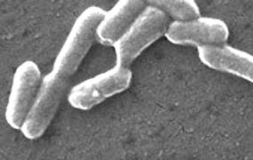
“There are many sources of water coming into the Salinas Valley watershed, and I guarantee you they all have generic E. coli.”
– Christopher Rose, California’s Central Coast Regional Water Quality Control Board


Reported and Edited by Linda Moulton Howe
“There are many sources of water coming into the Salinas Valley watershed, and I guarantee you they all have generic E. coli.”
– Christopher Rose, California’s Central Coast Regional Water Quality Control Board
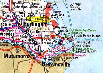
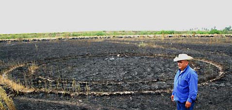
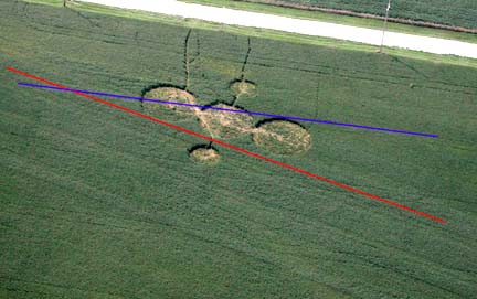
Updated September 20, 2006 (Originally filed September 14, 2006) Rio Hondo, Texas – Today I talked with reporter Allen Essex at the Valley Morning Star newspaper in Harlingen, Texas. Allen visited the site of the concentric rings with Star photographer, Joe Hermosa, earlier this week. There were three sets of rings all the same diameter “pressed down into the ground as if something very heavy had set down,” said Allen Essex. “All of the rings were pressed about five inches into the ground and at the bottom of the rings were crushed weeds. The rings in the photograph were the most distinct. The other two sets of rings were not quite as clear.”
I asked Joe Hermosa if he photographed all three sets of double rings and he said he did not because he would have to get too far away to get all three in the frame. He estimated that each pair of rings was separated from the others by about twenty to twenty-five feet. “But the three sets of rings were not in a straight line or in a triangle or anything like that,” said Essex. “It was just like something round and very heavy had set down three different times in the general area.”
“I thought about UFOs,” said Essex, “and I wanted to know if there was any radiation in the rings. So, I gathered some of the soil and took it to a hazardous waste material place. They tested the soil with a geiger counter, but it wasn’t much above background.”
Beatriz Huerta, Arnulfo’s wife, and their son, Marine Corps Lance Cpl. Armin Huerta (temporarily home from Iraq and now on travel again), noticed the three sets of concentric rings about 5:30 p.m., on Thursday, September 7, 2006. Arnulfo Huerta told Allen Essex, “We hadn’t noticed them before. You can see that the grass was too high to see them (before the burning).” Huerta said he got a burning permit from the Rio Hondo fire chief because the weeds were so full of ticks.
Allen Essex and Joe Hermosa from the Valley Morning Star measured the ring diameters. Essex reported that “the diameter of the most distinct set of round marks is 47 feet, 8 inches for the outside circle and 37 feet, 5 inches for the inner circle.” He told me that the other rings in the other two sets seemed to be the same size.
Essex talked to a Cameron County road crew working about two miles from the Huerta property, who said there were no signs of heavy vehicles or equipment anywhere around where the concentric rings were found.
Christmas Eve 2004 – A Bright Light Over Field
The Huertas told Essex that on Christmas Eve in December 2004, their son, Armin, saw a bright light right over the weed field where the concentric rings have now been discovered. Arnulfo told Essex, “My wife and I were at a birthday party and he (Armin) called us. He was real excited. There was a blue light, right out here where these circles are. Armin told us it lit up the whole inside of the house as if it were daytime.” The Huertas realized their son was nervous about the brightness of the light and he did not go outside to see the source. Now the Huertas wonder if the bright, blue light might have landed three times in the weeds two years ago for reasons unknown.
September 19, 2006 Email Update:
C. B. in Utica, Mississipi, emailed today: “In the mid-winter of the early 1970s, I was a teenager doing one of my farm chores of checking the perimeter fences on my father’s farm in Claiborne County, Mississippi. The farm is about fifteen miles south of Utica, Mississippi. We had cattle and my father wanted the perimeter fences checked daily. While heading back to the house on my horse, I found three perfectly flattened circles in the field a few hundred feet from our house.
“They were not concentric rings cut into the ground like those in the Rio Hondo, Texas, photograph on your Earthfiles webpage. The three depressions were perfectly round filled areas and about three feet apart. It was as if three extremely heavy perfectly flat round surfaces about 15 feet wide landed there and crushed the dried brush and grass till the pieces separated from the pressure. Or, maybe whatever it was landed, rose again, landed close by, rose again, and landed again close by. Whatever it was, it was quiet to have been so massively heavy.
“They were large and close together. I brought my father and mother to these large flattened areas to get their opinion. They didn’t know what to make of them. My father was a retired Marine drill instructor with military service during WW2 and a highly trained observer, but this really puzzled him. Had we burned the dried weeds away like this (Rio Hondo) rancher did, we might have even found rings like his.
“Whatever made those perfectly round flattened areas had to have weighed several tons or more to flatten out the tall, stiff brush so perfectly. I can drive my nearly two ton Ford pickup over the same kind of dried brush and can’t get it to flatten out the way that area was back then. That dried brush was completely crushed by something that came down on it from above. By that, I mean the stems of the dried dog fennel themselves were crushed and pulled apart. Whatever the craft was, it came straight down, too. The dried grasses weren’t twirled or twisted like crop circles I’ve heard about. And these three areas were not a deer bed or places where the cattle herd had lain in the night. The outer lines were too perfect. A cattle herd bunched up and sleeping on the ground like that would not have made depressions in the brush that perfectly round.
“Those rings had not been there the day before either. I would have seen them because I rode my horse a lot back then in the pasture behind the house checking on the cattle and perimeter fences.
“Back in August of 1979 I was twenty-one years old. I witnessed three UFOs come in from the east, west, and south and hover over this same farm. They looked like glowing balls of light. At first I thought they were helicopters because it was National Guard Weekend and helicopters flew over the farm all the time during National Guard Weekend. I estimate they hovered about a half a mile up for ten minutes. Then the UFOs quickly moved a 90 degree direction from their original flight path then suddenly shot off across the horizon at a 45 degree angle from the point they moved to. By example, I mean that the UFO from the west moved quickly south-west then zoomed north-east. How those three UFOs didn’t collide at those speeds is amazing. I just stood there with my mouth wide opened at what I had just witnessed. At those fantastic speeds, anything with a blood pulse would have died – or so I reasoned with my very very limited knowledge of space flight and UFOs.”
For further information about crop formations, please see reports below and going back to 1999 in the Earthfiles Archives and my book, Mysterious Lights and Crop Circles in the Earthfiles Shop:
Valley Morning Star: http://www.valleystar.com/articles/2006/09/11/local_news/7_saturday/local_news2.txt
English Crop Circles, Current and Archived: http://www.cropcircleconnector.com
American Crop Circles, ICCRA: http://www.cropcirclenews.com/
Canadian Crop Circles, CCCRN: http://www.cccrn.ca/
German Crop Circles: http://www.kornkreise-forschung.de
Dutch Crop Circles, DCCA: http://www.dcca.nl
http://www.lucypringle.co.uk
http://www.members.iinet.net.au/~bwratten/ccc.html
http://www.cropcircleresearch.com
http://www.CropCircleAnswers.com
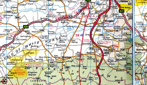
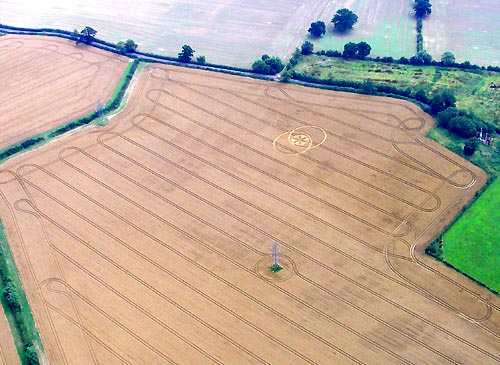
September 11, 2006 Santa Clara, California – Northwest of Oxford, Oxfordshire, England, is a farm region that includes March Baldon, Toot Baldon, Big Baldon, Little Baldon and Baldon on the Green. The entire region’s population is less than 500 people. Toot Baldon is located at the top of a hill and the name “Toot” means lookout. St Lawrence’s Church at Toot Baldon dates back at least to the 12th century and has wide views of the Thame valley to the Chiltern hills.Click for report.
Return to Part 1
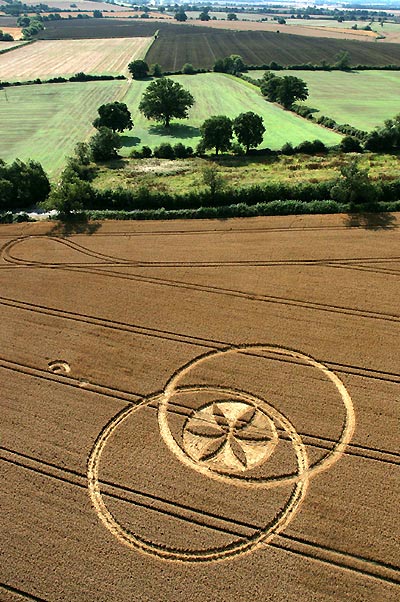
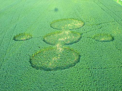
September 13, 2006 Albuquerque, New Mexico – After our frustrating trip to Toot Baldon near Garsington, Oxfordshire, on Thursday, August 3, 2006, most of us decided to drive back to Charlbury in Wiltshire southwest of Wayland’s Smithy to see the extraordinary “circles with wheat sculptures inside,” as some called it. The unusual formation was first reported on July 11.Click for report.
” I look at this new methane data as a disturbing early harbinger that maybe things might be worse than our global warming models predict.”
– Ken Caldeira, Ph.D., Carnegie Institution, Stanford University
September 9, 2006 Stanford, California – As we begin September 2006, there is more disturbing news about Earth’s environment. A rapidly spreading fungal disease is predicted to wipe out about half the world’s frogs, toads, newts and salamanders by the end of this year. Andrew Blaustein, a zoology professor at Oregon State University, says, “Species are going extinct very fast. These are bio indicators that something is wrong with the planet.”Click for report.
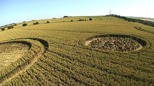
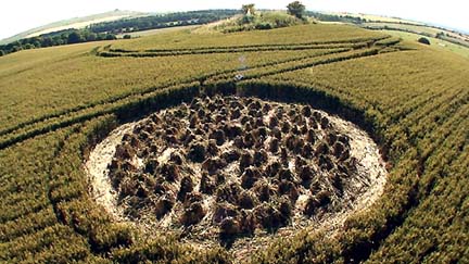
September 6, 2006 Geneseo, Illinois – On Thursday, August 24, 2006, Ted Robertson hired a fixed-wing airplane pilot to take him over the Jim and Chris Stahl soybean farm in Geneseo, Illinois. One of his photographs sparked a question in the minds of Roger Sugden and Jeffrey Wilson of the Independent Crop Circle Research Association (ICCRA).
August 31, 2006 Geneseo, Illinois – When I first learned about the Geneseo, Illinois, soybean formations on Monday, August 21, I immediately wanted to get aerials before the field deteriorated from visitor traffic and weather. So, I talked with the farm’s owner, Jim Stahl, who recommended Steve’s Nursery in Geneseo, which hires out for landscape photography. Later that afternoon, Mike Belovicks at Steve’s Nursery photographed for me the soybean circles from north, south, east and west. He also got a clear close-up of the southern circle which showed the downed soybeans there were still pretty fresh and green, without much feet damage from visitors. That contrasted with a close-up Mike was able to get of the far eastern circle where most visitors had entered on the original path made by farm owner, Jim Stahl on Saturday morning, August 19. In all five circles, the soybean plants were circling clockwise, with the exception of anomalies in the eastern and center circles discussed below.Click for report.

August 28, 2006 Geneseo, Illinois – On Friday, August 25, 2006, around 3 p.m. CDT, Jim Stahl heard and saw a large, dark helicopter circling over the soybean formation to the west of his house. He managed to grab a digital camera and and got outside as the helicopter flew over his yard and away to the north.Click for report.
August 27, 2006 Geneseo, Illinois – On Sunday, August 20, 2006, Quad City Times reporter, Barb Ickes, wrote: “The crop circles at Jim Stahl’s farm appeared as they always do – out of nowhere. … The five circles in his soybean field create a geometric pattern. Three of the circles are the same size – about 50 feet in diameter – and are connected like beans in a pod. The other two circles are half the size of the others and flank them on either side. They appear to be precisely the same distance from the main circle. …Amid a 90-acre field of soybeans, Stahl discovered the oddity Saturday morning (August 19, 2006). He called the Henry County Sheriff’s Department.”Click for report.
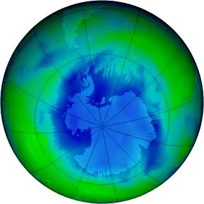

August 19, 2006 Geneva, Switzerland and Nairobi, Kenya – According to the United Nation’s World Meteorological Organization (WMO), ozone over the Antarctic will not recover to 1970 levels until 2065, fifteen years later than earlier predictions.Click for report.