Part 2: Anomalies Confirmed in Pennsylvania and Arizona Randomly Downed Crops

Tolleson, a Phoenix suburb, is region where Brooks Farms cereal crops are grown in big fields on Buckeye Road and Lower Buckeye Road.
Above and below: In late May 2005, three barley fields - including this one operated by Brooks Farms near intersection of 75th Avenue and Buckeye Road,Phoenix, Arizona, in the Tolleson suburb - had straight parallel lines of standing crop between which were randomly downed and standing crop. These May 25, 2005, aerial photographs © 2005 by KTVK, Channel 3 News.
Above and below: In late May 2005, three barley fields – including this one operated by Brooks Farms near intersection of 75th Avenue and Buckeye Road,Phoenix, Arizona, in the Tolleson suburb – had straight parallel lines of standing crop between which were randomly downed and standing crop. These May 25, 2005, aerial photographs © 2005 by KTVK, Channel 3 News.

Road side view looking down some of the straight berms and randomly downed and standing barley. May 24, 2005, photograph © 2005 by Scott Davis.
Road side view looking down some of the straight berms and randomly downed and standing barley. May 24, 2005, photograph © 2005 by Scott Davis. 
Foreground is single standing clump of wheat inside long, straight section of downed barley. May 24, 2005, photograph © 2005 by Scott Davis. 
Foreground is single standing clump of wheat inside long, straight section of downed barley. May 24, 2005, photograph © 2005 by Scott Davis.

Return to Part 1 

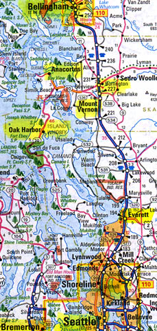
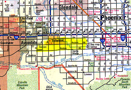
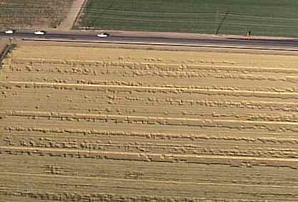
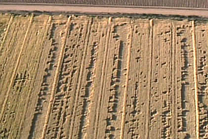
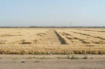
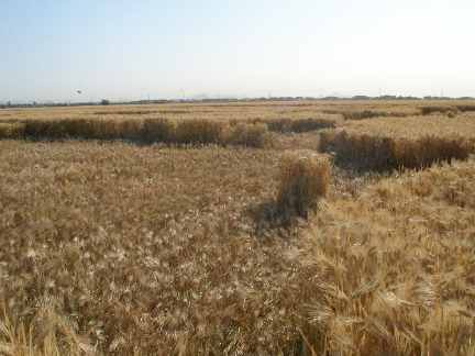
August 1, 2005 Grass Lake, Michigan – In the third week of May 2005, three long, parallel strips of wheat were reported by a Phoenix radio station to be laid down in a field near Lower Buckeye Road and 75th Avenue in the Tolleson suburb of Phoenix, Arizona. Jeffrey Wilson, Director of the Independent Crop Circle Researchers’ Association (ICCRA) in Ohio, asked Rod Bearcloud Berry to investigate which he did on May 19. Jeff e-mailed, “Bearcloud reports that there are three linear flattened pathways approximately 525 to 600 feet in length that are parallel to the power lines and the road. Interspersed between the three pathways are a series of irregular flattened shapes, none of which cross any tramlines.” [ See 052605 Earthfiles.Click for report.

Feedback on Half Cat Mystery

“The kitten’s corpse was pretty much as described in your broadcast: upper half only with skin down to about mid torso. The description of a child’s hand puppet is exactly what I was thinking when I saw it.”

– M. G., Houston, Texas

July 28, 2005  From Washington, California and Arizona to Texas and Tennessee – The following are a few of the many e-mails I have received from Earthfiles viewers and COAST listeners about the half cat phenomenon reported about in 071405 Earthfiles and other Earthfiles listed in More Information below. Click for report.

Updated – Mystery of Six Grass Circle Formations in North Carolina

Updated July 28, 2005, with new photographs below.

July 23, 2005 Williamsburg, Ohio – Beginning on June 13, 2005, a series of six circle patterns in North Carolina grasses began to emerge, all at elevations above 2,000 feet. American crop circle investigator, Jeffrey Wilson, told me this week: “We really have not seen crop circles in locations at this kind of elevation before, so I think this is notable.” Jeff is Director of the Independent Crop Circle Researchers’ Association (ICCRA) in Ohio. Other investigators included Delsey Knoechelman, Ted Robertson and Roger Sugden, and Mike and Jackie Price. Jeff has gathered over 500 reports related to crop formation events in the United States from 1880 to 2005. The majority of American crop formations have occurred east of the Mississippi River – and Ohio has had the most, at least 35 crop formations.Click for report.

H5N1 Bird Flu Virus Kills Three Indonesians

Jakarta, Indonesian burns dead chickens likely infected with H5N1 bird virus. Image © 2005 by AP/Irwin Fedriansyah.


July 22, 2005 Jakarta, Indonesia – The World Health Organization (WHO) confirmed this week: “The Ministry of Health in Indonesia reported that a 38-year-old father who died on 12 July was the country’s first laboratory-confirmed H5N1 positive human case of avian influenza. His two daughters also died of severe pneumonia illness compatible with H5N1 infection, but laboratory confirmation is not yet available. Limited samples were available from the 8-year-old daughter who died on 14 July, and the 1-year-old daughter who died on 9 July.”  Click for report.

Updated: 584 Degrees F. Hot Rock Mystery Northeast of Santa Barbara, California

“We took a geiger counter out and there were no abnormal readings anywhere on the landslide. So we did not pick up any indications there is any radioactivity. We have also asked U.S.G.S. to check the samples that are in there now being analyzed for any signs of radioactivity. So, we’re doing a double check on it. … It’s a very interesting and mysterious site that we’re really hoping we get some more definitive answers on. But so far it has been quite, quite mysterious.”

– Allen King, USDA Forest Service Geologist

Red X on map is east end of Dick Smith Wilderness in Los Padres National Forest where a fire started on August 21, 2004, due to high temperatures in 3-acre region of 17-acre landslide. Santa Barbara is about 18 miles southwest. Temperatures have remained high for eleven months.

July 22, 2005 Updated – In this unusually hot July, the National Interagency Fire Center based in Boise, Idaho, reports that right now there are active large fires in 11 states – Alaska, Arizona, California, Colorado, Idaho, Louisiana, Montana, Nevada, New Mexico, Oregon and Utah. Nearly 4 million acres (3.9 million) have burned so far this year.Click for report.

More Half Cat Mutilations in Seattle, Washington Region

Bellingham, Anacortes, Burlington, Mount Vernon, Oak Harbor, Everett, Bothell, Bremerton and Seattle, locations of past and present half cat mutilations in state of Washington.

July 14, 2005  Oak Harbor, Whidbey Island, Washington – In the third week of May 2002, four domestic cats were found in the Fairhaven district of Bellingham north of Seattle, slit from the throat to the pelvis. But there was no blood on the fur or the ground. Bellingham Police Lt. Dac Jamison said, “There is methodology to what’s going on.” The speculation was that the cats were some how removed from their home or neighborhood, taken somewhere for the cut and excision of internal organs, and returned close to their homes.Click for report.

8,000 White Pelican Chicks Mysteriously Died At Chase Lake, North Dakota

Typical scene of American White Pelican chicks at Chase Lake National Wildlife Refuge before the 8,000 chicks died over July 4th weekend. Photograph credit: Tom Pabian, U. S. Fish and Wildlife Service.
Chase Lake National Wildlife Refuge north of Medina, North Dakota, has been the home of nearly 30,000 American White Pelicans for the past two years. Then 29,000 disappeared in 2004. After the return of many of the adults in 2005, now at least 8,000 white pelican chicks have mysteriously died.
Chase Lake National Wildlife Refuge, North Dakota, north of Medina. Photo courtesy USFWS.


July 14, 2005  Medina and Bismarck, North Dakota – A year ago, beginning on May 24, 2004, the Bismarck, North Dakota office of the U. S. Fish and Wildlife Service began hearing that American White Pelicans were disappearing from the Chase Lake National Wildlife Refuge north of Medina, North Dakota. Over four days the end of May 2004, the estimated number of large water birds dropped from 27,000 down to 80 at two of three nesting sites. The third nesting site of pelicans remained normal with 2,400 birds – adding to the mystery about why? – and how? – could 27,000 pelicans disappear without a trace? By June 17, 2004, another 2,000 American White Pelican adults disappeared. The 29,000 missing pelicans left their eggs and chicks behind. The disappearance remained a mystery until this summer when about 18,000 adults returned to Chase Lake for nesting.Click for report.

U. K. Bicyclist Reports Mysterious, Low Hovering Objects Bending Wheat

“…I am certain that there is some other form of intelligence, either on this planet or visiting the crops from somewhere else. I have no doubt about that after seeing what I saw.”

– Mike Booth, Marlborough, U. K. Resident

Marlborough is northeast of Lockeridge in Wiltshire County, England.

  
July 1, 2005  Lockeridge, Wiltshire, England – Mike Booth has spent much of his forty-five years designing for race cars and planes. He received his British National Diploma in Art from Buckinghamshire’s Amersham School of Art and Design in 1979. In his spare time, he also writes songs and tries every other night to ride his mountain bike from his home near Marlborough out the road from Lockeridge, past Boreham Down and the West Woods on to Alton Barnes. The road goes right through the heart of Wiltshire’s crop circle country, but Mike had never seen anything especially unusual until 6:30 p.m. on Tuesday, June 21, 2005, as he was riding next to Boreham Down.Click for report.

EARTHFILES