Woman Witnessed 1996 Crop Circle Appearing Opposite Stonehenge

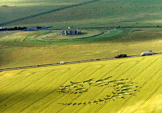
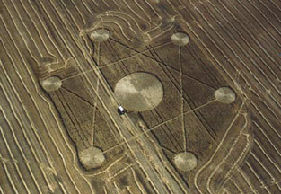
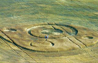
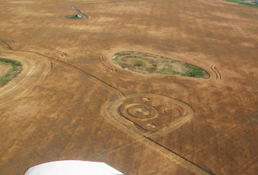
“There was an apparition, an isolated mist over it and as the circle was getting bigger, the mist was rising above the circle. As the mist rose, it got bigger and the wheat circle got bigger.”

- U. K. Eyewitness “M”

October 15, 2009  Petersfield, Hampshire, England - Recently, U. K. crop formation researcher and aerial photographer, Lucy Pringle, contacted me about her meeting a woman she calls “M,” who described watching the July 7, 1996, fractal Julia Set literally forming before her eyes during an estimated 20 minutes. [ Editor's Update:  Back in 1996, the formation was originally linked to July 8, 1996, as date of first report, followed by later off-the-record comments from a pilot that the formation occurred in a 45-minute window of time on Sunday, July 7, 1996, in the late afternoon, which is consistent with M's recall to Lucy Pringle below.]

The fractal Julia Set was first reported across the A303 highway from ancient Stonehenge on July 7, 1996. The formation measured 915.5 by 508 feet, covered a square acre and was made of 151 circles. The center of each circle twisted differently, according to field investigators. Aerials above and below © 1996 by Lucy Pringle.


Click here to subscribe and get instant access to read this report.

Click here to check your existing subscription status.

Existing members, login below:

More Lights Like Stephenville, Texas, in Maine

“A man who is career military here is absolutely perplexed by the photos.”

- Jonathan Spak, Fryeburg, Maine

October 12, 2009  Fryeburg, Maine - Jonathan Spak, 37-years-old, was born and raised in Washington, Connecticut. After high school, he attended the Culinary Institute of America and graduated with a degree in culinary arts. After apprenticeship with a French chef, he and his wife opened up their own restaurant and inn two years ago in Fryeburg, Maine, near the New Hampshire border.


Click here to subscribe and get instant access to read this report.

Click here to check your existing subscription status.

Existing members, login below:

Updated:  25% of Novel H1N1 Americans Sick Enough for Hospitalization End Up in Intensive Care

“Contrary to the perception among many people that this influenza, the novel H1N1, is mild, (new) data vividly demonstrate that this influenza can make you very, very ill.”

- William Schaffner, M. D., Vanderbilt University Flu Exper


New England Journal of Medicine on October 8, 2009, reports CDC research that indicates 7% mortality in U. S. H1N1 cases - above normal seasonal flu. H1N1 cases doubling each week and virulent strain of H3N2 coming north from Southern Hemisphere. Novel 2009 H1N1 photomicrograph by CDC.

    Click for podcast.

See:  October 8, 2009 Online Issue.

- Critical Care Services and 2009 H1N1 Influenza in Australia and New Zealand.

- Hospitalized Patients with 2009 H1N1 Influenza in the United States, April–June 2009

October 9, 2009  Houston, Texas - The October 8, 2009, New England Journal of Medicine featured two recent studies about the intensity of the new 2009 H1N1 flu virus, both in the United States and the Southern Hemisphere’s Australia and New Zealand.

Perhaps the most surprising news in the research by the American Centers for Disease Control is that this past spring, 7% of Americans sick enough to be hospitalized with the H1N1 flu, have died. That 7% is a higher mortality rate than ordinary seasonal flu.


Click here to subscribe and get instant access to read this report.

Click here to check your existing subscription status.

Existing members, login below:

Part 2 – 2009 Canadian Crop Formations: Stettler, Alberta and Moose Jaw, Saskatchewan

“I was amazed that I found entire stems coming from the ground flattened that were perfect without breaks, cracks or creases.”

- Donald Tash, M. S., Retired Science Teacher, Stettler, Alberta


Return to Part 1

October 5, 2009  Stettler, Alberta, Canada - The Cropcircleconnector.com lists 93 crop formations worldwide for 2009. The list includes: Belgium - 4;Czech Republic-1; United Kingdom-51; France-2;Germany-10;Italy-7;Netherlands-9; Norway-1;Poland-1; Russia-1;Slovakia-2; Switzerland-1;USA-1 (Wilbur, Lincoln County, Washington, July 23, 2009) and Canada-2.


Click here to subscribe and get instant access to read this report.

Click here to check your existing subscription status.

Existing members, login below:

Updated:  Connecticut Man Uses iPhone to Photograph 3 Discs Over Stamford

Update - October 1, 2009 email from Kersten S., born and raised in Germany, now working as videographer and limo driver based out of Norwalk, Connecticut, in response to very troubling and insidious iPhone camera news:  Gold and Silver iPhone versions now have new application to add UFOs to photographs.

From: Kersten S. Subject: UFO camera SILVER, application pour iPhone, iPhone 3GS et iPod Touch | App Store Date: October 1, 2009 To: [email protected]

“Linda, the picture was not done with a software, but it does look very similar to the samples people sended in.”

“Then I grabbed my iPhone, clicked once and got those three discs not moving.” - Kersten S., Limousine Driver, Stamford, CT

“Then I grabbed my iPhone, clicked once and got those three discs not moving.”

- Kersten S., Limousine Driver, Stamford, CT

Stamford, Connecticut, is on Long Island Sound northeast of New York City.

September 30, 2009  Stamford, Connecticut - Kersten S. from Norwalk, Connecticut, was working as a driver for a limousine company between 1 and 2 PM on Wednesday, September 30, 2009, in Stamford, Connecticut, northeast of New York City. He parked to complete paper work in the town car he was driving. His car faced east toward Long Island Sound.


Click here to subscribe and get instant access to read this report.

Click here to check your existing subscription status.

Existing members, login below:

Part 1 – 2009 Canadian Crop Formations: Wheat Circles in Stettler, Alberta, Canada

“The first thing we did was to see if any tracks went in and out, and I couldn’t see anything from atop the sprayer 16 feet off the ground.”

- Colby Squires, Stettler Crop Sprayer

Stettler, Alberta, Canada, is 62 miles east of Red Deer, location of a huge wheat hexagram formation discovered eight years ago on September 16, 2001.


Eight years ago on September 16, 2001, farmer Ken Bickford discovered a 422-foot-diameter hexagram in his Red Deer, Alberta, wheat field. The swath on the left was his first drive through on his combine. After that, Mr. Bickford drove around the formation to preserve it. A pilot said he flew over the wheat hexagram on September 2, 2001, but did not report it. Aerial photograph © 2001 by Lyle Ford, CCCRN. Also see:  092201 Earthfiles.
Discovered on August 25, 2009, at 7 PM MTN by Colby Squires while spraying a wheat field to dry it out before combining in Stettler, Alberta, Canada. The field is farmed by Gordon Smith, who decided to harvest around the wheat formation. September 9 aerial image © 2009 by Mustafa Eric, Stettler Independent.
Green, shallow, slough behind wheat formation. Aerial image © 2009 by Rob McNeill.
Diagram © 2009 by Paul Anderson, CCCRN.

September 26, 2009  Stettler, Alberta, Canada -  A month ago on August 25, 2009, at 7 PM MTN, Colby Squires was running his 100-foot-wide sprayer through the wheat field that Gordon Smith farms in Stettler, Alberta, Canada. Stettler is a small community of about 5,500 people who work on farms or in surveying and laying pipes for the oil and gas industry.


Click here to subscribe and get instant access to read this report.

Click here to check your existing subscription status.

Existing members, login below:

Yeti in Tatra Mountains, Poland?

“I saw this huge, ape-like form hiding behind the rocks. When I saw it, it was like being struck by a thunderbolt.”

- Piotr Kowalski, Warsaw, Poland, hiker


Tatra Mountains in southern Poland (red circle). Highest peak is Rysy at 2,499 meters (8,190 feet). Map above © by GraphicMaps.com. Photo of Tatra Mountains below © by Destination360.
Tatra Mountains in southern Poland (red circle). Highest peak is Rysy at 2,499 meters (8,190 feet). Map above © by GraphicMaps.com. Photo of Tatra Mountains below © by Destination360.

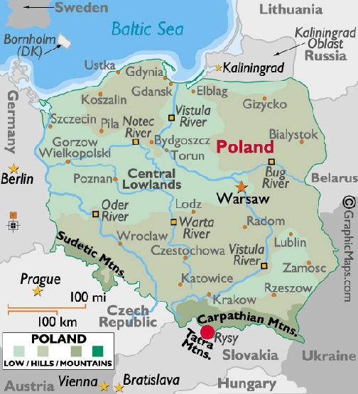
September 16, 2009  Tatra Mountains, Poland -  On Monday, September 14, 2009, the Austrian Times headlined: “Polish Yeti Caught On Film.”


Click here to subscribe and get instant access to read this report.

Click here to check your existing subscription status.

Existing members, login below:

More Aerial “Milk Bottles” Photographed By Game Trail Cameras

“These [ December 1, 2008] ‘milk bottle’ photographs, are unique because they show the object behind a tree branch. This finally settles the reflection/real object controversy; whatever it is, this new data clearly confirms it is a real object.”

- Chris Zietkiewicz, Ph.D., Senior Engineer

“Milk bottle” aerial object caught by game trail camera behind tree branch on December 1, 2008, between 11:05 PM and 11:29 PM Central in Edom, Texas. Image provided by camera owner.

September 11, 2009  Edom, Texas -  A year and a half ago on April 7, 2008, I interviewed Bob Coine, President and Owner of Heartland Studios, Inc., in Oregon, Illinois. His company is devoted to protecting, improving and managing wildlife, with an emphasis on white tail deer. See:  040708 Earthfiles.

In order to keep track of how many white-tailed bucks and does use his farm and to estimate ages of the bucks, Bob explained that he uses a variety of game trail cameras. He has pure infrared cameras that do not flash and take images in non-visible infrared; standard 35mm cameras; and digital cameras that have an infrared beam to detect motion, which then triggers the camera to flash in the visible light spectrum. Six photographs taken in visible flash mode on November 16, 2007, beginning at 3:59 AM over a three minute time span, are still a mystery.


Click here to subscribe and get instant access to read this report.

Click here to check your existing subscription status.

Existing members, login below:

Authorities Baffled in California and Switzerland As Cattle Fall Off Cliffs and Die

“We are investigating because cows that grow up in the mountains normally can estimate dangers and do not plunge down cliffs.”

- Swiss Police Officer

September 8, 2009  Coarsegold, California, and Lauterbrunnen, Switzerland -

Coarsegold, California

Coarsegold is a ranching region north of Fresno, Madera County, California.

On August 14, 2009, more than thirty young males from a cattle herd were discovered dead in the Fresno River near Coarsegold, California, in Madera County. The owner of the animals is a rancher from Chowchilla, California, who did not talk to the media.


Click here to subscribe and get instant access to read this report.

Click here to check your existing subscription status.

Existing members, login below:

EARTHFILES