Update on August 19, 2002 - The following is the Sunday, August 18, 2002 E-mail I received from Earthfiles viewer who described himself as: "A large part of my full time job is decoding ciphers and reverse enginereering communication protocols." His original text below is updated with additional notes about the bell ringing sound. (He requested anonymity and later gave his name as Richard Brain.)
Click here to subscribe and get instant access to read this report.
Click here to check your existing subscription status.
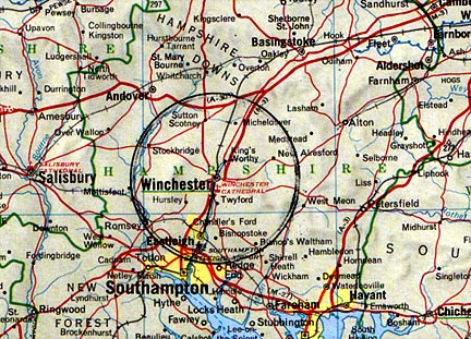
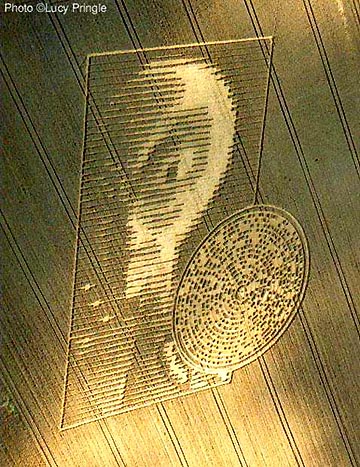
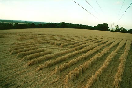
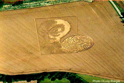
August 19, 2002 Pitt near Winchester, Hampshire, U. K. On Thursday afternoon, August 15, 2002, editors Mark Fussell and Stuart Dike at the website, www.cropcircleconnector.com, received an e-mail from a man who also e-mailed Lucy Pringle. The text said there was a "new crop circle near Winchester" and also gave street guidance to the farm location along the Crabwood copse in the village of Pitt near Winchester. The editors needed someone to fly over the formation which Julian Gibsone did on Friday morning, August 16. The editors also called Charles Mallett at The Silent Circle Cafe in Cherhill. Charles and his wife, Frances, operate the cafe and have investigated and photographed more than a hundred formations the past few years in southern England. The couple went to Winchester also on Friday morning to study and photograph the ground lay of what Charles perceived to be an "amazingly precise" pattern.
Click here to subscribe and get instant access to read this report.
Click here to check your existing subscription status.
September 12, 2002 - For the most up-to-date research on this evolving story, see Lucy Pringle's report at: http://lucypringle.co.uk/
EDITOR'S NOTE ABOUT TIME LINE OF EVENTS: Since the interviews below with Winchester farm owner, Mike Burge, and his farm hand, Sydney Collis, Charles Mallett in Cherhill, England confirms that www.cropcircleconnector.com was contacted by e-mail on Thursday, August 15, about the Winchester formation. Also contacted by e-mail that day (by the same person who mailed the connector) was researcher and photographer, Lucy Pringle in Hampshire. Mike Burge and Sydney Collis both were in the cherry picker above the field on Monday afternoon, August 12, and are adamant the wheat field was perfectly normal then. So, the possible creation period is Tuesday night, August 13, producing what seemed to be a partial formation according to farm worker, Sydney Collis, who found "marks in the wheat" at 8 a.m. on Wednesday morning, August 14. That leaves Wednesday night into Thursday as other possible creation times. The formation notification first went out by e-mail on Thursday, August 15, followed by an Ocean FM radio report on Friday morning, August 16, around 9 a.m..
August 17-18, 2002 Winchester, Hampshire, England - Crop formation researcher and photographer, Lucy Pringle, received an e-mail dated August 15, 2002 at 19:30 (7:30 p.m.) Hampshire time from a man who reported a "New Crop Circle Near Winchester" which Lucy did not download until midnight, working into the early hours of August 16. Lucy e-mailed a request for the Survey Ordnance and he replied with SU447297, which Lucy received in e-mail early Friday morning, August 16, and notified Paul Vigay, Director, Independent Research Center for Unexplained Phenomena.
Lucy booked an airplane to fly over the field at 2:30 p.m. She did not know that the Ocean FM station in Southampton, Hampshire, received a telephone call around 9 a.m. on Friday, August 16, 2002, from a woman who said she had been riding her horse by the Vale Farm in the village of Pitt east of Winchester when she saw a formation in the wheat field. The radio announced the discovery and farm owner, Mike Burge, heard about it from his farm hand, Syd Collis.
Click here to subscribe and get instant access to read this report.
Click here to check your existing subscription status.
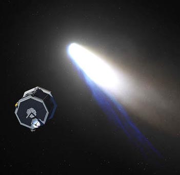
NASA artist's conception of Comet Nucleus Tour (CONTOUR) spacecraft approaching one of the comets it planned to study, including Comet Encke in 2003, Comet Schwassman-Wachmann 3 in 2006 and Comet d'Arrest in 2008.
NASA UPDATE ON AUGUST 26, 2002:
"On Aug. 15, CONTOUR's STAR 30 solid-propellant rocket motor
> was programmed to ignite at 4:49 a.m. EDT, giving CONTOUR
> enough boost to escape Earth's orbit. At that time, CONTOUR
> was about 140 miles above the Indian Ocean and out of radio
> contact with controllers. The CONTOUR mission operations team
> at APL expected to regain contact at approximately 5:35 a.m.
> EDT to confirm the burn, but NASA's Deep Space Network (DSN)
> antennas did not acquire a signal.
>
> Since then, there has been no contact with CONTOUR. Commands
> pre-programmed into the spacecraft's flight computer system,
> designed to instruct the spacecraft to try various alternate
> methods of contacting Earth when contact is lost, also have
> not worked to date.
>
> Images from a Spacewatch ground-based telescope at Kitt Peak,
> Ariz., show three objects at the location where CONTOUR was
> predicted to be, images which may indicate the spacecraft has
> broken apart. Mission controllers at APL will continue
> listening for signals from the spacecraft periodically until
> early December, when CONTOUR will come into a more favorable
> angle for receiving a signal from Earth."
August 16, 2002 Laurel, Maryland - Late this afternoon at Johns Hopkins University's Applied Physics Laboratory (JHUAPL), Dr. Robert Farquhar, Mission Director for the Comet Nucleus Tour (CONTOUR), teleconferenced with reporters about the status of the missing CONTOUR spacecraft. CONTOUR's STAR 30 solid-propellant rocket motor was programmed to ignite at 4:49 a.m. EDT yesterday, August 15, to launch the probe out of Earth orbit onto a trajectory to study two or three comets over the next few years. At that burn time, CONTOUR was over the Indian Ocean at 140 miles (225 kilometers), too low for NASA's Deep Space Network stations to track the spacecraft during the burn. All systems seemed to be OK going into the burn, but 45 minutes later when the JHUAPL mission operations team tried to regain contact with the probe, no signal was received.
Click here to subscribe and get instant access to read this report.
Click here to check your existing subscription status.
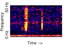
Spectrogram of an unidentified deep ocean sound, referred to as "Bloop." The bloop sound was repeatedly recorded during the summer of 1997 on the Equatorial Pacific Ocean autonomous hydrophone array. The sound rises rapidly in frequency over about one minute and was of sufficient amplitude to be heard on multiple sensors, at a range of over 5,000 km. It yields a general location near 50oS; 100oW (far off the west coast of southern South America). The origin of the sound is unknown. A recording of the bloop sound can be heard, sped up 16 times, at: http://oceanexplorer.noaa.gov/explorations/sound01/sound01.html
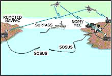
June 30, 2002 Woods Hole, Massachusetts - The June 13, 2002 issue of New Scientist featured an article by reporter John von Radowitz in London about an underwater sound deep in the ocean recorded in 1997 by NOAA scientists that remains unidentified. The "Bloop" was detected and recorded from an array of underwater hydrophones (microphones) originally set up by the U. S. Navy in the 1960s to track Soviet submarines. The listening technology is distributed in a deep ocean level known as the "sound layer" which marine animals such as whales and human technology such as submarines use for long-range communication.
The SOund SUrveillance System, or SOSUS, consists of bottom-mounted hydrophone arrays connected by undersea communication cables to facilities on shore. Illustration courtesy Naval Research Laboratory.
The "Bloop" was detected by hydrophones up to 4,800 kilometers apart (2,983 miles). That is a long distance for a single sound to be heard. Thus, speculation began about what the "Bloop" might be. The New Scientist article stated that the great distance it covered "meant it had to be much louder than any recognized animal noise, including that produced by the largest whales."
Recently, NOAA scientist Chris Fox who originally recorded the "Bloop," sent one recording to Dr. Phil Lobel, a marine biologist at the Woods Hole Laboratory in Massachusetts and a Professor of Marine Biology at Boston University. Dr. Lobel studies underwater sounds made by fish and other marine animals. I asked him what he thought the Bloop could be.
Click here to subscribe and get instant access to read this report.
Click here to check your existing subscription status.
"We are talking about a global disaster of apocalyptic dimensions
if an asteroid that size were to hit us."
Benny Peiser, Ph.D., Liverpool John Moores University, U. K.
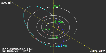
Asteroid 2002 NT7 currently tops the Impact Risk list of NASA/JPL's Near-Earth Object Program because current calculations place it crossing the earth's orbital path on or about February 1, 2019, or other possible later dates. NASA says, "While this prediction is of scientific interest, the probability of impact is not large enough to warrant public concern."
July 25, 2002 Liverpool, England - The newly discovered potential threat to the earth in another seventeen years is known by scientists as "Asteroid 2002 NT7." It was discovered on July 9, 2002 by researchers from M.I.T. (Massachusetts Institute of Technology) and the Lincoln Near Earth Asteroid Research (LINEAR) project funded by the United States Air Force and NASA. The goal of the LINEAR program is to demonstrate the application of technology, originally developed for the surveillance of earth orbiting satellites, to the problem of detecting and cataloging Near Earth Asteroids (also referred to as Near Earth Objects, or NEOs) that threaten the Earth.
Click here to subscribe and get instant access to read this report.
Click here to check your existing subscription status.
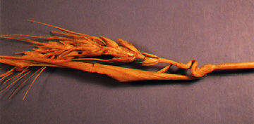
July 24, 2002 The Netherlands - Robert Boerman of the Dutch Crop Circle Archive called me tonight to report that two more circles have arrived in a Groote Keeten, northern Holland field that have a lot of twisted and bent seed heads, expulsion holes in the growth nodes and nodes that are cracked. He sent me some very good photographs tonight so I could see and compare them to similar anomalous stems from Avebury, Wiltshire and Whitefish, Montana in 1999. I'll begin with the historic background of the "somatic developmental abnormalities," named by W. C. Levengood, the Michigan biophysicist who has studied plants and soil from crop formations since the early 1990s.
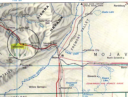
Tehachapi, California, the residence of Neil Browning since 1991, about 50 miles from Edward AFB. In that Mojave Desert and Tehachapi Mountains region, many people have reported hearing strange underground sounds, seeing unidentified triangles and other aerial craft, and even non-human entities. Rumors have long persisted that the area has underground installations, but no one specifies who operates them.
July 23, 2002 Tehachapi, California Last week I received an e-mail from 41-year-old Neil Browning of Tehachapi, California. Neil worked his entire U.S. Air Force career as a mechanic on airplanes until he retired as an E-7 in 1999. Then he took a position with the USAF Civil Service at Edwards AFB as an F-16 fighter aircraft crew chief. Neil Browning has lived in the same house in Tehachapi that he purchased in 1991. Between 1995 to 1999 he was on assignment in Korea and Luke AFB, Arizona and rented the house until he retired and moved back in full time.
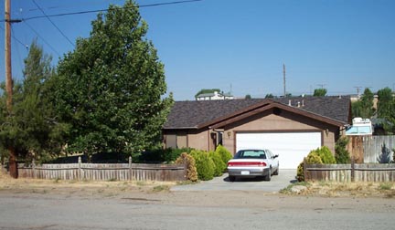
Neil Browning's house in Tehachapi, California west of Edwards Air Force Base where he works as an F-16 crew chief. His car is parked in front of the garage where the buzzing light encounter took place around 12:15 a.m. PDT on July 11, 2002. At the right beyond the fence is the trailer that Neil retreated to in fear after the encounter with the light in the garage. Photograph taken on July 23, 2002 by Neil Browning.
Click here to subscribe and get instant access to read this report.
Click here to check your existing subscription status.
July 20, 2002 Corvallis, Oregon A study by the World Wildlife Fund (WWF) was released this month which says that at the current rate of extinctions in 350 mammals, birds, reptiles and fish studied by scientists, in the middle of the 21st century, the oceans will be empty of marine life, forests will be gone and 25% of the world's mammal species could be extinct. Human over-population will have polluted water everywhere.
Click here to subscribe and get instant access to read this report.
Click here to check your existing subscription status.