Click here to subscribe and get instant access to read this report.
Click here to check your existing subscription status.
Existing members, login below:


Reported and Edited by Linda Moulton Howe
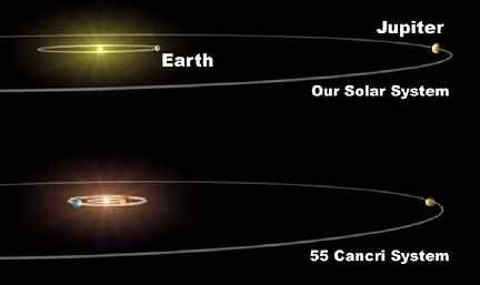
June 14, 2002 Pasadena, California - Today NASA's Jet Propulsion Laboratory announced that astronomers have discovered another solar system orbiting around the star 55 Cancri in the constellation Cancer which resembles our own sun and planets, at least in two large gaseous planets located at similar orbit distances. The first planet there was discovered in 1996 near that sun. The star 55 Cancri is 41 light years from Earth and is about the same age as our solar system, 5 billion years.
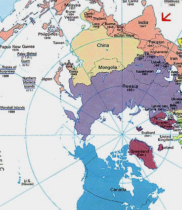
June 4, 2002 Tacoma Park, Maryland - If India and Pakistan strike each other with Hiroshima-sized bombs, how much radioactivity could reach the atmosphere and fall out around the world? That is a question I began asking a week ago and discovered that very little is known about the consequences downwind of such a catastrophe. The National Atmospheric Release Advisory Center (NARAC) at Lawrence Livermore National Laboratory in Livermore, California seemed like it should know. NARAC's public affairs office describes its "primary function is to support the Department of Energy (DOE) and the Department of Defense (DOD) for radiological releases." But when I asked an information officer there for information about the spread of radioactivity in the atmosphere from a nuclear war in Asia, the answer was, "That information is classified in the interests of national security."
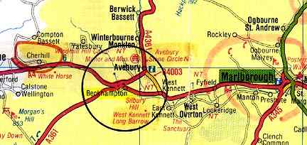
June 4, 2002 Avebury Trusloe, Wiltshire, England - For days prior to Saturday, June 1, rain had been falling hard on the crops in the famous farm county of Wiltshire, England. Then between the night of June 1 and 6 a.m. June 2, something touched young, green, 4-foot-high barley growing in a field near the famous and ancient ring of large sarsen granite stones in Avebury. The farm owner, a Mr. Butler, said he knew the barley was normal the day of June 1, so he was surprised and amazed to find a 180-foot-diameter formation of most intricate design at 6 a.m. on Sunday morning. According to Mr. Butler and a couple of other people who came along, the pattern was in pristine condition. No one could find tracks or other evidence of entry in the wet, rain-soaked mud.On June 2nd, Charles Mallett - new owner with his wife, Frances, of the Silent Circle Cafe in Cherhill not far from Avebury - heard about the new formation and went to see it. Charles has been in dozens of crop patterns and later talked with me by phone about his impressions.
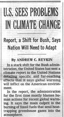
June 3, 2002 Boulder, Colorado - Today the Bush Administration and its Environmental Protection Agency made the front page of The New York Times above the fold with an admission that human burning of fossil fuels is largely responsible for increasing greenhouse gases around the earth and global warming. Times reporter, Andrew Revkin, based his report on a 268-page document quietly submitted earlier this spring by the EPA to the United Nations entitled, "U. S. Climate Action Report - 2002, the Third National Communication of the United States of America Under the United Nations Framework Convention on Climate Change." In that agreement with the U. N., the United States is honor bound to report every five years on the progress this county is making on environmental issues. Reporter Revkin said the EPA report "strongly concludes that no matter what is done to cut emissions in the future, nothing can be done about the environmental consequences of several decades' worth of carbon dioxide and other heat-trapping gases already in the atmosphere.
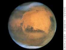
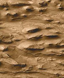
June 1, 2002 Pasadena, California - Since NASA's 1976 Viking missions, Mars has been thought by most people to be dry, dusty and dead, marked with ancient river channels and gullies that meant water had been there once upon a time. For several decades, traces of atmospheric water and some water ice along with frozen carbon dioxide at the poles had been known. But where had all the water gone that had once flowed through the rivers and canyons? Apparently, the oxidized, rusty surface has been deceiving. Less than a meter below the red rocks and dust in very cold regions, scientists have found a signal for the element hydrogen that is so strong it's assumed to be frozen H2O (water), according to this week's journal Science.
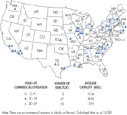
May 25, 2002 Washington, D. C. - This Memorial Day weekend, the U. S. government has announced several terrorist threat warnings. The latest came from the Nuclear Regulatory Commission placing all 103 nuclear power plants throughout the country on a heightened state of alert. This weekend the FBI also warned of possible underwater terrorist attacks by scuba divers that could target nuclear power plants as well. Recently intelligence sources warned that on the Fourth of July, Pennsylvania's Three Mile Island (TMI) could be the target of an Al Qaeda attack. In fact, there is concern that spent radioactive fuel could be stolen to produce a dirty bomb to be set off at nuclear power plants.
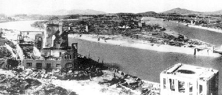
May 25, 2002 Washington, D. C. - The terms "suitcase nukes" and "dirty bombs" do not refer to the same radioactive weapon. A suitcase nuke in the 21st Century is about the size of the atom bomb the United States dropped on Hiroshima and Nagasaki in 1945 that ended World War II. Bomb making technology advanced so much during the Cold War with the Soviet Union that scientists were making similar bombs as small as suitcases, hence the name. Building atomic bombs, small or large, is not easy and the only country thought to have such weapons is Russia. But no one knows for certain where suitcase nukes might be or if any have been sold to countries such as Iran or Iraq.
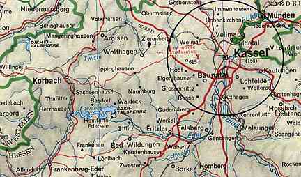
May 23, 2002 Kassel, Germany - The www.invisiblecircle.de researchers in Germany report a third crop formation near Kassel, discovered on May 20, 2002 by Dirk Moeller. The two part formation was in young barley near a geographic site known as the "riesenstein," or giant's stone near the village of Zueschen. All three 2002 Germany formations have been near Kassel; the first at Fritzlar southeast of Kassel found April 26 and the second around the same date north of Kassel. See 05/04/02 Earthfiles.