More Big Basin, California, Bizarre “Drone” Images

"It was rotating, slowly, but often changing direction from clockwise to counterclockwise randomly."

- Ty B., Big Basin, California

Big Basin Redwoods State Park is northwest of Santa Cruz, California.

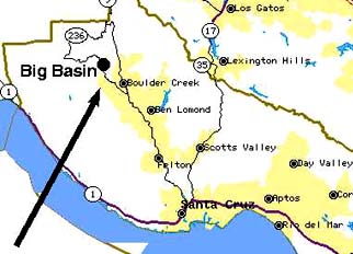
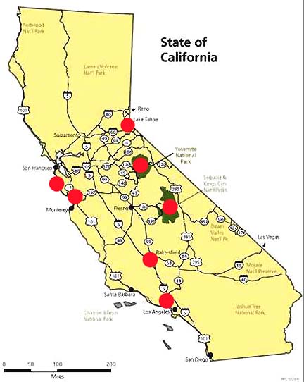
June 17, 2007 Big Basin, California - In yesterday's post office mail, I received twelve more images of the latest, more menacing-looking dragonfly-shaped aerial "drone," along with a letter mailed on June 11, 2007, from an eyewitness named Ty. He had also emailed me on June 11, telling me that he was sending photographs he had taken while bicycling with a group of riders near Saratoga, California, in Big Basin. Ty said the cycling group saw the bizarre aerial object three times on June 5, 2007. He said in his email that he was surprised to see at Earthfiles the images allegedly taken by someone named "Stephen" that showed the same object Ty and his friends watched appear and disappear also on June 5, 2007, and that Ty photographed.


Click here to subscribe and get instant access to read this report.

Click here to check your existing subscription status.

Existing members, login below:

Part 2: Star Wars Physicist Edward Teller, Outer Space Menace And Remotely Piloted Vehicles (RPVs)

Return to Part 1

June 15, 2007 Albuquerque, New Mexico - The following alleged government document is reprinted in full. Originally leaked to Bob and Ryan Wood for their Majestic-12 documents project at majesticdocuments.com. The document is entitled “Edward Teller’s Pitch to President Reagan for SDI" (Strategic Defense Initiative). The date is July 2, a year or two after Ronald Reagan became president in January 1981.

President Ronald Reagan awarded physicist Edward Teller, Ph.D., the National Medal of Science in 1983. Image courtesy Lawrence Livermore Laboratory.


Click here to subscribe and get instant access to read this report.

Click here to check your existing subscription status.

Existing members, login below:

Part 1: Yosemite National Park and Northridge, California, Aerial Dragonfly “Drones”

“It was like the moment the flashlight light hit the thing, it jerked very quickly and started to move in another direction.”

- Yosemite Park Drone Eyewitness

Click for podcast.
Click for podcast.

“That strange aerial object above the tree was a brilliant, fluorescent apple green in the shape of a horseshoe crab sideways (profile) with a long tail.”

- Robert Mariotti, Northridge Drone Eyewitness

Red circles mark sites where odd, aerial drones have been reported in California, including Big Basin Redwood State Park and Capitola north of Monterey; Lake Tahoe; Yosemite National Park; Sequoia and Kings Canyon National Park; Bakersfield general region; and Northridge, California, near Los Angeles. Outside California eyewitness locations have been May 2006 in Birmingham, Alabama; 1987 in Barksdale AFB, Louisiana; and June 25, 2007, near Maxwell AFB, Montgomery, Alabama.

June 15, 2007 Canoga Park, California - Since the first week of May, seven people in California, one in Birmingham, Alabama, and another from Louisiana – for a total of 9 - have reported seeing a dragonfly-shaped aerial object in the sky that has a ring body, a long tail and variations of appendages extending from the ring.


Click here to subscribe and get instant access to read this report.

Click here to check your existing subscription status.

Existing members, login below:

High Strangeness Encounter in Tucson, Arizona

"Though the vehicle emitted a soft brass glow, I could see my distinct shadow on its grooved, sloped surface...Whenever I took a few teps along the object's circumference and then stopped, my shadow took an extra step."

- W. Scott Frank

In the eastern city limits of Tucson, Arizona, is Davis Monthan AFB. Southeast is Fort Huachuca, long associated with underground facilities linked to monitoring, or interacting with, a non-human intelligence.

June 14, 2007  Albuquerque, New Mexico - Recently I met an Albuquerque resident who has had high strangeness in his life since childhood. Now in his mid-fifties, W. Scott Frank is trying to make some sense of his odd experiences by writing them out for a book manuscript he hopes to publish one day. An especially haunting event that involved another intelligence's mind manipulation, mimicry and illusions occurred at the end of 1976 in Tucson, Arizona, when Scott was in his mid-twenties. Scott Frank gave me permission to reprint "By the Curve of the Tracks" as an Earthfiles Real X-File.


Click here to subscribe and get instant access to read this report.

Click here to check your existing subscription status.

Existing members, login below:

Into the Unknown with George Noory

"Gary Busey (screen actor) believes that as he lay near death in the hospital after his motorcycle accident, he was visited by some kind of orbs – or maybe angels. He calls them ‘balls of light’ and truly believes he had gone over to the other side."

- George Noory

June 13, 2007  Los Angeles, California - The SciFi Channel tries out a new TV pilot on Wednesday, June 13, 2007, at 11 PM ET / 10 PM CT, that features George Noory interacting with a live studio audience as he does Monday through Friday hosting Premiere Radio Network's Coast to Coast AM. The nightly 4-hour radio broadcast is distributed to more than 500 Premiere Radio Network stations in the United States and Canada.


Click here to subscribe and get instant access to read this report.

Click here to check your existing subscription status.

Existing members, login below:

2005 and 2006 Memphis “Drones”?

Upper red circle is Millington where the Naval Air Station once was and today provides Naval Support Activity (NAVSUPPACT) Mid-South, a Naval hub for personnel records. Red circle in central Memphis is where Kathleen Deaton, 44, lives and saw a "sperm-shaped" aerial object in June 2005, stop and change altitude several times over backyard deck and house roof. The red circle in Bartlett is where Sandra Smith, 72, in October 2006, saw a "plane" stop three times in mid-air, jerk forward and then vanish.

July 10, 2007  Memphis, Tennessee -  On June 28, 2007, I received an email with the subject line, "drones," from Kathleen Deaton, 44, who lives with her husband and children in central Memphis. Her email began: "Back in 2005, I was sitting on my deck here in Memphis, Tennessee, in June. At about 3:30 PM, ...I turned around to see one of the most incredibly odd things I've ever seen. It looked like a big sperm cell - it was an opaque balloon of some sort with a tail which seemed to propel it. ...It was flying about 20 feet off the ground, coming between the trees and other houses, and was flying right over my backyard directly towards my deck and me."


Click here to subscribe and get instant access to read this report.

Click here to check your existing subscription status.

Existing members, login below:

More Drone Photos and Other Eyewitnesses

Return to:  Birmingham-Type "Drone" Seen At Barksdale AFB, La., in Mid-1980s.

Return to:  Previous Odd Aerial "Drone?" Earthfiles.

Return to:  Engineer Comments About Odd Aerial "Drone?" Earthfiles.

Return to:  Odd Aerial "Drone"? Photographed Again Over Capitola, California.

Return to:  Letters About Unidentified "Drone" Aerial Objects.

June 8, 2007  Albuquerque, New Mexico - On June 7, 2007, Ufocasebook.com received three more "drone" images (by "Stephen") allegedly taken in Big Basin Redwoods State Park, California, northwest of San Jose, on June 5, 2007. This is a more sinister-looking machine than the previous four versions: Central California (Chad); Lake Tahoe (MUFON); Capitola (rajman1977); and Birmingham, Alabama (John Smith). See accompanying letter below in More Information.


Click here to subscribe and get instant access to read this report.

Click here to check your existing subscription status.

Existing members, login below:

Bird Eggs Undamaged in Slovenia Crop Formation

Ptuj, Slovenia, is marked by red circle, southeast of Graz Austria (yellow).

June 7, 2007  Ptuj, Slovenia - Today I received an email from Omer Sabic in Slovenia, a country bordered by Austria, Hungary, Croatia and Italy.


Click here to subscribe and get instant access to read this report.

Click here to check your existing subscription status.

Existing members, login below:

Part 3: U. S. Crop Formations, Wheat Pictogram in Madisonville, Tennessee

"The physical data knocks out the chance that people hoaxed this. People just cannot hoax the expulsion cavities and they cannot elongate the growth nodes..."

- Jeffrey Wilson, ICCRA

 Madisonville, Monroe County, Tennessee - site of the historic Cherokee nation's capital, Chota - is straight south of the Oak Ridge National Laboratory outside Knoxville and west of the Great Smoky Mountains.
Madisonville, Monroe County, Tennessee - site of the historic Cherokee nation's capital, Chota - is straight south of the Oak Ridge National Laboratory outside Knoxville and west of the Great Smoky Mountains.

Return to Part 1U. S. Crop Formations in Epps, Louisiana, and Red Bluff, Calif.

Return to  Part 2:  U. S. Crop Formations, Two Mysterious Grass Circles in Mission, Kansas.

June 7, 2007  Williamsburg, Ohio   -  On May 24, 2007, I received a phone call from Jeffrey Wilson, Director of the Independent Crop Circle Research Association (ICCRA) in Williamsburg, Ohio, telling me that the Monroe County Buzz newspaper in Madisonville, Tennessee, had a headline about a crop formation in a wheat field. Madisonville, Monroe County, Tennessee - site of the historic Cherokee nation's capital, Chota - is straight south of the Oak Ridge National Laboratory outside Knoxville and west of the Great Smoky Mountains (red circle on map).


Click here to subscribe and get instant access to read this report.

Click here to check your existing subscription status.

Existing members, login below:

Part 2:  Yatesbury, England and Madisonville, Tennessee – A Mayan Link?

Top:  Yatesbury Field, Wiltshire, England, reported May 30, 2007, fifty-seven swirled barley circles in large spiral about 300 feet in diameter. Bottom: Madisonville, Tennessee, wheat pattern about 170 feet in diameter with crop laid down in counterclockwise circles discovered from airplane on May 15, 2007. U.K. aerial image © 2007 by Lucy Pringle. Tennessee aerial © 2007 by Mark Boring, Co-owner and Editor, Monroe County Buzz.

Return to Part 1: Yatesbury Spiral - Viewer Comments on Spiral Math

June 6, 2007  Yatesbury Field, Wiltshire, England - Two crop formations an ocean apart - one in English barley near the ancient and sacred ground of Avebury Trusloe on Yatesbury Field; the other in a Madisonville, Tennessee, wheat field not far from the historic Cherokee Indian capital of Chota and even more ancient 9,500-year-old Icehouse Bottom. (See Part 3: Madisonville Circles.)  The English pattern has fifty-seven circles threaded on a thin, 4-inch-diameter spiral. The Tennessee pattern has nine circles with a triangular "pointer" in the middle standing circle that aims west in the opposite direction from Chota.


Click here to subscribe and get instant access to read this report.

Click here to check your existing subscription status.

Existing members, login below: