"A symbiosis of methanogenic bacteria with methanothrophic bacteria in the Martian underground can be an alternative interpretation (to geothermal) and looks more likely."
- Vittorio Formisano, Ph.D.
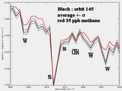
September 20, 2004 Ischia Island, Italy - Today at the International Mars Conference held September 19-23, by the Italian Space Agency, physicist Vittorio Formisano, Ph.D., presented results from his analysis of the Martian atmosphere in a paper entitled, "Observation of Methane, Formaldehyde and HS (hydrogen sulfide): Extant Life On Mars?" Dr. Formisano designed the Planetary Fourier Spectrometer (PFS) for placement on the European Space Agency's Mars Express Orbiter. Back on May 6, 2004, when I interviewed him for Earthfiles and radio, he said his PFS data indicated molecules of formaldehyde in the Martian atmosphere and told me, "Formaldehyde is destroyed in the Martian atmosphere within 7.5 hours. There is no way that formaldehyde can exist and remain for a long time in the Martian atmosphere. If (formaldehyde) confirmed, possibly life on Mars today, yes."