July 18, 2001 Hartsville, Tennessee Today I learned from Ted Randall that dead birds with burned wings were found all over Hartsville's city park, a diameter of at least a mile. In fact, in the afternoon of that same day, power surges and dimming lights were reported at an insurance company more than a mile from WJKM. This afternoon, I talked with Ted Randall and Dave Fluehe, owner of Dave's Covert Surveillance in Hartsville who provides electronic camera and video security monitoring equipment to businesses. On July 6 in the afternoon, Dave Fluehe was in an insurance company more than a mile away from WJKM when more electronic interference occurred.
Click here to subscribe and get instant access to read this report.
Click here to check your existing subscription status.
July 14, 2001 Hartsville, Tennessee - Friday, July 6, was a clear and sunny morning. But at 10:45 a.m., something very odd surged through the air, radio transmitter, power and phone lines at country music radio station WJKM (1090 AM) near the city park in downtown Hartsville, Tennessee. It also affected theVidette newspaper office next door and shocked one of the employees sitting at her desk.
Click here to subscribe and get instant access to read this report.
Click here to check your existing subscription status.
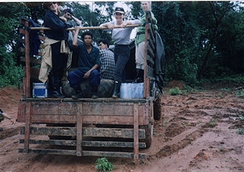
On the rugged road to Vilabouli (Vilaburi), left to right: Producer Denise Blazek from Perth, Australia; Soundman Martin Geissmann from Bangkok, Thailand; a Laotian guide; Soukhasavanh Sanaphay, Vientiane Ministry of Foreign Affairs Press Department; Reporter Linda Moulton Howe; Associate Producer Jax Hayes, Bang Productions Ltd., Hong Kong. Photograph by Videographer Brad Dillon from Hong Kong.
July 12, 2001 Xepon, Laos – On June 29, the Bang Productions Ltd. crew, Phoudai Travel representatives, Mr. Soukhasavanh Sanaphay of the Vientiane Ministry of Foreign Affairs Press Department and I got into an old Soviet military truck in Xepon, Laos to follow the trail of “Wild Men” sightings.Click for report.
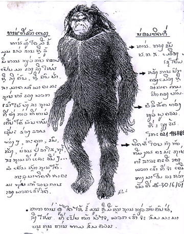
Drawing by Alika Lindbergh based on sketches by Bernard Heuvelmans, Ph.D., and Boris Porchnev in Plate 48 of their book, L’Homme de Neanderthal est Toujours Vivant, Paris, 1974, and used in the Laos adventure to show local residents in markets.
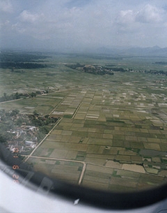
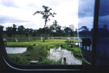
July 8, 2001 Vientiane, Laos – On Tuesday, June 26, 2001, the Bang Productions, Ltd. crew and I flew from Hong Kong to Hanoi, Vietnam. Through the airline window, I took a photo of the miles of rice fields near the airport, a prelude to the beautiful, watery fields that stretched along all the roads we would travel in Laos.
After changing planes in Hanoi, we flew to Vientiane, the capitol of Laos since the mid-16th Century when political power shifted from Luang Prabang (now Louangphrabang), the former royal center. The chief occupation in Laos is agriculture. An estimated 90 percent of the people farm rice. For centuries, political upheavals by powers mainly outside Laos have erupted, including the Vietnam war of the 1960s to 1970s. Yet, Laotian culture has remained closely tied to Buddhist religions and its own traditions of art, literature, music and drama that are largely free of western influence.
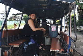
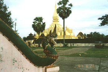
After checking in the hotel, Producer Denise Blazek and I took off on a location scout to visit some of the Buddhist stupas by open air taxi.
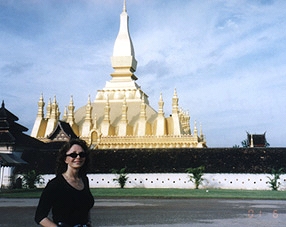
The largest and most spectacular is the Phrathatluang that is said to house some bones from the Lord Buddha. Mr. Soukhasavanh Sanaphay from Vientiane’s Ministry of Foreign Affairs Press Department told me that the shiny gold surface was made from melted gold coins.
A sign posted in front says in both the Lao language and English:
“PHRATHATLUANG – This stupa the original it was built in the 3rd Century and established of the Muang Vientiane in the same time. The stupa for the contain are some bone of the Lord Buddha. The original a small stupa made by stone during the reign of the great King Xaisethathirath in 16th Century. After the king removed from the Luangphrabang reach to Vientiane in 1560 A.D. and in 1566 A.D. the king has enlargement of the Phrathatluang as we have seen at the present.”
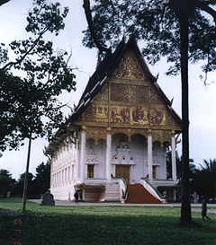
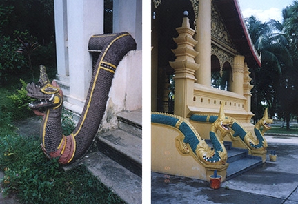
Nearby is a monk’s house upon which are golden scenes of the Buddha’s life above steps protected by two Nagas, Sanskrit for “serpent.”
In Hindu and Buddhist mythology, Nagas are semi-divine beings, half human and half serpentine. Their race is said to be strong and handsome and the beings can assume either human or serpentine form. Nagas are superior to humans and considered to be potentially dangerous. Their location on earth is an underground kingdom called Naga-loka, or Patala-loka, which is filled with palaces decorated with precious gems. Brahma himself, the personification of divine reality in a trinity with Vishnu and Shiva, is said to have relegated the Nagas to the underground after their population had grown too large on the surface of the earth. Brahma also commanded the Nagas to bite only the truly evil and so Nagas are frequently carved as door guardians.
The snake king, Mucalinda, protected the Lord Buddha from rain during a seven day meditation. Subsequently, when Nagas are depicted as human beings, there is often a canopy of many snakes over their heads. Nagas are also depicted as half-human with the lower part of their body below the navel coiled like a snake and a canopy of snake hoods over their heads.
There will be more about Naga mythology in the Bang Productions Ltd. series Modern Mysteries of Asia scheduled for air on The Discovery Channel in late November 2001.
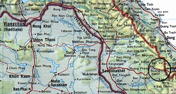
From Vientiane, our group and all the photographic gear were split into two busses for a long road trip to Savannakhet and on to Xepon on the trail of the “Wild Men” of Laos.
Route from Vientiane, Laos, to Savannakhet and then east to Xepon and the rugged mountan country beyond near Vilaburi (Vilabouli), Laos, and the Vietnam border where “Wild Men” Sasquatch/Bigfoot-type creatures have been reported.
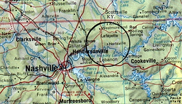
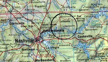
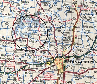
Dadeville, near the center of the circle, is about 40 miles northwest of Springfield, Missouri.
June 22, 2001 Dadeville, Missouri - James Lee Roy has been raising cattle on a farm in Dadeville, Missouri for fifty years. He and his wife, Genevieve, bought their current pastures twenty years ago and now keep about 100 cows for beef sales. Wednesday, June 5, he found his second mutilated calf since 1990.
Click here to subscribe and get instant access to read this report.
Click here to check your existing subscription status.
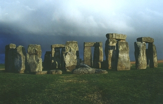
June 16, 2001 Washington, D. C. - Astronomer Gerald S. Hawkins, Ph.D., educated at Manchester University in England and now retired in Washington and Virginia, wrote a book in 1973 entitled Beyond Stonehenge. The Daily Express in London wrote about it, "If Hawkins is right, and most experts now agree that he must be, then Stonehenge is the Eighth Wonder of the ancient world."
Click here to subscribe and get instant access to read this report.
Click here to check your existing subscription status.
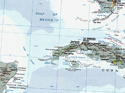
Western tip of Cuba, not far from the Yucatan Peninsula, where unusual sonar images at 2,200 feet suggest unnatural structures covering several square kilometers.
June 13, 2001 Havana, Cuba - When I reported last month on COAST about the Cuba discovery, I had an interview with Barbara Moffet, Director of Plans and Programs at the National Geographic Society in Washington, D. C., who confirmed that the Society was aware of the deep water mystery off the western tip of Cuba. She said NGS was communicating with Paulina Zelitsky and her husband, Paul Weinzweig, partners in Canada's Advanced Digital Communications company, known as ADC. Last month, National Geographic was trying to decide whether to help fund a dive in a remotely operated vehicle with cameras to see what is down there. Today, I talked again with Barbara Moffet and she confirmed that National Geographic has now made an agreement for exclusive magazine coverage.
Click here to subscribe and get instant access to read this report.
Click here to check your existing subscription status.
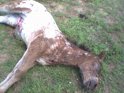
Three-month-old male colt found dead the morning of May 25, 2001 on a horse farm owned by Mike and Rose Downs of Leitchfield, Kentucky. Photograph courtesy Sheriff Joe Brad Hudson, Grayson County Sheriff's Department.
June 9, 2001 Washington, D. C. - This week President George Bush heard his own personally hand-picked scientific panel tell him that global warming is real, man-made, poses threats in the future and that the global temperature could rise between 2.5 and 10.4 degrees Fahrenheit over this century. When Bush created the panel in March, the President said he was unsure that global warming was a real phenomenon. Now his own panel of climate experts, including a Nobel Prize winner and members of the National Academy of Sciences, has answered with these sobering words:
Click here to subscribe and get instant access to read this report.
Click here to check your existing subscription status.