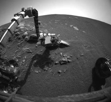
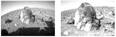
Part 3 – Paint Creek Island, Ohio Crop Formation Photographs

October 5, 2003 Bainbridge, Ohio - The following photographs were taken by Jeffrey Wilson during his field investigation of the Paint Creek Island, Ross County, Ohio, formation in soybeans on September 28, 2003. The formation is four miles west of the ancient Seip Mound and about thirty miles from the Serpent Mound. This is the third formation at the mounds in 2003.

Paint Creek Island, near Bainbridge in Ross County, Ohio, formation in soybeans about 30 miles from the Serpent Mound pattern - both probably occurred around same date of August 24, 2003. Aerial photograph © 2003 by Dan Music and Jeffrey Wilson.


Click here to subscribe and get instant access to read this report.

Click here to check your existing subscription status.

Existing members, login below:

Part 1 – Update On Deep Water Megalithic Stones and Structures Near Western Cuba

Northeast of Cabo San Antonio, marked in yellow, and down about one-half mile off the western tip of Cuba are large stones in rectangular and pyramidal shapes. There are also huge unidentified structures that have 90-degree corners and are spread along straight corridors on the white sea floor sand.
Original high resolution side scan sonar images of large structures a half mile down on the white sand sea floor off the western tip of Cuba, received by an ADC International, Inc. expedition in 2000 directed by Paulina Zelitsky and Paul Weinzweig, Owners, Advanced Digital Communications International, Inc. of Havana, Cuba. Sonar images © 2000 by ADC International, Inc. and used with permission.

September 24, 2003  Havana, Cuba - It was a summer day in 2000 that the first surprising side scan sonar images of what looked like architecture were seen a half mile down off the western tip of Cuba. The ocean floor there is very flat and covered with white sand. The camera was run by the Remote Operated Video control room on the "BIC Ulises" ship owned and operated by engineer and oceanographer, Paulina Zelitsky, and her husband and business partner, Paul Weinzweig ­ co-owners of Advanced Digital Communications International, Inc. ­ or ADC International, Inc. Paulina was born and educated in the Soviet Union and was assigned to work in Cuba. Later, after she married Paul, a Canadian citizen, ADC was based in Canada. More recently, ADC International has become an international business company incorporated in the Commonwealth of the Bahamas to conduct deep ocean bottom survey in the Caribbean and Gulf of Mexico.


Click here to subscribe and get instant access to read this report.

Click here to check your existing subscription status.

Existing members, login below:

Astronomers Discover Asteroid That Might Hit Earth in 2014

"Scientists already know of 113 Potentially Hazardous Asteroids (PHAs) tumbling on paths that will eventually lead them to within an astronomical hair's width of Earth. The total number of such asteroids could be well over a thousand."

- EarthSky.com

Top: The 1994 XM asteroid appeared as a trail in images taken on December 9, 1994. Bottom: Compare to image on right which shows the asteroid some 4.5 hours later. The asteroid was about 550,000 kilometers away from Earth at the time, on its way to a record close approach of some 105,000 kilometers (65,258 miles) only 12 hours later.

Updated -  The Jet Propulsion Lab's Paul Chodas, a research scientist who specializes in calculating the orbits of asteroids and other near-Earth objects, announced today that asteroid 2003 QQ47 is not on a collision course with Earth in March 2014. Chodas said, "This particular one was of interest because it is fairly large, 1.3 kilometers [0.8 mile], and the predicted impact was only ten years away. Combining those two factors, we raised it to some level of concern."

September 2, 2003  Cloudcroft, New Mexico - The first eyes to see the new asteroid threat called "2003 QQ47" are at the Lincoln Near Earth Asteroid Research Program at MIT in Cambridge, Massachusetts. LINEAR, as it's known to astronomers, was an outgrowth of the Ballistic Missile Defense Organization (BMDO) that took over the Reagan Administration's Star Wars program. LINEAR rose from the development of very high tech surveillance equipment that was originally designed to look for orbiting space junk high above our planet. Scientists already know of 113 Potentially Hazardous Asteroids (PHAs) tumbling on paths that will eventually lead them to within an astronomical hair's width of Earth. The total number of such asteroids could be well over a thousand. And this newly discovered one is about two kilometers in diameter - big enough to do serious damage on Earth if it hit us.


Click here to subscribe and get instant access to read this report.

Click here to check your existing subscription status.

Existing members, login below:

Volcanic and Seismic Threats to Northwest U. S.

"The effects of an eruption of Mt. Rainier, the severe effects, would be much smaller than the effects of the potential 9 Richter earthquake that can happen off the Pacific northwest. That earthquake will affect areas from northern California to southern British Columbia."

­ William Scott, Ph. D., USGS Cascades Volcano Observatory

Moderately active volcano, Mount Rainier, looms in the background of Tacoma, Washington, population 194,000. Its last major eruption was 500 years ago. Photograph by Lyn Topinka, U. S. Geological Survey.
Mt. Rainier is near center of map between Olympia and Tacoma, Washington.

August 29, 2003 Vancouver, Washington - Along the northwest coast of the United States and southern British Columbia, Canada, there is a volcanic range called the Cascades. There are thirteen Cascades volcanoes which have been intermittently active for hundreds of thousands of years ­ the latest being Mount St. Helens on May 18, 1980. Another moderately active volcano is Mt. Rainier near Olympia and Tacoma, Washington and could directly affect the lives of more than a hundred thousand people who now live on or near the lower slopes of the mountain.


Click here to subscribe and get instant access to read this report.

Click here to check your existing subscription status.

Existing members, login below:

No Ancient Oceans On Mars? Only Glaciers?

"Mars has probably always been very cold and if (occasional melted) water rushed out of those massive outflow channels and flowed out onto the northern plain, it likely froze very quickly."

­ Philip Christensen, Ph.D., Planetary Geologist, Arizona State University

Hubble Telescope image of Mars and the largest canyon in the solar system, Valles Marineris, that stretches for 2,500 miles (4,000 km).

August 27, 2003 Tempe, Arizona - Observations of Mars go back to the 1700s. People saw bright and dark markings on Mars and they speculated that the dark areas were oceans and the bright regions were continents. So, the idea of oceans on Mars has been postulated for three hundred years.


Click here to subscribe and get instant access to read this report.

Click here to check your existing subscription status.

Existing members, login below:

Mars At Its Closest August 27, 2003, At 2:51 a.m. PDT / 5:51 a.m. EDT.

Mars At Its Closest August 27, 2003,
At 2:51 a.m. PDT / 5:51 a.m. EDT.

Mars image by Hubble Telescope.

This week, Mars rises at 6:30 p.m. PDT / 9:30 p.m. EDT in the southeastern sky as it approaches what is known as "Mars opposition." Like a full moon, the red planet will be facing the Earth (opposition) and opposite the Sun on August 28, 2003. Mars will have reached its closest approach to the Earth in 60,000 years the day before on August 27 - only 34,650,000 miles away.


Click here to subscribe and get instant access to read this report.

Click here to check your existing subscription status.

Existing members, login below:

First 3-D Images of the Sun’s Granular Surface

Black tick marks at the perimeter of this solar image are 1000 kilometers (622 miles) apart. Each granule, or cell, on the sun's surface is about the size of Texas. This image near the eastern limb of the sun was first taken on July 24, 2002, by Prof. Goran Scharmer and processed by Dr. Mats G. Lofdahl, Institute for Solar Physics, Royal Swedish Academy of Sciences.

July 16, 2003 Palo Alto, California - At the recent American Astronomical Society's Solar Physics Division meeting in Laurel, Maryland, solar physicists from Lockheed Martin Solar and Astrophysics Lab (LMSAL) at the company's Advanced Technology Center in Palo Alto, California, along with other European scientists, presented the highest resolution images ever taken near the visible edge of the sun.


Click here to subscribe and get instant access to read this report.

Click here to check your existing subscription status.

Existing members, login below:

Earthfiles