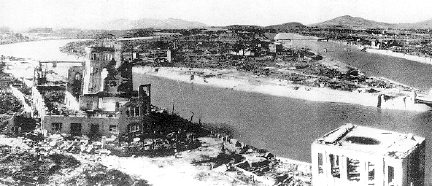
Third 2002 Crop Formation in Germany Near Giant’s Stone

All three of Germany's 2002 crop formations since April 26 have been in the Kassel region, long famous as the "hot spot" for German crop patterns.

May 23, 2002  Kassel, Germany - The www.invisiblecircle.de researchers in Germany report a third crop formation near Kassel, discovered on May 20, 2002 by Dirk Moeller. The two part formation was in young barley near a geographic site known as the "riesenstein," or giant's stone near the village of Zueschen. All three 2002 Germany formations have been near Kassel; the first at Fritzlar southeast of Kassel found April 26 and the second around the same date north of Kassel. See 05/04/02 Earthfiles.


Click here to subscribe and get instant access to read this report.

Click here to check your existing subscription status.

Existing members, login below:

A Bull Mutilation in Christmas Valley, Oregon

Dozens of animal mutilations and strange unidentified aerial lights have been reported   over several decades in Oregon's Sand Springs region and south into Christmas Valley.
Dozens of animal mutilations and strange unidentified aerial lights have been reported over several decades in Oregon's Sand Springs region and south into Christmas Valley.

May 18, 2002  Fort Rock, Oregon - There is a new report from the Lake County, Oregon Sheriff's Office this month of a bull mutilation in the Christmas Valley of Oregon southeast of Bend. It seems to be a continuation of animal mutilations and very strange aerial lights near the Sand Springs region over the past several decades. One rancher there in 1980 even described seeing cattle drawn up into glowing discs in the sky and dropped back down to the ground, dead and mutilated, the weight of their bodies making craters in the dusty soil. Oregon resident, Dwain Wright, talked with that Sand Springs rancher and described the incident for me when I was producing my documentary Strange Harvests 1993 and my book Glimpses of Other Realities, Vol. II: High Strangeness (see Earthfiles Shop). Here is a brief excerpt from that interview:


Click here to subscribe and get instant access to read this report.

Click here to check your existing subscription status.

Existing members, login below:

Two Crop Formations Near Kassel, Germany

Fritzlar, a rural community south of Kassel, was the location of the first 2002 formation in Germany discovered by the farmer on April 26. The second formation north of Kassel in an area kept secret at the farmer's request was discovered on May 1, but thought to have been formed earlier, most likely at the same time as the first formation.

May 4, 2002  Saarbruecken, Germany - Crop formation investigator, surveyor and author, Andreas Mueller, reported to me today that two formations have been discovered south and north of Kassel, Germany in oil seed rape so young it had only begun to open its bright yellow flowers. Both formations are thought to have been created the same night on Thursday, April 25. The first near Fritzlar south of Kassel was found by the farmer on Friday, April 26. The second was found May 1 north of Kassel, but the condition of the crop indicated the plants had gone down earlier. In previous years, Kassel has had two formations arrive at the same time and, like Avebury in England, is the geographic focus of the crop phenomenon in Germany. See More Information at the bottom of this report and my Earthfiles reports beginning 05/19/01 about last year's prolific season in Germany.


Click here to subscribe and get instant access to read this report.

Click here to check your existing subscription status.

Existing members, login below:

Earth’s Magnetic Anomalies – Could the Poles Flip?

Computer-generated snapshot of lines of force in the Earth's magnetic field beginning at the Earth's surface from where they penetrate smoothly into the insulating mantle. The structure changes dramatically in the liquid core below the mantle where the magnetic field is generated by the convection of the core's melted iron. Graphic courtesy Gary A. Glatzmaier, EE-IGPP, Los Alamos National Laboratory and Paul Roberts, University of California-Los Angeles.

April 27, 2002  Cambridge, Massachusetts - Deep beneath our feet as we walk around ­ in fact, 4,000 miles down ­ is the center of the earth where an iron core is so hot it is liquid and boils around like cooking porridge. That moving, melted iron also produces the magnetic fields that surround the earth and upon which much of earth's surface life, satellites and space technology depend upon for orientation, and for protection. If magnetic fields did not trap highly energetic particles racing from the sun, all kinds of damage could be done to living organisms and space technologies. For nearly a million years, magnetic field lines have been coming out of the south pole and entering the north pole of the earth. That is called the magnetic dipole.


Click here to subscribe and get instant access to read this report.

Click here to check your existing subscription status.

Existing members, login below:

John Anthony West Organizing New Effort to Date Weathering of Sphinx and Red Pyramid Chamber

A 20th Century photograph of the Sphinx showing weathering and damage from deliberate attacks over the ages, Cairo, Egypt. The Sphinx was carved, method unknown, from one single ridge of stone that was 240ft long. Its length is 150 feet and the paws alone are 50 feet. Its height is 66 feet. The head measures 30 feet long and 14 feet wide.

April 23, 2002  Athens, New York - In 1991, Egypt researcher John Anthony West joined Boston University geologist, Robert Schoch, Ph.D., to study the weathering on the base of the Sphinx. Dr. Schoch's academic opinion was water damage at least eight thousand years ago and the two men announced their theory which made worldwide headlines. Since then, two British geologists named David Coxill and Colin Reader have independently traveled to Cairo to study the Sphinx and each has supported Dr. Schoch's conclusion that the weathering is from water. But no one yet has definitively proved how long ago there was enough rain to weather the Sphinx.


Click here to subscribe and get instant access to read this report.

Click here to check your existing subscription status.

Existing members, login below:

Chronic Wasting Disease Spreads to Wisconsin White-Tailed Dee

The Wisconsin Department of Natural Resources haas confirmed ten cases of deadly chronic wasting disease (CWD) in wild white-tailed deer, the first such cases east of the Mississippi River. Photograph © 2001 by Roger Barbour Kuhn.


April 6, 2002  Madison, Wisconsin - On February 28th, the Wisconsin Department of Natural Resources (DNR) confirmed three cases of deadly chronic wasting disease (CWD) in free ranging white-tailed deer in the Mount Horeb area of western Dane County. This week that number jumped to ten. Since March 5, 2002, the DNR has collected 197 deer samples from that region and plans to collect 300 more. CWD is a prion disease that attacks brains and nervous systems similar to mad cow in cattle, scrapie in sheep and new variant Creutzfeldt-Jakob and kuru in humans. The culprit in both animals and humans is called a prion. Prion stands for proteinaceous infectious particles. More simply, prions start out as normal proteins that mysteriously change shape and then destroy brain and nerve tissue. To this date, no one knows what caused the proteins to change shape in the first place or how misshapen proteins are transmitted. There is no blood test to find prions while animals are alive and no cure after prions are confirmed. Death usually occurs within weeks or months.


Click here to subscribe and get instant access to read this report.

Click here to check your existing subscription status.

Existing members, login below:

Scientists Investigate Dark Coastal Waters of Southwest Florida

NASA showed this March 21, 2002 Goddard Space Flight Center SeaWiFS image captioned, "Mysterious black water blankets Florida Bay." The dark water between Naples and the Florida Keys was first reported by fishermen and pilots back in January. By the middleof March, the dark waters had spread to an estimated 100 miles and scientists began to take and analyze water samples. Satellite image courtesy NASA.


April 1, 2002  Marathon, Florida - Fishermen who have spent their lives catching marine life in the waters between Naples and the Florida Keys began calling news media in January to report massive areas of water so dark and dense it was eerie and many said they had never seen anything like it before. By the middle of March, NASA satellite images clearly showed dark waters that at one point spanned an estimated 100 miles. Fishermen also noted that dead plants from the ocean floor seemed to rise up and follow the movement of the dark water through Florida Bay and the Keys. Fish seemed to turn away from the dark currents and eventually scientists discovered that coral and sponges had died or were dying in certain channels where the dark waters had been.


Click here to subscribe and get instant access to read this report.

Click here to check your existing subscription status.

Existing members, login below:

Drought Worsens in United States

"If we don't have replenishing rains that really begin to fill the reservoirs and ... start refilling some of the groundwater tables, then we're going to continue to deplete our water resources and the economic and environmental impacts of that are going to just be devastating."

- Don Wilhite, Director, National Drought Mitigation Center,
University of Nebraska, Lincoln, March 29, 2002


Graphic of intensifying drought in the U.S., February 9 - March 15, 2002, courtesy National Drought Mitigation Center, University of Nebraska, Lincoln, Nebraska.


March 30, 2002  Narrowsburg, New York - Since the dry, warm fall and winter of 2001-2002, rivers on the East Coast of the United States have reached the lowest levels on record. In December, it was so bad in the Cannonsville Reservoir of the Delaware River watershed that its muddy bottom was exposed for the first time since it was built. That reservoir, which helps provide water to Manhattan, had only 3% of its water capacity. In fact, half the drinking water for New York City comes from three reservoirs in the Delaware River watershed and all three right now have less than half their normal water levels.


Click here to subscribe and get instant access to read this report.

Click here to check your existing subscription status.

Existing members, login below:

Antarctic Peninsula Is Melting – And So Is Arctic Ice

"This was the warmest summer (2002) in the Antarctic Peninsula to date. The Antarctic Peninsula has one of the steepest warming trends of anywhere on earth and this event, the collapse of the Larsen B ice shelf, was the largest event of its kind in the last 30 years."

- Ted Scambos, Ph.D., Glaciologist,
Univ. of Colorado

The Antarctic South Pole is covered by a continent the size of the United States. The Antarctic ice sheet which is 1.5 miles thick in some places, contains over 90% of the world's fresh water. The Antarctic Peninsula ice sheets that extend into the surrounding seas are melting rapidly, whether from global warming or local climate variations.


March 21, 2002  Boulder, Colorado - Scientists have been warning since 1997 that the Antarctic Peninsula and its Larsen B ice shelf were melting, but no one expected that by March 2002 the Larsen B would have disintegrated to only 40% of the size it was five years ago. But it has and in its collapse, one of the largest floating ice masses of the past thirty years has broken off. Nearly twice the size of Rhode Island covering 2,160 square miles (3,250 square kilometers) and 750 miles thick, iceberg B-22 was photographed on March 11, 2002 by the AVHRR satellite and reported by NOAA, the National Ice Center (NIC) and the University of Colorado's National Snow and Ice Data Center. The ice shelf has existed since the last ice age 12,000 years ago, and yet it disintegrated suddenly over a 35 day period that began the end of January 2002.


Click here to subscribe and get instant access to read this report.

Click here to check your existing subscription status.

Existing members, login below:

EARTHFILES